Sold20231795 Map of South American by Mathew Carey, Philadelphia16.5 x 21.5 inches, sight. Framed, 21.5 x 27 inches. Condition reports are not available for the items in this catalog. These are antique and vintage items, and will show signs of use and wear. We havSee Sold Price
Sold2016MATHEW CAREY (AMERICAN, 1760-1839) MAP OF DELAWAREMATHEW CAREY (AMERICAN, 1760-1839) MAP OF DELAWARE, hand-colored engraving on paper, titled "Delaware from the best Authorities", engraved by William Barker, published Philadelphia, 1795. Modern frameSee Sold Price
Sold2019[Map] The State of North CarolinaLewis, Samuel. "The State of North Carolina from the best Authorities, &c." [Philadelphia: Mathew Carey, ca. 1795 or shortly after.] On heavy laid. Measured from plate-marks 49 x 29.5cm. Quite clean,See Sold Price
Sold2024Carey, pub. 1796 - Map of the State of MarylandThis fine map engraving is from one of the ealiest American atlases published in the states: Mathew Carey's General Atlas. The work was published in Philadelphia by Carey in 1796. It was an importantSee Sold Price
Sold2024Carey, pub. 1796 - Map of the Tennassee State formerly part of North Carolina (Tennessee)This fine map engraving is from one of the ealiest American atlases published in the states: Mathew Carey's General Atlas. The work was published in Philadelphia by Carey in 1796. It was an importantSee Sold Price
Sold2024Carey, pub. 1796 - A Chart of the West IndiesThis fine map engraving is from one of the ealiest American atlases published in the states: Mathew Carey's General Atlas. The work was published in Philadelphia by Carey in 1796. It was an importantSee Sold Price
Sold2023MAP, Southern USA, CareySouthern United States. Mathew Carey, Georgia, from the Latest Authorities, from Carey's American Atlas of Guthrie's Geography, 1795 (published). Black & White. This scarce and significant map coversSee Sold Price
Sold2022MAP: "An Accurate Map of Hindostan and India", from the best Authorities, 1795, published by MatthewMAP: "An Accurate Map of Hindostan and India", from the best Authorities, 1795, published by Matthew Carey (1760- 1839), Philadelphia, J.T. Scott sculp., engraved for Carey's American Edition of GuthrSee Sold Price
Sold2018Lewis, Samuel. The State of North Carolina from thecopperplate engraving from Carey's General Atlas (Philadelphia: Mathew Carey, 1795 and later). Presented behind linen mat in a wooden frame. SS 12.25 x 19.75 in.; DOA 20.5 x 28 in. Estate of the LateSee Sold Price
Sold2017Mitchell: Antique Map of South American Countries, 1869Map: New Granada Venezuela Peru Ecuador Argentina Date Printed: 1869 Cartographer: Augustus S. Mitchell Material/Medium: Paper Size: 12 1/4" x 15 1/4" Hand colored engraved map. Printed in PhiladelphiSee Sold Price
Sold2021State of TN Map, M. Carey, 1814THE STATE OF TENNESSEE map, published by Mathew Carey in Carey's General Atlas, Improved and Enlarged, Philadelphia, 1814. Copperplate engraving with hand coloring depicting the state of Tennessee witSee Sold Price
Sold20211787 American Museum Magazine Daniel BooneThe October 1787 issue of "The American Museum or Repository of Ancient and Modern Fugitive Pieces…..", printed at Philadelphia by Mathew Carey, MDCCLXXXVII (1787). Title leaf, pages 315-415, ContenSee Sold Price
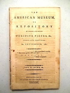
Sold20211787 Magazine First Printing of ConstitutionThe American Museum or Repository of Ancient and Modern Fugitive Pieces & c Prose and Poetical For September 1787. Published at Philadelphia by Mathew Carey MDCCLXXXVII. Vol. II Number III. COMPLETE iSee Sold Price
Sold20211787 Magazines Federalist Papers ConstitutionThe November and December 1787 issue of "The American Museum or Repositoryof Ancient and Modern Fugitive Pieces…..", Volume II Numbers V and VI, printed at Philadelphia by Mathew Carey, MDCCLXXXVII.See Sold Price
Sold2024Ohio copy of Mathew Carey’s 1796 GENERAL ATLASCarey, Mathew (publisher). CAREY’S GENERAL ATLAS. Philadelphia: Printed by Mathew Carey, May 1, 1796. FOLIO (14.75 x 9.5 inches), COMPLETE AS PUBLISHED (including a Rare Map of The United States bySee Sold Price
Sold2019United StatesTitle: United States Publication Date: c1805 Cartographer: CAREY, MATHEW ? Publisher: Size: 6.1Height - 7.1Width Anonymous pocket map, possibly from Carey's American Pocket atlas of 1805. Foxed and brSee Sold Price
Sold2016Map of Washington, DC by Carey & Lea, 1825Original map by Carey & Lea from American Atlas published in Philadelphia, 1825. Dimensions: 23” x 27” No Reserve Buyer pays shipping. This item ships from Ocean View, DE.See Sold Price
Sold2017Lavoisne: North and South America, 1821Map: Geographical, Historical, and Statistical Map of America. North America / South America Maker: Lavoisne Publisher: "Aspin, J. / E. Paguenaud. Philadelphia. M. Carey & Son. 1821 Size: North AmericSee Sold Price
Sold2018Antique Map - The Province of Maine c. 1795-96The Province of Maine, from the Best Authorities by Samuel Lewis , 1794; Copper engraving 1795-96, Engraved for Carey's American Edition of Guthries Geography improved; measures about 16 inches by 20See Sold Price
Sold2023Carey & Lea Map of South AmericaCAREY, Henry C. (1793-1879) & LEA, Isaac (1792-1886). South America. No 46. From A Complete Historical, Chronological, and Geographical American Atlas, Being a Guide to the History of North and SouthSee Sold Price
Sold2019Map of the Caracas.Reserve Reduced! Title: Map of the Caracas. Publication Date: 1814 Cartographer: CAREY, MATHEW/WARNICKE, sc. Publisher: M. CAREY Size: 12.25 x 20.3 Original outline coloring. Northeast South America.See Sold Price
Sold20231795 Carey's Am Ed of Guthries Impr Geography1795 Matthew Carey "Carey's American Edition of Guthrie's Geography Improved", 1st edition of the 1st American printed atlas, 43 of 44 maps remaining, incl Doolittle's Vermont, Virginia, the CarolinasSee Sold Price
Sold2018Delaware.Title/Content of Map: Delaware. Date: 1814 Cartographer: CAREY, MATHEW/A. DOOLITTLE Size: 7.75X5.75 From the 4th edition of Carey's American Pocket Atlas. With text. Browned. Please note that this lotSee Sold Price
Sold2018Antique Hand Colored Maps of The AmericasAntique Hand Colored Maps of The Americas. This lot features two 19th century hand colored maps of North America and South America from the Carey and Lee Atlas American Edition 1823-24. Both maps areSee Sold Price
16 mins LeftTrillium Antique Prints & Rare BooksCarey, pub. 1814 - Map of the State of Tennessee$85(2 bids)
16 mins LeftTrillium Antique Prints & Rare BooksCarey, pub. 1814 - Map of the Mississippi Territory$85(2 bids)
May 04Trillium Antique Prints & Rare BooksCarey, pub. 1814 - Map of the East Indies with India, China, & New Holland (Australia)$50(1 bid)
16 mins LeftTrillium Antique Prints & Rare BooksCarey, pub. 1814 - Map of Scotland with the Principal Roads$50
May 04Trillium Antique Prints & Rare BooksCarey & Lea's .. American Atlas - Volume with 46 Originally Hand-colored Folio Maps$1,000(1 bid)
4 days LeftAdam's AuctioneersH.C CAREY AND I.LEA (publishers) A Complete Historical, Chronological and Geographical AMERICAN€1,500
4 days LeftMichael Scarola Rare and Used BooksThe American Museum Or Repository Vol II No. VI December 1787 Federalist Papers #3-6$750
4 days LeftMichael Scarola Rare and Used BooksThe American Museum Or Repository Vol II No. V November 1787 Federalist Papers #1&2$750
Featured3 days LeftJasper521795 Lewis Map of Maryland -- The State of Maryland, from the best Authorities$360
4 days LeftAdam's AuctioneersCAREY'S General Atlas Improved and Enlarged, being a Collection of Maps of the World and Quarters,€2,200(2 bids)
May 15University Archives"The American Museum": Three Signed Volumes, Includes First Serial Printing of Constitution, Owned b$750
4 days LeftAdam's AuctioneersBARTON, William P.C.: Compendium Florae Philadelphicae containing a description of the INDIGENOUS€150


![[Map] The State of North Carolina: Lewis, Samuel. "The State of North Carolina from the best Authorities, &c." [Philadelphia: Mathew Carey, ca. 1795 or shortly after.] On heavy laid. Measured from plate-marks 49 x 29.5cm. Quite clean,](https://p1.liveauctioneers.com/3532/146911/74242522_1_x.jpg?height=310&quality=70&version=1564368564)


![[Provenance, Hamilton Fish, Fanny Kemble] (1 of 6)](https://p1.liveauctioneers.com/3532/326332/175680418_1_x.jpg?height=282&quality=70&version=1713150771)


