Sold20221831 POCKET MAP OF NEW YORK STATE BY HUMPHREY PHELPS"A Map of the State of New York, with the latest improvements.", pocket map in red leather with gilt title, 16 3/4" x 20 1/4" sheet, 4x9 fold, engraved with handcolored outlines. New York. Scale: 1"=See Sold Price
Sold2021Pocket map entitled "Map Of The State of New York WithPocket map entitled "Map Of The State of New York With The Latest Improvements / By H. Phelps", hand colored and published in 1832. The 20" x 16 1/2" size map, folds into a 5" x 2 7/8" booklet - the fSee Sold Price
Sold2024Two Maps of the United States by William Faden (London, 1785 and 1796)Two Maps of the United States by William Faden (London, 1785 and 1796) Two hand-colored maps engraved by William Faden (British, 1749-1836), London, 1785 and 1796. Titled "The United States of North ASee Sold Price
Sold2017The USA Map 1829, Engraving by W. Darton, London, UKThe United States of America, 1829 by W. Darton Junior, Holborn Hill. England. Hand colored engraved atlas map. Relief is shown pictorially. Map framed, matted and glazed. Publisher 1829, William DartSee Sold Price
Sold2016A Map of the United States & MexicoHenry Tanner (1786-1858). New York: Tanner, 1850. Hand-colored Pocket Map. 23 x 29 inches visible, 38 x 39 1/2 inches framed.See Sold Price
Sold2022J. BARTHOLOMEW HAND-COLORED ENGRAVED MAP OF USJ. Bartholomew Hand-Colored Engraving Map of United States, Mid to Late 19th C. Hand-colored engraving on wove paper. Dimensions: (Frame) 18.0" W x 15.0" H x 1.0" D Condition: Creased in the center; nSee Sold Price
Sold2024Tasso Italian Map the United States 1832TASSO, G. (19th Century). Stati-Uniti dell' America Settentrionale dalle Piu Recenti Mappe... Engraved map with original hand color. Venice, 1832. 15 1/4" x 19 3/4" sheet. Scarce map from an Italian eSee Sold Price
Sold2022(NEW ORLEANS.) Benjamin Moore Norman. Norman's Plan of New Orleans & Environs.(NEW ORLEANS.) Benjamin Moore Norman. Norman's Plan of New Orleans & Environs. Finely detailed hand-colored engraved pocket map of New Orleans with an 86-point keyed reference panel. 17¾x24½See Sold Price
Sold2022(REPUBLIC OF TEXAS.) James Hamilton Young. A New Map of Texas, with the Contiguous American &(REPUBLIC OF TEXAS.) James Hamilton Young. A New Map of Texas, with the Contiguous American & Mexican States. Hand-colored engraved map of Texas with inset text panels relating information on its riveSee Sold Price
Sold2024Pictorial Map of the United States, 1849PICTORIAL MAP OF THE UNITED STATES 1849. New York: Ensign and Thayer, [ca. 1849.] Sheet 44" x 32.25".*** An attractive hand-colored map providing a view of the United States as it was in the mid-19thSee Sold Price
Sold2020Laurie & Whittle Map of AmericaLAURIE & WHITTLE (Late 18th Century)The United States of America...Engraved map with original hand color in full.London: Laurie & Whittle, 1794.20 1/4" x 22 1/2" sheet.The first British map to show thSee Sold Price
Sold2023RARE BUCHOLTZ-LUDWIG ANTEBELLUM POCKET MAP OF VIRGINIARARE BUCHOLTZ-LUDWIG ANTEBELLUM POCKET MAP OF VIRGINIA, hand-colored lithograph, Map of the State of Virginia Containing the Counties, Principal Towns, Railroads, Rivers, Canals & All Other Internal ISee Sold Price
Sold2022(MEXICO.) Henry Schenk Tanner. A Map of the United States of Mexico,(MEXICO.) Henry Schenk Tanner. A Map of the United States of Mexico, As Organized and Defined by the Several Acts of Congress of that Republic. Large hand-colored lithographed map of southwestern NortSee Sold Price
Sold2023Sauthier & Fadden Revolutionary War Map EngravingAn original 18th Century hand colored engraved topographical map, illustrated by Claude Joseph Sauthier (1736–1802) and published by William Faden (1749-1836), the latter serving as royal geogrSee Sold Price
Sold2015Cary's New Universal Atlas,Containing Distinct Maps of All the Principal States and Kingdoms, etc., London: Printed for J. Cary, Engraver, 1811, with 56 double-page engraved hand-colored maps on 60 numbered sheets (complete), rSee Sold Price
Sold2021c 1730 Seutter Map: Novi Belgii, in America ...Historic Maps c. 1730 Historic Rare Earlier State of Seutter's Important American Northeast Map & New York City Restitutio View c. 1730 Hand-Colored Copper-Engraved Map titled, "Recens Edita totius NoSee Sold Price
Sold2018Ortelius' 1570 world mapHeading: Author: Ortelius, Abraham Title: Typus Orbis Terrarum Place Published: Antwerp Publisher: Date Published: 1570-[1584?] Description: Copper-engraved map, hand-colorSee Sold Price
Sold2022DES BARRES, JOSEPH FREDERICK WALLET The North East Shore of the Gulph of Mexico. London: circa 1780.DES BARRES, JOSEPH FREDERICK WALLET The North East Shore of the Gulph of Mexico. London: circa 1780. A very large hand-colored engraved map on four joined sheets. Overall 30 x 84 inches (76 x 214 cm).See Sold Price
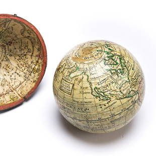
Sold2023(GLOBES.) Style of Herman Moll. A Correct Globe with the New Discoveries.(GLOBES.) Style of Herman Moll. A Correct Globe with the New Discoveries. 2¾-inch miniature terrestrial pocket globe comprised of 12 hand-colored engraved gores and 2 polar calottes on a plasterSee Sold Price
Sold2024Nicolas De Fer (French 1646-1720)Nicolas De Fer (French 1646-1720) "L Amerique Méridionale, et Septentrionale" early state hand colored map engraving dated lower right "1699" 18" x 23" Condition: overall good condition, some yellowiSee Sold Price
Sold2022Atlases to 1871 edition of American OrnithologyHeading: (Ornithology) Author: Wilson, Alexander & Charles Lucian Bonaparte Title: American Ornithology, or, The Natural History of the Birds of the United States. Plates engraved and colored from oriSee Sold Price
Sold2024Gerard Mercator (Belgian 1512 - 1594) and Rumold Mercator (Belgian 1545 - 1599)Gerard Mercator (Belgian 1512 - 1594) and Rumold Mercator (Belgian 1545 - 1599) "Orbis Terrae Compendiosa Descriptio", circa 1595 Engraved and hand colored map 14 1/2" x 19 3/4" Condition: aging, yellSee Sold Price
Sold2022Brassier A Survey of Lake ChamplainWilliam Brassier "A Survey of Lake Champlain", Sayer and Bennett, London, 1776 hand-colored map, plate size 26 1/2" x 19 1/4"See Sold Price
Sold2018J.W.Tucker & Co Gold Quartz 14K Elgin Pocket Watch w/Very Fine & Rare Elgin for California Jeweler J.W. Tucker & Co. San Francisco 14k gold 53mm hunting case pocket watch, front cover decorated with hand engraved leaf border, reverse cover decorated witSee Sold Price
7 days LeftTremont AuctionsJohn Speed and Francis Lamb "Map of New England and New York", ca. 1676. Hand colored engraved map$900(3 bids)
May 14Fleischer's Auctions1755 Map Partie de l'Amerique Septentrionale, qui comprend Le Cours de L'Ohio...$200(3 bids)
7 days LeftTremont Auctions1778 "Il Canada" original map depicting Canada and the US. Hand colored. Fold down center. Framed.$150(1 bid)
May 12Schilb Antiquarian Rare Books1844 Harper Library United States Poland Navigation MAPS 14v Voyages RARE LOT$56(5 bids)
BonhamsA George III eighteen carat gold-mounted walking cane Maker's mark WB, London, 1767£600(6 bids)
2 days LeftWillow Creek Coin & CollectiblesWilliam Hamilton (1730-1803) "Attic Kalix-Krater", Engraving, Circa 1766.$50(1 bid)


![Pictorial Map of the United States, 1849: PICTORIAL MAP OF THE UNITED STATES 1849. New York: Ensign and Thayer, [ca. 1849.] Sheet 44" x 32.25".*** An attractive hand-colored map providing a view of the United States as it was in the mid-19th](https://p1.liveauctioneers.com/3532/326332/175680404_1_x.jpg?height=310&quality=70&version=1713150771)


![Ortelius' 1570 world map: Heading: Author: Ortelius, Abraham Title: Typus Orbis Terrarum Place Published: Antwerp Publisher: Date Published: 1570-[1584?] Description: Copper-engraved map, hand-color](https://p1.liveauctioneers.com/642/127929/65081054_1_x.jpg?height=310&quality=70&version=1537227236)


![[CIVIL WAR] Black Soldier & Wife (1 of 2)](https://p1.liveauctioneers.com/7226/322253/173251671_1_x.jpg?height=282&quality=70&version=1710004847)
![[CIVIL WAR] Black Soldier CDV (1 of 2)](https://p1.liveauctioneers.com/7226/322253/173251672_1_x.jpg?height=282&quality=70&version=1710004847)


