Sold20211842 Map of SwitzerlandAuthor: Scott Title: 1842 Map of Switzerland Medium: Ink on Paper Dimensions: 11.5"X9" Map of Switzerland engraved by R. Scott dated 1842. Part of the New General Atlas of the World. Published by ThomSee Sold Price
Sold2022Butler, Samuel 1842 Lot of 5 European MapsIncl Germany/Prussia, North Italy/Switzerland, Russia, Denmark/Sweden/Norway, and Holland/Belgium. Steel Engraved Map Published 1842, London for "An Atlas of Modern Geography" by Samuel Butler. DrawnSee Sold Price
Sold2024West India Islands. Caribbean. La Salle settlement in Texas. LIZARS 1842 mapTITLE/CONTENT OF MAP: 'West India Islands and adjacent coasts of the United States, Mexico, Guatimala & Colombia' The map notes anecdotally the location of René Robert Cavelier, Sieur de La SalleSee Sold Price
Sold2023South America /Atlantic Ocean. Gran Colombia. United Provinces. LIZARS 1842 mapTitle: South America /Atlantic Ocean. Gran Colombia. United Provinces. LIZARS 1842 map Description: South America' by William Home Lizars (1842). Antique 19th century atlas map with original hand coloSee Sold Price
Sold2022MAP, Switzerland, BlaeuNorthern Switzerland. Johannes Blaeu, Territorium Basileense, cum Adjacentibus, from Le Grand Atlas..., 1663 (circa). Hand Color. This handsome and uncommon map covers the area around Basel, which isSee Sold Price
Sold20201842 map of New York City, Sidney MorseFrom the very first cerographic atlas ever published. Two tiny very lightly discolored areas at top edge; corner crease. 12 x 15. Reserve: $90.00 Shipping: Domestic: Flat-rate of $6.00 to anywhere witSee Sold Price
Sold2019MAP - Switzerland. ChatelainSwitzerland. Henry Abraham Chatelain, Carte Ancienne de la Suisse avec des Remarques Abregees sur les Divers Evenemens et Revolutions qui y sont Arrivees, et Particulierement Celles qui ont Donne LieuSee Sold Price
Sold20201842 Map of North AmericaAuthor: Scott Title: 1842 Map of North America Medium: Ink on Paper Dimensions: 9"X11.5" Map of North America dated 1842. Engraved by R. Scott. Part of the New General Atlas of the World. Published bySee Sold Price
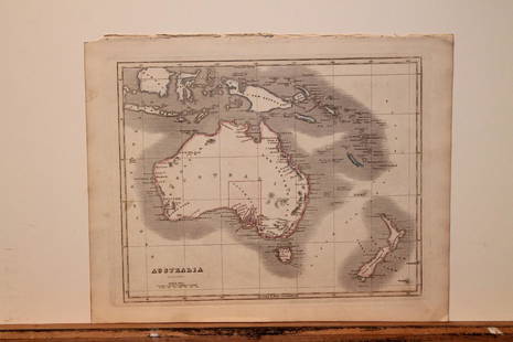
20201842 Map of AustraliaAuthor: Scott Title: 1842 Map of Australia Medium: Ink on Paper Dimensions: 11.5X9" Description: Map of Australia dated 1842. Copper plate map. Engraved by R. Scott. Published by Thomas Nelson in EdinSee Sold Price
Sold20201842 Map of AsiaAuthor: Scott Title: 1842 Map of Asia Medium: Ink on Paper Dimensions: 11.5"X 9" Description: Map of Asia dated 1842. Copper plate map. Engraved by R. Scott. Published by Thomas Nelson in Edinburgh. PSee Sold Price
Sold20201842 Map of AustraliaAuthor: Scott Title: 1842 Map of Australia Medium: Ink on Paper Dimensions: 11.5"X9" Map of Australia dated 1842. Copper plate map. Engraved by R. Scott. Published by Thomas Nelson in Edinburgh. PartSee Sold Price
Sold20201842 Map of AfricaAuthor: Scott Title: 1842 Map of Africa Medium: Ink on Paper Dimensions: 11.5 X 9" Description: Map of Africa dated 1842. Copper plate map. Engraved by R. Scott. Published by Thomas Nelson in EdinburgSee Sold Price
Sold20201842 Map of North AmericaTitle: 1842 Map of North America Author: Nelson Medium: Ink on Paper Dimensions: 9"X11.5" Description: Map of North America dated 1842. Engraved by R. Scott. Part of the New General Atlas of the WorldSee Sold Price
Sold20201842 Map of ChinaAuthor: Scott Title: 1842 Map of China Medium: Ink on Paper Dimensions: 9"X11.5" Description: Map of China dated 1842. Copper plate map. Engraved by R. Scott. Published by Thomas Nelson in Edinburgh.See Sold Price
Sold20211842 Map of FranceAuthor: Scott Title: 1842 Map of France Medium: Ink on Paper Dimensions: 11.5"X9" Map of France engraved by R. Scott dated 1842. Part of the New General Atlas of the World. Published by Thomas NelsonSee Sold Price
Sold20211842 Map of GreeceAuthor: Scott Title: 1842 Map of Greece Medium: Ink on Paper Dimensions: 11.5"X9" Map of Greece dated 1842. Engraved by R. Scott. Part of the New General Atlas of the World. Copper plate engraving. PuSee Sold Price
Sold20211842 Map of the East IndiesAuthor: Scott Title: 1842 Map of the East Indies Medium: Ink on Paper Dimensions: 11.5"X9" Map of the East Indies dated 1842. Engraved by R. Scott. Part of the New General Atlas of the World. Copper pSee Sold Price
Sold2022Canada 1842 Map by W. Hughes/BartlettSteel Engravinged Map Published 1842 by George Virtue, London for "Canadian Scenery Illustrated..." by Nathaniel P. Willis. Illustrated by William H. Bartlett. Map drawn and engraved by William HughesSee Sold Price
Sold20211842 Map of RussiaAuthor: Scott Title: 1842 Map of Russia Medium: Ink on Paper Dimensions: 9"X11.5" Map of Russia in Europe dated 1842. Engraved by R. Scott. Part of the New General Atlas of the World. Copper plate engSee Sold Price
Sold2022Barclay, James C1800 Hand Col Map. SwitzerlandHand Colored Copper Engraved Map Published C1800 Halifax & Newcastle, England for "Barclay's Universal English Dictionary…" by James Barclay. Maps Engraved by Clerk, Milton and others. Paper Size: 1See Sold Price
Sold2021Tallis, John (Pub) 1852 Map. SwitzerlandSteel Engraved Map with Original Outline Hand Color Published 1852-56 by John Tallis, London for "The Universal Pronouncing Dictionary" by Thomas Wright. Drawn & Engraved by John Rapkin. Centre fold aSee Sold Price
Sold2021Thomson, John (Pub) 1825 Map. SwitzerlandCopper Engraved Map Published 1825 by John Thomson, Edinburgh for "The Edinburgh School Atlas" by N. R. Hewitt. Maps Engraved by Hewitt. Engraved Vignette in corner. Original Outline Hand Colour. RareSee Sold Price
Sold2019Starling & Goldsmith 1842 Map of World HemispheresSteel Engraved Map Published 1842, London for "Goldsmith's Grammar of Geography" by W. S. Kenny and the Rev. Goldsmith. Folds as issued. Paper Size: 7 x 4 inch (18 x 11cm) ApproxSee Sold Price
Sold2022Lizars, Daniel 1831 LG Rare HC Map. SwitzerlandLarge Folio Copper Engraved Map Published 1831-2 by John Hamilton, Successor to Daniel Lizars, Edinburgh for "The Edinburgh Geographical and Historical Atlas..." First Edition by Daniel Lizars. Very fSee Sold Price
May 12Schilb Antiquarian Rare Books1869 ATLAS 42 MAPS America Africa Australia GERMANY Switzerland Sydow RARE$155(4 bids)
May 11Trillium Antique Prints & Rare BooksWilkes - Pair of Maps of California and the Pacific Ocean$100
May 11Trillium Antique Prints & Rare BooksBraun & Hogenberg, pub. 1575 - View of Basel, Switzerland$100
May 11Trillium Antique Prints & Rare BooksWilkes - 3 Maps of Australian, Samoan or Navigator Islands, & Island of Tahiti$100
May 11Trillium Antique Prints & Rare BooksWilkes - Corrobory (Corroboree) Dance (Australian Aboriginal Custom)$100
6 hrs LeftTrillium Antique Prints & Rare BooksKarl Bodmer - Dog-Sledges of the Mandan Indians. 29$300
6 hrs LeftTrillium Antique Prints & Rare BooksMcKenney & Hall - 3 Folio Native American Lithographs$200
6 hrs LeftTrillium Antique Prints & Rare BooksKarl Bodmer - Tower-Rock, view on the Mississippi. 9$300