Sold20231859 Southern Africa. Map By ColtonTitle: 1859 Southern Africa. Map By Colton Date/Period: 1859 Materials: Hand colored steering engraved Size: 17 1/2 x 14 1/2” This hand-colored, steel-engraved map showcases the region from theSee Sold Price
Sold20221855 Colton Map of Southern Africa -- Africa Southern SheetTitle: 1855 Colton Map of Southern Africa -- Africa Southern Sheet Cartographer: J Colton Year / Place: 1855, New York Map Dimension (in.): 11.8 X 15.3 in. This is a very nice map of southern Africa iSee Sold Price
Sold2018Colton: Antique Map of Southern Italy, 1859Southern Italy with Sicily & Sardinia and insert of Malta 1859 H.J. Colton 17 1/2" x 15" Hand colored and engraved. Published in New York in Colton's 'General Atlas'. Please note that this lot has a cSee Sold Price
Sold2018Colton: Antique Map of North Eastern Africa, 1859Title/Content of Map: North eastern Africa by Colton Date Printed: 1859 Cartographer: H.J. Colton Material/Medium: Paper Size: 17 1/2" X 15" Hand colored,engraved. Published in New York in 'Colton's GSee Sold Price
Sold2017J. H. Colton: Africa (Southern Sheet) MapAfrica (southern sheet), 17 x 14 in, 1857, J. H. Colton Please note that this lot has a confidential reserve. When you leave a bid in advance of the auction, submit your maximum. Jasper52 will bid onSee Sold Price
Sold2022Reed's Guide to the Kansas Gold Region; Reprint [151390]1959 reprint of Reed's Guide to the Kansas Gold Region, With a Map Embracing the Northern and Southern Routes, from the Missouri River to Pike's Peak. Originally published by J.H. Colton in 1859. TherSee Sold Price
Sold20201859 Colton Map of Paris -- The Environs of ParisTitle: 1859 Colton Map of Paris -- The Environs of Paris Cartographer: J Colton Year/Place: 1859, New York Size: 12.1 X 14.7 in. Additional Information: This is a very attractive city map of greater PSee Sold Price
Sold2022Rare J.H. Colton Map, Southern Regions, Antarctica, South PoleRare mid 19th Century map of Southern Regions, Antarctica, South Pole, The Southern Polar Regions by J. H. Colton, from an 1855 first edition, Colton's Atlas of The World. A rare look at Antarctic expSee Sold Price
Sold2023Findlay, Alexander 1828 Map. Southern AfricaCopper Engraved Map Published 1828, London for "The Oxford Encyclopaedia: Or, Dictionary of Arts, Sciences and General Literature" by Rev. W. Harris, J. A. Stewart, C. Butler, Rev. J. H. Hinton et al.See Sold Price
Sold2019Southern Africa with MadagascarTitle/Content of Map: Southern Africa with Madagascar Date: 1598/99 Cartographer: By Ruscelli Size: 11x9” Provenance: Venice Reserve: $150.00 Shipping: Domestic: Free shipping to anywhere within theSee Sold Price
Sold2020Bartholomew, John 1922 Lot of 4 Maps of South AfricaIncl Cape Province/Transvaal - East, Cape Province/Transvaal - West, South Africa and Central/Southern Africa. Large Lithograph Maps Published 1922 by The Times, London for "The Times Survey Atlas ofSee Sold Price
20231859 Map of Texas. By ColtonTitle: 1859 Map of Texas. By Colton Date/Period: 1859 Materials: Hand colored steering engraved Size: 17 1/2 x 14 1/2” br>Texas right before the civil war, inserts the northern part of the stateSee Sold Price
Sold20231859 Map of Texas. By ColtonDescriptionTitle: 1859 Map of Texas. By ColtonDate/Period: 1859Materials: Hand colored steering engravedSize: 17 1/2 x 14 1/2”br>Texas right before the civil war, inserts the northern part of thSee Sold Price
20231859 Map of Florida by ColtonTitle: 1859 Map of Florida by Colton Date/Period: 1859 Materials: Steel engraved Size: 17 1/2 x 14 1/2” Florida with Florida keys in the insert. From before the civil war. By J. H. Colton & G. WSee Sold Price
Sold20231859 Map of Florida by ColtonTitle: 1859 Map of Florida by Colton1859 Materials: Steel engraved Size: 17 1/2 x 14 1/2” Florida with Florida keys in the insert. From before the civil war. By J. H. Colton & G. W. Colton. From "GeSee Sold Price
Sold202318th Century Map Of Southern Africa & The Congo18th Century Map Of Southern Africa & The Congo. Titled "Carte du Royaume de Congo, du Monomotapa et de la Cafrerie. Dressee sur les Memoires les plus exacts & les observations les plus Nouvelles.// MSee Sold Price
Sold20191855 Colton Map of Southern Italy -- Southern Italy,Title/Content of Map: 1855 Colton Map of Southern Italy -- Southern Italy, Kingdom of Naples, I. Sardinia & Malta Date: 1855, New York Cartographer: J Colton Size: 11.8 X 14.6 in. This is a very niceSee Sold Price
Sold20231859 Map of Connecticut by ColtonTitle: 1859 Map of Connecticut by Colton Date/Period: 1859 Materials: Steel engraved Size: 17 1/2 x 14 1/2” Connecticut. Shows, rivers, lakes, counties cities, towns, villages, roads, and rail lSee Sold Price
Sold20231855 Colton Handcolored Map, Southern Italy Kingdom of NaplesSouthern Italy Kingdom of Naples Sardinia & Malta, dated 1855, beautifully engraved, pastel colored map of Southern Italy &identifies various cities, towns, rivers, rapids, mountain passes, and an assSee Sold Price
Sold2021Framed Map Of Southern Africa Dated 1895Framed Map Of Southern Africa Dated 1895 . 20" X 17 1/4"See Sold Price
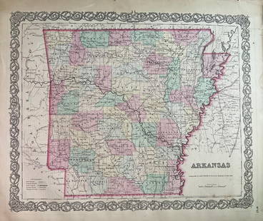
Sold20231859 Map of Arkansas by ColtonTitle: 1859 Map of Arkansas by Colton Date/Period: 1859 Materials: Steel engravedSize: 17 1/2 x 14 1/2” Arkansas. From before the civil war. By J. H. Colton & G. W. Colton. From "General Atlas".See Sold Price
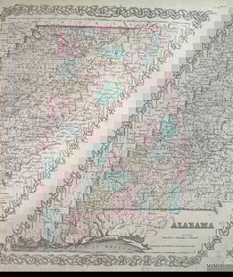
Sold20231859 Map of Alabama by ColtonTitle: 1859 Map of Alabama by Colton Date/Period: 1859 Materials: Steel engravedSize: 17 1/2 x 14 1/2” Alabama. From before the civil war. By J. H. Colton & G. W. Colton. From "General Atlas". PSee Sold Price
Sold2022Africa.- Fries (Lorenz) [Tabula Nova Partis Africae], woodcut map, [c. 1525].Africa.- Fries (Lorenz) [Tabula Nova Partis Africae], rare Ptolemaic map of Southern Africa, a reduced version of Waldseemuller's map of 1513, from 'Claudii Ptolemaei Geographicae...', woodcut with fuSee Sold Price
Sold2016Metellus (Johannes) - Regnum Monomotapae,early map of Southern Africa and Madagascar, strapwork title cartouche below, from Botero's Theatrum Principum Orbis Universi, engraved map, 15 x 230mm., Latin text verso, full margins, central verticSee Sold Price
May 12Schilb Antiquarian Rare Books1859 AFRICA VOYAGES Barth Timbuktu Tripoli SLAVES Illustrated Slavery MAP African$62(4 bids)
7 days LeftJasper52Windward or South Caribbean Islands. Barbados St. Lucia. Guianas. LOWRY 1859 map$60
7 days LeftJasper52Leeward Islands. Cuba, Hayti/Haiti or Santo Domingo, Puerto Rico. LOWRY 1859 map$100


![Reed's Guide to the Kansas Gold Region; Reprint [151390]: 1959 reprint of Reed's Guide to the Kansas Gold Region, With a Map Embracing the Northern and Southern Routes, from the Missouri River to Pike's Peak. Originally published by J.H. Colton in 1859. Ther](https://p1.liveauctioneers.com/2699/258185/134287651_1_x.jpg?height=310&quality=70&version=1660347389)


![Africa.- Fries (Lorenz) [Tabula Nova Partis Africae], woodcut map, [c. 1525].: Africa.- Fries (Lorenz) [Tabula Nova Partis Africae], rare Ptolemaic map of Southern Africa, a reduced version of Waldseemuller's map of 1513, from 'Claudii Ptolemaei Geographicae...', woodcut with fu](https://p1.liveauctioneers.com/5458/260724/135800393_1_x.jpg?height=310&quality=70&version=1662479034)


