Sold20211867 Colton Map of Minnesota -- MinnesotaTitle: 1867 Colton Map of Minnesota -- Minnesota Cartographer: G & C Colton Year / Place: 1867, New York Map Dimension (in.): 23.3 X 16.8 in. This is an excellent doubble page map of Minnesota. The noSee Sold Price
Sold2017Colton: Antique Map of Minnesota, 1867Huge 1867 Minnesota map by Colton. Very fine example of this early large format map. Finely engraved map of the state with inset of the north-eastern portion at upper right. Highly detailed with identSee Sold Price
Sold20201855 Colton Map of Minnesota and the Dakotas --Title: 1855 Colton Map of Minnesota and the Dakotas -- Minnesota Cartographer: J Colton Year/Place: 1855, New York Size: 11.8 X 15.7 in. Description: This is an excellent map of Minnesota and the emerSee Sold Price
Sold20191855 Colton Map of Minnesota and the Dakotas --Reserve Reduced! Title/Content of Map: 1855 Colton Map of Minnesota and the Dakotas -- Minnesota Date: 1855, New York Cartographer: J Colton Size: 11.8 X 15.7 in. This is an excellent map of MinnesotaSee Sold Price
Sold2017Colton: Antique Map of Minnesota, 1855Extremely clean 1855 Colton map of Minnesota. From the 1856 edition of Colton’s Atlas of the World. A virtually spotless map. Lovely full hand-color and impression. Two tiny, light margin spotsSee Sold Price
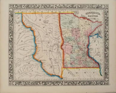
Sold2018Colton: Antique Map of Minnesota & Dakota, 1859Title/Content of Map: Minnesota & Dakota by Colton Date Printed: 1859 Cartographer: H.J. Colton Material/Medium: Paper Size: 17 1/4" X 15" Hand colored,engraved. Published in New York in 'Colton's GenSee Sold Price
Sold2017Colton: Antique Map of Minnesota, 1871Title/Content of Map: Minnesota by Colton Date Printed: 1871 Cartographer: G. W. Colton Material/Medium: Paper Size: 15" x 17" Hand colored lithograph. From 'Colton's American Atlas.' Published in NewSee Sold Price
Sold2018Early pocket map of MinnesotaHeading: Author: Colton, J.H. Title: Minnesota Place Published: New York Publisher:J.H. Colton & Co Date Published: 1855 Description: Folding color map, 12 x 15 inches. FolSee Sold Price
Sold2022Scarce 1855 Minnesota from Colton’s Atlas of the WorldImportant early atlas map of Minnesota Territory, immediately after the creation of Dakota Territory. This map appeared in the 1856 Colton 2-volume Atlas of the World. Map is by Johnson & Browning. ItSee Sold Price
Sold2020MinnesotaTitle/Content of Map: Minnesota Cartographer: COLTON, JOSEPH HUTCHINS Date: 1857 Publisher: J.H. COLTON & CO. Size: 11.75Height - 15.5Width Shows railroads including the proposed Northern Route of theSee Sold Price
2018MinnesotaReserve Reduced! Item: Minnesota Date: 1867 ca. Cartographer: COLTON, GEORGE WOOLWORTH Publisher: G.W. & C.B. COLTON Size (inches): 23.5X16.5 Shows railroads, completed and projected. SCARCE DATE & SISee Sold Price
Sold20231859. Minnesota & Dakota territory. By Colton>Title: 1859. Minnesota & Dakota territory. By Colton Date/Period: 1859 Materials: Steel engraved Size: 17 1/2 x 14 1/2” Minnesota and Dakota territory. Important map in the settlement of the regionSee Sold Price
Sold2020MinnesotaTitle: Minnesota Publication Date: 1856 Cartographer: Publisher: J.H. Colton & Co. Brief Descriptions: 1st edition. Map showing MN west to White Earth River. Details many towns, topo., Indian tribes &See Sold Price
Sold20191938 R Taylor White Pictorial Map of Minnesota --Title: 1938 R Taylor White Pictorial Map of Minnesota -- Minnesota Date: 1938, Boston Cartographer: Ruth Taylor White Size: 11.6 x 8.5 in. Additional Information: This is Ruth Taylor White's charmingSee Sold Price
Sold20221876 Mitchell Map of Minnesota -- County Map of MinnesotaTitle: 1876 Mitchell Map of Minnesota -- County Map of Minnesota Cartographer: S Mitchell Year / Place: 1876 Philadelphia Map Dimension (in.): 13.8 X 11.4 in. This is a very nice map of Minnesota, witSee Sold Price
Sold20201860 Mitchell Map of Minnesota and the DakotasTitle/Content of Map: 1860 Mitchell Map of Minnesota and the Dakotas --Minnesota and Dacotah Date: 1860, Philadelphia Cartographer: S Mitchell Size: 10.6 X 13.3 in. This is a rather nice map of MinnesSee Sold Price
Sold20231864 Johnson Map of Dakota Territory and Minnesota -- Johnson's Minnesota and DakotaTitle: 1864 Johnson Map of Dakota Territory and Minnesota -- Johnson's Minnesota and Dakota Cartographer: Johnson & Ward Year / Place: 1864, New York Map Dimension (in.): 12.5 x 15.9 in. This is a verSee Sold Price
Sold20241863 Johnson Map of Dakota Territory and Minnesota -- Johnson's Minnesota and DakotaDescriptionTitle: 1863 Johnson Map of Dakota Territory and Minnesota -- Johnson's Minnesota and DakotaCartographer: Johnson & WardYear / Place: 1863, New YorkMap Dimension (in.): 12.5 x 15.9 in.This iSee Sold Price
Sold20181864 Johnson Map of Dakota Territory and MinnesotaTitle/Content of Map: 1864 Johnson Map of Dakota Territory and Minnesota -- Johnson's Minnesota and Dakota Date Printed: 1864, New York Cartographer: Johnson & Ward Size: 12.5 x 15.6 in. This is an inSee Sold Price
Sold20201861 Johnson Map of Dakota Territory and Minnesota --Title/Content of Map: 1861 Johnson Map of Dakota Territory and Minnesota -- Johnson's Minnesota and Dakota Cartographer: Johnson & Ward Year/Place: 1861, New York Size: 12.5 x 15.9 in. This is an inteSee Sold Price
Sold2017Colton MAP OF THE STATE OF MISSISSIPPI 1867 EngravedDetails: COLTON, George W. (1827-1901) & Charles B. (1832-1916). Colton's Map of the State of Mississippi. New York: G.W. & C.B. Colton & Co., 1867. Engraved folding pocket map, full contemporary hanSee Sold Price
Sold2019Minnesota, Dakota’sTitle/Content of Map: Minnesota, Dakota’s Date: 1863 Cartographer: By Johnson & Ward. From, Johnson’s New Illustrated Family Atlas Size: 18x14” Provenance: New York Additional Info: Hand coloredSee Sold Price
Sold2017Mitchell: Antique Map of Minnesota, 1869Title/Content of Map: Minnesota by Mitchell Date Printed: 1869 Cartographer: Augustus S. Mitchell Material/Medium: Paper Size: 12" x 15" Hand colored engraved Map. From 'Mitchell's New General Atlas.'See Sold Price
Sold20221930's Road Maps Minnesota, Oregon & Ontariorated 7 to 8, 9"x4", light wear.See Sold Price
1 day LeftRapid Estate Liquidators and Auction GalleryReprint From The Original Coltons Map 1855 No.30 Copyright 1967$20