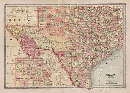
Sold20231890'S TEXAS MAP PRINTED IN 19021890'S TEXAS MAP PRINTED IN 1902. Height: 22.75 in. by Width: 29.75 in. by Depth: 1See Sold Price
Sold2021East Texas 1890Title/Content of Map: East Texas 1890 Date Printed: 1890 Material/Medium: Paper Size: approx.14 x22 inches Peerless Atlas of the World Published by Mast, Crowell & Kirkpatrick Reserve: $35.00 ShippingSee Sold Price
Sold20231902 Rand-McNally Railroad Map of IowaThis is a state of Iowa railroad map from 1902, printed by Rand-McNally. Beautiful full color wall map measuring 47” x 32”. Paper on linen, with both dowels firmly attached on the top andSee Sold Price
Sold2023Texas 1889Title/Content of Map: Texas 1889 Date Printed: 1889 Material/Medium: paper Size: approx 13.5"x21" Mast, Crowell & Kirkpatrick Reserve: $45.00 Shipping: Domestic: Flat-rate of $15.00 to anywhere withiSee Sold Price
Sold2020Texas 1886Title/Content of Map: Texas 1886 Date Printed: 1886 Material/Medium: Paper Size: approx 21.5x13.5 inches The People's Family Atlas of the World, Chicago Reserve: $20.00 Shipping: Domestic: Flat-rateSee Sold Price
Sold20201890 Map of TexasAuthor: Gaskell Title: 1890 Map of Texas Medium: Ink on Paper Dimensions: 21.5"X13.5" Map of Texas dated 1890. This double folio map was part of Gaskell's Atlas of the World. Published by John F. WaitSee Sold Price
Sold2018Johnson Map of TexasNew Map of the State of Texas. Steel engraving with original hand color. New York, Johnson & Ward, 1864. 17 1/2 inches x 25 1/2 inches sheet, 26 1/2 x 37 inches framed Beautiful map of Texas printed dSee Sold Price
Sold2023HOLY ROMAN EMPIRE. Europe in 1360 1902 old antique vintage map plan chartTITLE/CONTENT OF MAP: 'Europe in 1360' DATE PRINTED: 1902 IMAGE SIZE: Approx 25.0 x 33.5cm, 10 x 13.25 inches (Large) TYPE: Antique colour map. This map was published in 1902 but it may depict an earlSee Sold Price
Sold2024WESTERN ASIA IN 1600 AD. under the Turks & Persians 1902 old antique map chartTITLE/CONTENT OF MAP: 'Western Asia under the Turks & Persians A.D. 1600; Inset map of Southern Arabia' DATE PRINTED: 1902 IMAGE SIZE: Approx 25.0 x 33.0cm, 9.75 x 13 inches (Large) TYPE: Antique coloSee Sold Price
Sold2018County Map of Texas.Title/Content of Map: County Map of Texas. Date Printed: 1870 Cartographer: MITCHELL, SAMUEL AUGUSTUS (JR.) Material/Medium: S. Augustus Mitchell, Jr. Size: 9.25X12 Inset of Galveston Bay and VicinitySee Sold Price
Sold2017Mitchell: Antique Map of Texas, 1852Map: 1852 Mitchell Map of Texas -- Map of the State of Texas Date Printed: 1852, Philadelphia Cartographer: S Mitchell Size: 8 x 10.5 in. Condition: Very good. Toning and finger soiling, mostly in theSee Sold Price
Sold2020Texas, Indian Terratory 1888Title/Content of Map: Texas, Indian Terratory 1888 Date Printed: 1888 Material/Medium: paper Size: approx 11x14 inches Additional Info: John C. Lonngren & Son Standard Atlas of the World Reserve: $20See Sold Price
Sold20211902 Map of FloridaAuthor: Century Title: 1902 Map of Florida Medium: Ink on Paper Dimensions: 11.5"X16.5" Map of Florida dated 1902. Printed for and published by The Century Co. in New York. Double folio. This is the bSee Sold Price
Sold20211902 Map of LouisianaTitle: 1902 Map of Louisiana Author: Century Medium: Ink on Paper Dimensions: 16"X11.5" Description: Map of Louisiana dated 1902. Printed for and published by The Century Co. in New York. Double folioSee Sold Price
Sold20211902 Map of GeorgiaAuthor: Century Title: 1902 Map of Georgia Medium: Ink on Paper Dimensions: 11.5"X16.5" Map of Georgia dated 1902. Printed for and published by The Century Co. in New York. Double folio. This is the bSee Sold Price
Sold20211890 Map of West TexasTitle: 1890 Map of West Texas Medium: Ink on Paper Dimensions: 14.5"X22.5" Description: Map of West Texas dated 1890. Engraved and published by George Cram in Chicago. Part of his Family Atlas. DoubleSee Sold Price
Sold2021West Texas 1901Title/Content of Map: West Texas 1901 Date Printed: 1901Material/Medium: Paper Size: approx 14x21.5 inches Fort Dearborn Publ. Co., The National Standard Atlas Reserve: $30.00 Shipping: Domestic: FlSee Sold Price
Sold20231902 National Publishing Company Wall Map1902 roll down wall map printed by the National Publishing Company New Railroad, Post office, Township, and County Map of New York which measures approximately 48" by 41". Condition - fine.See Sold Price
Sold20211902 Tennessee MapTitle: 1902 Tennessee Map Author: Century Medium: Ink on Paper Dimensions: 11.5"X16" Description: Map of Tennessee dated 1902. Printed and published by The Century Co. in New York. Dual map divided inSee Sold Price
Sold2023Eight Antique Maps of TexasEight Antique Maps of Texas , incl. "Map of the United States and Texas Boundary Line...", 1857-1860 (1902); "Map of a Tour from Independence...by A. Wislizenus, in 1846 and 1847"; "N.W. Corner & Pan-See Sold Price
Sold20181871 Mitchell Map of Texas -- XIII TexasTitle/Content of Map: 1871 Mitchell Map of Texas -- XIII Texas Date Printed: 1871, Philadelphia Cartographer: S Mitchell / Butler Co. Size: 8.3 x 10.5 in. This is very nice map of Texas, part of a schSee Sold Price
Sold20221885 Two-page Railroad map of TexasCram’s 1885 double-page railroad map of Texas has exceptional printed color. Every railroad line in the state is highlighted in a heavier black line than such things as county borders, rivers anSee Sold Price
Sold20211902 Map of North CarolinaAuthor: Century Title: 1902 Map of North Carolina Materials: Ink on Paper Size/Dimensions: 16"X11.5" Description: Map of North Carolina dated 1902. Printed for and published by The Century Co. in NewSee Sold Price
Sold2021Texas, Oklahoma, Indian Terr. 1900Title/Content of Map: Texas, Oklahoma, Indian Terr. 1900 Date Printed: 1900 Material/Medium: paper Size: approx. 21x13 inches. . Additional Info: Mast, Crowell & Kirkpatrick - 2 folds, edges repairedSee Sold Price
May 30Antiques Online AuctionsVintage Texas 1845 Map Printed in 1986, Compiled by John Davis$1(1 bid)
5 days LeftJasper52WESTERN ASIA IN 786 AD. under the Abbāsid Abbasid Caliphs 1902 old antique map$20
3 days LeftKensington Estate AuctionAlbum Of 19th C. Albumen Photographs Of The Pacific Northwest (100+)$110(2 bids)
Jun 07Freeman's | HindmanCUNARD, Nancy, editor. Negro Anthology. 1934. FIRST EDITION. ASSOCIATION COPY WITH NOEL SULLIVAN$2,000
Featured5 days LeftJasper52Carte L’Asie. Asia. Mughal Empire. Oirat Kingdom. Tartary. VAUGONDY 1750 map$280
5 days LeftJasper52Les Indes Orientales… South Asia India Indochina Tibet. VAUGONDY 1751 map$120
7 days LeftKinghams AuctioneersTolkien, J.R.R. 'The Hobbit, or There and Back Again', 1st ed, 1st impression, pub Allen & Unwin,£3,400
Jun 06Freeman's | HindmanSTEVENSON, Robert Louis (1850-1894). Treasure Island. London, Paris & New York: Cassell & Company,$1,500