Sold20211930 Shurtleff Pictorial Map of Massachusetts -- Map ofTitle: 1930 Shurtleff Pictorial Map of Massachusetts -- Map of Massachusetts The Old Bay State Cartographer: E. Shurtleff Year / Place: 1930, New York Map Dimension (in.): 24 x 37 in. This is a very iSee Sold Price
Sold2021Boston Massachusetts Pictorial MapThe Colour of an Old City. Edwin Olsen and Blake Clark. Houghton Mifflin, Boston: 1926. Illustrated map. Ex library. 28 1/2" x 38".See Sold Price
Sold20211938 R Taylor White Pictorial Map of Massachusetts --Title: 1938 R Taylor White Pictorial Map of Massachusetts -- Massachusetts Cartographer: Ruth Taylor White Year / Place: 1938, Boston Map Dimension (in.): 11.6 x 8.5 in. This is Ruth Taylor White's chSee Sold Price
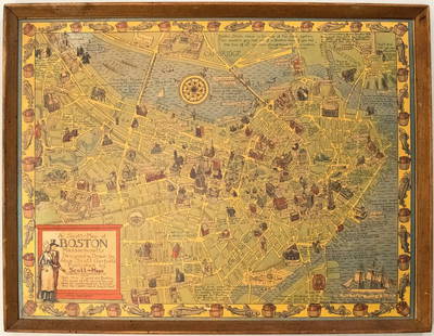
Sold20191950s Garfield Pictorial Map of Boston -- A Scott-MapTitle: 1950s Garfield Pictorial Map of Boston -- A Scott-Map of Boston Massachusetts Date: ca. 1950, Concord, MA Cartographer: A Scott Garfield Size: 20.7 x 27 in. Additional Information: A very attraSee Sold Price
Sold2020RUTH TAYLOR WHITE CARTOGRAPHS MAPSMATTED ORIGINAL 1930'S WHIMSICAL PICTORIAL CARTOGRAPHS MAPS BY RUTH TAYLOR WHITE (3 PCS)See Sold Price
Sold2023Vintage PosterA E Taylor (1887-1959) Pratt's High Test Plan of the Bath Road, original lithograph pictorial map poster 1930 - 49 x 74 cmSee Sold Price
Sold2017White: Vintage Pictorial Map of Oahu, 1930Map: 1930 White Map of Oahu -- The Island of Oahu Cartographer: R White Year / Place: 1930 Map Dimensions: 11.3 x 14.6 in. Condition: Very Good. Nice colored impression. Very little toning. A very attSee Sold Price
Sold20201930 Japanese Mainichi Newspaper World Air RouteTitle: 1930 Japanese Mainichi Newspaper World Air Route Pictorial Map -- Conquer Sky Sugoroku [World Air Route Map] Cartographer: Mainichi Newspaper Year / Place: 1930, Osaka Map Dimension (in.): 26.8See Sold Price
Sold2021Scheuerle pictorial map of Glacier National Park, 1930Heading: (Montana) Author: Scheuerle, Joe Title: Great Northern Recreational Map of Glacier National Park Montana: Waterton Lakes National Park, Alberta Place Published: [St. Paul, Minnesota] PublisheSee Sold Price
Sold2021Charles W. Smith, Pictorial Map of Virginia"A Historical Map of Virginia" by artist Charles William Smith, (1893-1987, American,) copyrighted 1930 by Charles W. Smith, Offset lithography by Garrett & Massie, Inc., Richmond, Virginia. CopiouslySee Sold Price
Sold20191930 Map of the Brookfield Chicago Zoo --Official MapTitle/Content of Map: 1930 Map of the Brookfield Chicago Zoo --Official Map (of) Chicago Zoological Park Brookfield… Date: 1930 ca. Cartographer: Size: 13.3 x18 in. A wonderful folding pictorial mapSee Sold Price
Sold2022Old Houses in England, Chunter, 1930CHUNTER, ROWLAND. Old Houses in England. New York: John Wiley & Sons; London: Chapman & Hall, 1930. Folio (13 3/4" x 10 3/4"). Red gilt cloth, pictorial map endpapers. Full-page black and white photogSee Sold Price
Sold2023SCHEUERLE, Joseph (1873—1948). Great Northern / Recreationa...SCHEUERLE, Joseph (1873—1948). Great Northern / Recreational Map of Glacier National Park Montana. 1930. Louis F. Dow Co., St. Paul, MN. 17 ¾ x 31½”. A pictorial map from the GreSee Sold Price
Sold2020Grenfell Mat / RugTitle: Grenfell Mat / Rug Date/Period: 1930's Materials: Cotton and Silk Dimensions: 12.75" x 15" From a Private Collection. Classic Example of a pictorial map of Newfoundland and Labrador showing locSee Sold Price
Sold2018Official map Chicago Zoological Park Brookfield nearTitle/Content of Map: Official map Chicago Zoological Park Brookfield near Riverside Date: 1930 ca. Cartographer: Size: 13.25X18 Color pictorial plan of the zoo grounds. Plan of the Chicago Zoo GroundSee Sold Price
Sold20171858 Berkshire Massachusetts Map1858 Berkshire Massachusetts map. Marked and dated "Henry R. Walling/1858". Frame overall 64" x 65".See Sold Price
Sold2023[PICTORIAL MAPS]. Five maps. Includes: GREEN, Mildred C. A ...[PICTORIAL MAPS]. Five maps. Includes: GREEN, Mildred C. A Romance Map of New Jersey. 1935. Buffalo: Whitney-Graham Company. Inc. Colorful pictorial map with small illustrations and explanations of NeSee Sold Price
Sold2018Melrose, Massachusetts Map and PaintingTwo Melrose, Massachusetts related items, including: map of Melrose dated 1875, 10 1/2" x 13 1/2", frame 18" x 21"; watercolor painting of Els Pond in Melrose by W. Hamilton Hope, signed L/L, dated OcSee Sold Price
Sold2023[PICTORIAL MAPS]. Two maps. Includes: JANNOT, J.B. (“Jan Lo...[PICTORIAL MAPS]. Two maps. Includes: JANNOT, J.B. (“Jan Loup”). Grand Circuit Des Capitales. France: Agence Francaise de Propagande. Promotional map of Europe and Asia for Menier chocolatSee Sold Price
Sold2022Worcester & Massachusetts Maps Early 19th Century, FoldoutMap of Massachusetts 1839 Book - A bit torn, others have some wear. Please see photos and come to the 2 day preview for condition.See Sold Price
Sold20231810 Modern Geography America MAP + World Map Massachusetts Elijah Parish1810 Modern Geography America MAP + World Map Massachusetts Elijah Parish Elijah Parishs “New System of Modern Geography” is an early 19th-century American geography textbook. Published inSee Sold Price
Sold20181945 Forest Lawn, CA Pictorial Map -- Pictorial Map ofTitle/Content of Map: 1945 Forest Lawn, CA Pictorial Map -- Pictorial Map of Forest Lawn Memorial - Park, Glendale, California Date: 1945, Glendale CA Cartographer: Forest Lawn Assoc. Size: 23.5 X 18.See Sold Price
Sold2022Lunenburg, Massachusetts Map in Needlepoint29.5h x 21w inches. Note: This lot can not be shipped in house. Buyer must arrange shipping for this item or pick up this lot.See Sold Price
Sold20232 Vintage Massachusetts Maps Lunenburg & Fitchburg2 vintage, possibly antique maps of county’s within Massachusetts. 1 map reads Lunenburg, written on lower half in graphite, 1870 the other reads Fitchburg. Both maps appear pulled from a book withSee Sold Price
6 hrs LeftPotter & Potter AuctionsPictorial Map of Hollywood and Vicinity / Hollywood Film Ca...$150(2 bids)
6 hrs LeftPotter & Potter Auctions[NEW YORK CITY – PICTORIAL MAPS]. Group of 3 pictorial maps...$200(1 bid)
6 hrs LeftPotter & Potter Auctions[PICTORIAL MAPS – TRAVEL]. Three Pictorial Maps. 1940s/50s....$150
6 hrs LeftPotter & Potter AuctionsHANDY, R.D. (1879 – 1959). Paul Bunyan’s Pictorial Map of t...$200(1 bid)
6 hrs LeftPotter & Potter AuctionsLINDGREN, Jolly (1895-1952). A Hysterical Map of Yellowstone Park and the Jackson Hole Country$125
6 hrs LeftPotter & Potter AuctionsSTORM, Mark. Official Texas Brags Map of North America. 194...$200(1 bid)
6 hrs LeftPotter & Potter AuctionsBOLLMANN, Hermann (1911 – 1971). Map of New York City. 1962.$100
6 hrs LeftPotter & Potter AuctionsLINDGREN, Hjalmer “Jolly” (1895–1952). A Hysterical Map of ...$200
6 hrs LeftPotter & Potter AuctionsLINDGREN, Hjalmer “Jolly” (1895–1952). A Hysterical Map of ...$150(1 bid)
6 hrs LeftPotter & Potter AuctionsBODLEY, Helen (1906 – 1997). A Map of Concord / The Old Mus...$400
6 hrs LeftPotter & Potter AuctionsMEDINA, Miruel Gomez. Pictorial Map of Mexico. 1931. USA: F...$150(1 bid)
6 hrs LeftPotter & Potter AuctionsMcCARTY, Lea (1905 – 1960). Sonoma County / Its Highlights ...$100(1 bid)
6 hrs LeftPotter & Potter AuctionsCRAVATH, Glen (1897 – 1964). Py Your Leaf Baron Munchausen ...$80
6 hrs LeftPotter & Potter AuctionsLANGENECKERT. It’s A Dog’s World. 1968. St. Louis: Ralston ...$100
6 hrs LeftPotter & Potter AuctionsBOURNE, Emma (1906 – 1986). America – A Nation of One Peopl...$125(1 bid)
6 hrs LeftPotter & Potter AuctionsBATE, Neel (1916 – 1989). Jimmy and Sally in Mother Goose L...$200


![1930 Japanese Mainichi Newspaper World Air Route: Title: 1930 Japanese Mainichi Newspaper World Air Route Pictorial Map -- Conquer Sky Sugoroku [World Air Route Map] Cartographer: Mainichi Newspaper Year / Place: 1930, Osaka Map Dimension (in.): 26.8](https://p1.liveauctioneers.com/5584/187575/94368587_1_x.jpg?height=310&quality=70&version=1607465981)
![Scheuerle pictorial map of Glacier National Park, 1930: Heading: (Montana) Author: Scheuerle, Joe Title: Great Northern Recreational Map of Glacier National Park Montana: Waterton Lakes National Park, Alberta Place Published: [St. Paul, Minnesota] Publishe](https://p1.liveauctioneers.com/642/213263/108964097_1_x.jpg?height=310&quality=70&version=1627941972)


![[PICTORIAL MAPS]. Five maps. Includes: GREEN, Mildred C. A ...: [PICTORIAL MAPS]. Five maps. Includes: GREEN, Mildred C. A Romance Map of New Jersey. 1935. Buffalo: Whitney-Graham Company. Inc. Colorful pictorial map with small illustrations and explanations of Ne](https://p1.liveauctioneers.com/928/305275/163151900_1_x.jpg?height=310&quality=70&version=1697054833)

![[PICTORIAL MAPS]. Two maps. Includes: JANNOT, J.B. (“Jan Lo...: [PICTORIAL MAPS]. Two maps. Includes: JANNOT, J.B. (“Jan Loup”). Grand Circuit Des Capitales. France: Agence Francaise de Propagande. Promotional map of Europe and Asia for Menier chocolat](https://p1.liveauctioneers.com/928/305275/163151899_1_x.jpg?height=310&quality=70&version=1697054833)


![[NEW YORK CITY – PICTORIAL MAPS]. Group of 3 pictorial maps... (1 of 3)](https://p1.liveauctioneers.com/928/325952/175495562_1_x.jpg?height=282&quality=70&version=1712935174)
![[PICTORIAL MAPS – TRAVEL]. Three Pictorial Maps. 1940s/50s.... (1 of 4)](https://p1.liveauctioneers.com/928/325952/175495561_1_x.jpg?height=282&quality=70&version=1712935174)


