Sold20181930s Taylor White Pictorial Map Set of United StatesTitle/Content of Map: 1930s Taylor White Pictorial Map Set of United States for United Airlines -- United Air Lines: A Gay Geography of the Main Line Artery Date: 1930s Cartographer: R Taylor White SiSee Sold Price
Sold20211938 R Taylor White Pictorial Map of the United StatesTitle: 1938 R Taylor White Pictorial Map of the United States -- The United States of America Cartographer: Ruth Taylor White Year / Place: 1938, Boston Map Dimension (in.): 11.6 x 8.5 in. This is RutSee Sold Price
Sold20181938 R Taylor White Pictorial Map of the United StatesTitle/Content of Map: 1938 R Taylor White Pictorial Map of the United States -- The United States of America Date Printed: 1938, Boston Cartographer: Ruth Taylor White Size: 11.6 x 8.5 in. This is RutSee Sold Price
Sold20211938 R Taylor White Pictorial Map of the United StatesTitle: 1938 R Taylor White Pictorial Map of the United States -- The United States of America Cartographer: Ruth Taylor White Year / Place: 1938, Boston Map Dimension (in.): 11.6 x 8.5 in. This is RutSee Sold Price
Sold2022Ruth Taylor White - Vintage Map - Caricature Map of California 1932 - United StatesThis amazingly detailed map Caricature Map of California 1932 year. You will receive the exact antique map in the photos. The condition is very good considering the age. See photo for condition. The eSee Sold Price
Sold2021Ruth Taylor White Hawaii Pictorial Maps (4)Island of Hawaii. Maui. Oahu. Kauai. Set of 4 Cartographs. Printed by The Paradise of the Pacific for the Hawaii Tourist Bureau, Honolulu. C. 1935. Ex library..See Sold Price
Sold2023Art Map Print - America - Map of Alabama, Georgia - Ruth Taylor - United StatesTitle: Art Map Print - America - Map of Alabama, Georgia - Ruth Taylor - United States Date/Period: 1932 Dimension: 30 cm x 22 cm Material: Paper Additional Information: This charming antique pictoriaSee Sold Price
Sold2021Pictorial Map United States IndiansIndians of the U.S.A. Louise E. Jefferson. Friendship Press, New York: 1944. Novelty map showing native American tribes. Vintage color print. 22 1/2" x 34 1/2", overall 26" x 40".See Sold Price
Sold20181938 R Taylor White Pictorial Map of CaliforniaTitle/Content of Map: 1938 R Taylor White Pictorial Map of California -- California Date Printed: 1938, Boston Cartographer: Ruth Taylor White Size: 11.6 x 8.5 in. This is Ruth Taylor White's charmingSee Sold Price
Sold20181938 R Taylor White Pictorial Map of Florida -- FloridaTitle/Content of Map: 1938 R Taylor White Pictorial Map of Florida -- Florida Date: 1938, Boston Cartographer: Ruth Taylor White Size: 11.6 x 8.5 in. This is Ruth Taylor White's charming pictorial mapSee Sold Price
Sold20201938 R Taylor White Pictorial Map of Hawaii and SamoaTitle: 1938 R Taylor White Pictorial Map of Hawaii and Samoa -- Territory of Hawaii [with] Samoa Cartographer: Ruth Taylor White Year/Place: 1938, Boston Size: 11.6 x 8.5 in. Description: This is RuthSee Sold Price
Sold20181938 R Taylor White Pictorial Map of Hawaii and SamoaTitle/Content of Map: 1938 R Taylor White Pictorial Map of Hawaii and Samoa -- Territory of Hawaii [with] Samoa Date Printed: 1938, Boston Cartographer: Ruth Taylor White Size: 11.6 x 8.5 in. This isSee Sold Price
Sold20231938 R Taylor White Pictorial Map of Hawaii and Samoa -- Territory of Hawaii [with] SamoaTitle: 1938 R Taylor White Pictorial Map of Hawaii and Samoa -- Territory of Hawaii [with] Samoa Cartographer: Ruth Taylor White Year / Place: 1938, Boston Map Dimension (in.): 11.6 x 8.5 in. This isSee Sold Price
Sold20221938 R Taylor White Pictorial Map of Texas -- TexasTitle: 1938 R Taylor White Pictorial Map of Texas -- Texas Cartographer: Ruth Taylor White Year / Place: 1938, Boston Map Dimension (in.): 11.6 x 8.5 in. This is Ruth Taylor White's charming pictorialSee Sold Price
Sold20211938 R Taylor White Pictorial Map of Texas -- TexasTitle: 1938 R Taylor White Pictorial Map of Texas -- Texas Cartographer: Ruth Taylor White Year / Place: 1938, Boston Map Dimension (in.): 11.6 x 8.5 in. This is Ruth Taylor White's charming pictorialSee Sold Price
Sold20211938 R Taylor White Pictorial Map of the PhilippineTitle: 1938 R Taylor White Pictorial Map of the Philippine Islands -- Philippine Islands Cartographer: Ruth Taylor White Year / Place: 1938, Boston Map Dimension (in.): 11.6 x 8.5 in. This is Ruth TaySee Sold Price
Sold20181938 R Taylor White Pictorial Map of Colorado --Title/Content of Map: 1938 R Taylor White Pictorial Map of Colorado -- Colorado1938, Boston Cartographer: Ruth Taylor White Size: 8.5 11.6 in. This is Ruth Taylor White's charming pictorial map, or caSee Sold Price
Sold20181938 R Taylor White Pictorial Map of the PhilippineTitle/Content of Map: 1938 R Taylor White Pictorial Map of the Philippine Islands -- Philippine Islands Date Printed: 1938, Boston Cartographer: Ruth Taylor White Size: 11.6 x 8.5 in. This is Ruth TaySee Sold Price
Sold20181938 R Taylor White Pictorial Map of Kansas -- KansasTitle/Content of Map: 1938 R Taylor White Pictorial Map of Kansas -- Kansas Date: 1938, Boston Cartographer: Ruth Taylor White Size: 11.6 x 8.5 in. This is Ruth Taylor White's charming pictorial map,See Sold Price
Sold20181938 R Taylor White Pictorial Map of the Caribbean andTitle/Content of Map: 1938 R Taylor White Pictorial Map of the Caribbean and Central America -- This Map locates the Panama Canal Zone, Porto Rico and Virgin Islands in Central America and the West InSee Sold Price
Sold20201938 R Taylor White Pictorial Map of New Jersey -- NewTitle/Content of Map: 1938 R Taylor White Pictorial Map of New Jersey -- New Jersey Cartographer: Ruth Taylor White Year/Place: 1938, Boston Size: 11.6 x 8.5 in. This is Ruth Taylor White's charming pSee Sold Price
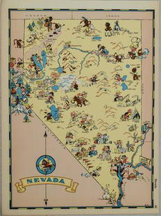
Sold20211938 R Taylor White Pictorial Map of Nevada -- NevadaTitle: 1938 R Taylor White Pictorial Map of Nevada -- Nevada Cartographer: Ruth Taylor White Year / Place: 1938, Boston Map Dimension (in.): 11.6 x 8.5 in. This is Ruth Taylor White's charming pictoriSee Sold Price
Sold20201938 R Taylor White Pictorial Map of Utah -- UtahTitle/Content of Map: 1938 R Taylor White Pictorial Map of Utah -- Utah Date: 1938, Boston Cartographer: Ruth Taylor White Size: 11.6 x 8.5 in. This is Ruth Taylor White's charming pictorial map, or cSee Sold Price
Sold20211938 R Taylor White Pictorial Map of Massachusetts --Title: 1938 R Taylor White Pictorial Map of Massachusetts -- Massachusetts Cartographer: Ruth Taylor White Year / Place: 1938, Boston Map Dimension (in.): 11.6 x 8.5 in. This is Ruth Taylor White's chSee Sold Price
May 16Potter & Potter AuctionsHANDY, R.D. (1879 – 1959). Paul Bunyan’s Pictorial Map of t...$200
May 16Potter & Potter AuctionsBOURNE, Emma (1906 – 1986). America – A Nation of One Peopl...$125(1 bid)
May 16Potter & Potter AuctionsCRAVATH, Glen (1897 – 1964). Py Your Leaf Baron Munchausen ...$80
May 16Potter & Potter Auctions[PICTORIAL MAPS – TRAVEL]. Three Pictorial Maps. 1940s/50s....$150
May 16Potter & Potter AuctionsSTORM, Mark. Official Texas Brags Map of North America. 194...$200(1 bid)
695 Lots AwayKey Date Coins1979 United States Mint Set in Original Government Packaging, 12 Coins Inside$10(1 bid)
2024Key Date Coins1979 United States Mint Set in Original Government Packaging, 12 Coins InsideSee Sold Price
21 hrs LeftKey Date Coins1979 United States Mint Set in Original Government Packaging, 12 Coins Inside$10


![1938 R Taylor White Pictorial Map of Hawaii and Samoa: Title: 1938 R Taylor White Pictorial Map of Hawaii and Samoa -- Territory of Hawaii [with] Samoa Cartographer: Ruth Taylor White Year/Place: 1938, Boston Size: 11.6 x 8.5 in. Description: This is Ruth](https://p1.liveauctioneers.com/5584/169916/85621317_1_x.jpg?height=310&quality=70&version=1591137604)
![1938 R Taylor White Pictorial Map of Hawaii and Samoa: Title/Content of Map: 1938 R Taylor White Pictorial Map of Hawaii and Samoa -- Territory of Hawaii [with] Samoa Date Printed: 1938, Boston Cartographer: Ruth Taylor White Size: 11.6 x 8.5 in. This is](https://p1.liveauctioneers.com/5584/117342/60336911_1_x.jpg?height=310&quality=70&version=1520389291)
![1938 R Taylor White Pictorial Map of Hawaii and Samoa -- Territory of Hawaii [with] Samoa: Title: 1938 R Taylor White Pictorial Map of Hawaii and Samoa -- Territory of Hawaii [with] Samoa Cartographer: Ruth Taylor White Year / Place: 1938, Boston Map Dimension (in.): 11.6 x 8.5 in. This is](https://p1.liveauctioneers.com/5584/274166/143946169_1_x.jpg?height=310&quality=70&version=1673389176)


![[PICTORIAL MAPS – TRAVEL]. Three Pictorial Maps. 1940s/50s.... (1 of 4)](https://p1.liveauctioneers.com/928/325952/175495561_1_x.jpg?height=282&quality=70&version=1712935174)


