Sold20201938 R Taylor White Pictorial Map of New Jersey -- NewTitle/Content of Map: 1938 R Taylor White Pictorial Map of New Jersey -- New Jersey Cartographer: Ruth Taylor White Year/Place: 1938, Boston Size: 11.6 x 8.5 in. This is Ruth Taylor White's charming pSee Sold Price
Sold20231938 R Taylor White Pictorial Map of New York -- New YorkTitle: 1938 R Taylor White Pictorial Map of New York -- New York Cartographer: Ruth Taylor White Year / Place: 1938, Boston Map Dimension (in.): 11.6 x 8.5 in. This is Ruth Taylor White's charming picSee Sold Price
Sold20201938 R Taylor White Pictorial Map of New Mexico -- NewTitle/Content of Map: 1938 R Taylor White Pictorial Map of New Mexico -- New Mexico Cartographer: Ruth Taylor White Year/Place: 1938, Boston Size: 11.6 x 8.5 in. This is Ruth Taylor White's charming pSee Sold Price
Sold20211938 R Taylor White Pictorial Map of New Hampshire --Title: 1938 R Taylor White Pictorial Map of New Hampshire -- New Hampshire Cartographer: Ruth Taylor White Year / Place: 1938, Boston Map Dimension (in.): 11.6 x 8.5 in. This is Ruth Taylor White's chSee Sold Price
Sold20181938 R Taylor White Pictorial Map of CaliforniaTitle/Content of Map: 1938 R Taylor White Pictorial Map of California -- California Date Printed: 1938, Boston Cartographer: Ruth Taylor White Size: 11.6 x 8.5 in. This is Ruth Taylor White's charmingSee Sold Price
Sold20181938 R Taylor White Pictorial Map of Florida -- FloridaTitle/Content of Map: 1938 R Taylor White Pictorial Map of Florida -- Florida Date: 1938, Boston Cartographer: Ruth Taylor White Size: 11.6 x 8.5 in. This is Ruth Taylor White's charming pictorial mapSee Sold Price
Sold20201938 R Taylor White Pictorial Map of Hawaii and SamoaTitle: 1938 R Taylor White Pictorial Map of Hawaii and Samoa -- Territory of Hawaii [with] Samoa Cartographer: Ruth Taylor White Year/Place: 1938, Boston Size: 11.6 x 8.5 in. Description: This is RuthSee Sold Price
Sold20181938 R Taylor White Pictorial Map of Hawaii and SamoaTitle/Content of Map: 1938 R Taylor White Pictorial Map of Hawaii and Samoa -- Territory of Hawaii [with] Samoa Date Printed: 1938, Boston Cartographer: Ruth Taylor White Size: 11.6 x 8.5 in. This isSee Sold Price
Sold20231938 R Taylor White Pictorial Map of Hawaii and Samoa -- Territory of Hawaii [with] SamoaTitle: 1938 R Taylor White Pictorial Map of Hawaii and Samoa -- Territory of Hawaii [with] Samoa Cartographer: Ruth Taylor White Year / Place: 1938, Boston Map Dimension (in.): 11.6 x 8.5 in. This isSee Sold Price
Sold20221938 R Taylor White Pictorial Map of Texas -- TexasTitle: 1938 R Taylor White Pictorial Map of Texas -- Texas Cartographer: Ruth Taylor White Year / Place: 1938, Boston Map Dimension (in.): 11.6 x 8.5 in. This is Ruth Taylor White's charming pictorialSee Sold Price
Sold20211938 R Taylor White Pictorial Map of Texas -- TexasTitle: 1938 R Taylor White Pictorial Map of Texas -- Texas Cartographer: Ruth Taylor White Year / Place: 1938, Boston Map Dimension (in.): 11.6 x 8.5 in. This is Ruth Taylor White's charming pictorialSee Sold Price
Sold20211938 R Taylor White Pictorial Map of the PhilippineTitle: 1938 R Taylor White Pictorial Map of the Philippine Islands -- Philippine Islands Cartographer: Ruth Taylor White Year / Place: 1938, Boston Map Dimension (in.): 11.6 x 8.5 in. This is Ruth TaySee Sold Price
Sold20181938 R Taylor White Pictorial Map of Colorado --Title/Content of Map: 1938 R Taylor White Pictorial Map of Colorado -- Colorado1938, Boston Cartographer: Ruth Taylor White Size: 8.5 11.6 in. This is Ruth Taylor White's charming pictorial map, or caSee Sold Price
Sold20181938 R Taylor White Pictorial Map of the PhilippineTitle/Content of Map: 1938 R Taylor White Pictorial Map of the Philippine Islands -- Philippine Islands Date Printed: 1938, Boston Cartographer: Ruth Taylor White Size: 11.6 x 8.5 in. This is Ruth TaySee Sold Price
Sold20181938 R Taylor White Pictorial Map of Kansas -- KansasTitle/Content of Map: 1938 R Taylor White Pictorial Map of Kansas -- Kansas Date: 1938, Boston Cartographer: Ruth Taylor White Size: 11.6 x 8.5 in. This is Ruth Taylor White's charming pictorial map,See Sold Price
Sold20181938 R Taylor White Pictorial Map of the Caribbean andTitle/Content of Map: 1938 R Taylor White Pictorial Map of the Caribbean and Central America -- This Map locates the Panama Canal Zone, Porto Rico and Virgin Islands in Central America and the West InSee Sold Price
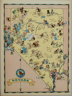
Sold20211938 R Taylor White Pictorial Map of Nevada -- NevadaTitle: 1938 R Taylor White Pictorial Map of Nevada -- Nevada Cartographer: Ruth Taylor White Year / Place: 1938, Boston Map Dimension (in.): 11.6 x 8.5 in. This is Ruth Taylor White's charming pictoriSee Sold Price
Sold20201938 R Taylor White Pictorial Map of Utah -- UtahTitle/Content of Map: 1938 R Taylor White Pictorial Map of Utah -- Utah Date: 1938, Boston Cartographer: Ruth Taylor White Size: 11.6 x 8.5 in. This is Ruth Taylor White's charming pictorial map, or cSee Sold Price
Sold20211938 R Taylor White Pictorial Map of Massachusetts --Title: 1938 R Taylor White Pictorial Map of Massachusetts -- Massachusetts Cartographer: Ruth Taylor White Year / Place: 1938, Boston Map Dimension (in.): 11.6 x 8.5 in. This is Ruth Taylor White's chSee Sold Price
Sold20201938 R Taylor White Pictorial Map of North Carolina --Title: 1938 R Taylor White Pictorial Map of North Carolina -- North Carolina Date: 1938, Boston Cartographer: Ruth Taylor White Size: 11.6 x 8.5 in. Additional Information: This is Ruth Taylor White'sSee Sold Price
Sold20201938 R Taylor White Pictorial Map of Georgia -- GeorgiaTitle/Content of Map: 1938 R Taylor White Pictorial Map of Georgia -- Georgia Cartographer: Ruth Taylor White Year/Place: 1938, Boston Size: 11.6 x 8.5 in. This is Ruth Taylor White's charming pictoriSee Sold Price
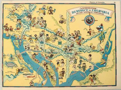
Sold20211938 R Taylor White Pictorial Map of Washington D.C. --Title: 1938 R Taylor White Pictorial Map of Washington D.C. -- Washington District of Columbia the National Capital Cartographer: Ruth Taylor White Year / Place: 1938, Boston Map Dimension (in.): 11.6See Sold Price
Sold20211938 R Taylor White Pictorial Map of the United StatesTitle: 1938 R Taylor White Pictorial Map of the United States -- The United States of America Cartographer: Ruth Taylor White Year / Place: 1938, Boston Map Dimension (in.): 11.6 x 8.5 in. This is RutSee Sold Price
Sold20191938 R Taylor White Pictorial Map of Michigan --Title/Content of Map: 1938 R Taylor White Pictorial Map of Michigan -- Michigan Date: 1938, Boston Cartographer: Ruth Taylor White Size: 11.6 x 8.5 in. This is Ruth Taylor White's charming pictorial mSee Sold Price
6 days LeftJasper521775-1780. New York, New Jersey, Pennsylvania, Maryland, Virginia and New England states. By Bonne &$120
May 16Potter & Potter AuctionsBATE, Neel (1916 – 1989). Jimmy and Sally in Mother Goose L...$200
783 Lots AwayMynt AuctionsLawrence Taylor Autographed White Pro Style Jersey w/HOF- Beckett W *Silver *6$10
3 days LeftBucklinIshioka, Eiko; Coppola, Francis Ford; Eiko On Stage [RARE 2000 CALLOWAY FIRST EDITION - FINE COPY]$60(2 bids)
4 days LeftTremont Auctions18th century map of New Jersey. "A New and Accurate Map of New Jersey". W. Long, London. Map size 13$100


![1938 R Taylor White Pictorial Map of Hawaii and Samoa: Title: 1938 R Taylor White Pictorial Map of Hawaii and Samoa -- Territory of Hawaii [with] Samoa Cartographer: Ruth Taylor White Year/Place: 1938, Boston Size: 11.6 x 8.5 in. Description: This is Ruth](https://p1.liveauctioneers.com/5584/169916/85621317_1_x.jpg?height=310&quality=70&version=1591137604)
![1938 R Taylor White Pictorial Map of Hawaii and Samoa: Title/Content of Map: 1938 R Taylor White Pictorial Map of Hawaii and Samoa -- Territory of Hawaii [with] Samoa Date Printed: 1938, Boston Cartographer: Ruth Taylor White Size: 11.6 x 8.5 in. This is](https://p1.liveauctioneers.com/5584/117342/60336911_1_x.jpg?height=310&quality=70&version=1520389291)
![1938 R Taylor White Pictorial Map of Hawaii and Samoa -- Territory of Hawaii [with] Samoa: Title: 1938 R Taylor White Pictorial Map of Hawaii and Samoa -- Territory of Hawaii [with] Samoa Cartographer: Ruth Taylor White Year / Place: 1938, Boston Map Dimension (in.): 11.6 x 8.5 in. This is](https://p1.liveauctioneers.com/5584/274166/143946169_1_x.jpg?height=310&quality=70&version=1673389176)


![Ishioka, Eiko; Coppola, Francis Ford; Eiko On Stage [RARE 2000 CALLOWAY FIRST EDITION - FINE COPY] (1 of 14)](https://p1.liveauctioneers.com/8658/325945/175541737_1_x.jpg?height=282&quality=70&version=1712964944)


