Sold20201956 Pan Am World and Germany Route Map -- WillkommenTitle: 1956 Pan Am World and Germany Route Map -- Willkommen an Bord! Pan Am Cartographer: Pan American Airways Year / Place: 1956 Map Dimension (in.): 15.3 X 8.3 in. A very nice pictorial map of theSee Sold Price
Sold2019Pan American Airways System. World Map 1956.Pan American Airways System. World Map 1956. Art by John Brown, cartography by John Philip. Offset poster showing the airline’s routes across the world. 34 x 60”. Inpainting to lower image, minorSee Sold Price
Sold20231950s Pan Am World Route Maps -- Route Maps Pan AmericanTitle: 1950s Pan Am World Route Maps -- Route Maps Pan American Cartographer: PanAm Year / Place: late 1950s c. Map Dimension (in.): 9 x 12 in. single page This is an outstanding 6 double page fold-ouSee Sold Price
Sold2018Pan American Airways System. World Map 1968Pan American Airways System. World Map 1968. Art by John Brown, cartography by John Philip. Offset poster showing the airline's routes across the world. Linen backed. 18 x 32". A.See Sold Price
Sold20201950s PanAm Route Map of Caribbean -- Pan AmericanTitle/Content of Map: 1950s PanAm Route Map of Caribbean -- Pan American Flight Map of New York and Caribbean Cartographer: PanAm Year/Place: late 1950s c. Size: 24 X 14 in. folded out A very nice rouSee Sold Price
Sold20221950s PanAm Route Map of Caribbean -- Pan American Flight Map of New York and CaribbeanTitle: 1950s PanAm Route Map of Caribbean -- Pan American Flight Map of New York and Caribbean Cartographer: PanAm Year/Place: late 1950s c. Dimensions: 24 X 14 in. folded out Description: A very niceSee Sold Price
Sold20231950s PanAm Route Map of South America's East Coast -- Pan American Flight Map, South America EastTitle: 1950s PanAm Route Map of South America's East Coast -- Pan American Flight Map, South America East Coast Cartographer: PanAm Year / Place: late 1950s c. Map Dimension (in.): 23.5 X 16.8 in. folSee Sold Price
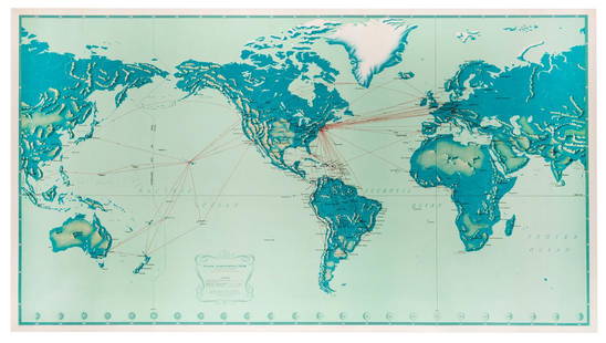
Sold20181947 World Route Map of US Flag Airlines --Title/Content of Map: 1947 World Route Map of US Flag Airlines -- International Air Routes of U.S. Flag Carriers as of April, 1947 Date: 1947 Cartographer: Anonymous Size: 10.9 x 21 in. This fascinatiSee Sold Price
Sold20191950s PanAm Route Map of Caribbean -- PanAmericanTitle/Content of Map: 1950s PanAm Route Map of Caribbean -- PanAmerican Flight Map of New York and Caribbean Date: late 1950s c. Cartographer: PanAm Size: 14x 24 in. folded out A very nice route map oSee Sold Price
Sold20221950s PanAm Route Map of Caribbeanan -- PanAmerican Flight Map of New York and CaribbeananTitle: 1950s PanAm Route Map of Caribbeanan -- PanAmerican Flight Map of New York and Caribbeanan Cartographer: PanAm Year / Place: late 1950s c. Map Dimension (in.): 14x 24 in. folded out A very niceSee Sold Price
Sold20211950s PanAm Route Map of Caribbeanan -- PanAmericanTitle: 1950s PanAm Route Map of Caribbeanan -- PanAmerican Flight Map of New York and Caribbeanan Cartographer: PanAm Year / Place: late 1950s c. Map Dimension (in.): 14x 24 in. folded out A very niceSee Sold Price
Sold20181950s PanAm Route Map of Caribbeanan -- PanAmericanTitle/Content of Map: 1950s PanAm Route Map of Caribbeanan -- PanAmerican Flight Map of New York and Caribbeanan Date: late 1950s c. Cartographer: PanAm Size: 14x 24 in. folded out A very nice route mSee Sold Price
Sold20191950s PanAm Route Map of Caribbean -- PanAmericanTitle/Content of Map: 1950s PanAm Route Map of Caribbean -- PanAmerican Flight Map of New York and Caribbean Date: late 1950s c. Cartographer: PanAm Size: 14x 24 in. folded out A very nice route map oSee Sold Price
Sold20181950s PanAm Route Map of Caribbeanan -- PanAmericanTitle/Content of Map: 1950s PanAm Route Map of Caribbeanan -- PanAmerican Flight Map of New York and Caribbeanan Date: late 1950s c. Cartographer: PanAm Size: 14x 24 in. folded out A very nice route mSee Sold Price
Sold20231950s PanAm Route Map of Caribbeanan -- PanAmerican Flight Map of New York and CaribbeananTitle: 1950s PanAm Route Map of Caribbeanan -- PanAmerican Flight Map of New York and Caribbeanan Cartographer: PanAm Year / Place: late 1950s c. Map Dimension (in.): 14x 24 in. folded out A very niceSee Sold Price
Sold20231950s PanAm Route Map of Caribbean with Personal Notations -- PanAmerican Flight Map of New York andTitle: 1950s PanAm Route Map of Caribbean with Personal Notations -- PanAmerican Flight Map of New York and Caribbean Cartographer: PanAm Year / Place: late 1950s c. Map Dimension (in.): 14x 24 in. foSee Sold Price
Sold2018PanAm: Vintage Route Map of Caribbean, 1950sTitle/Content of Map: 1950s PanAm Route Map of Caribbean -- PanAmerican Flight Map of New York and Caribbeanan Date Printed: 1950s c. Cartographer: PanAm Size: 14 x 24 in. folded out A very nice routeSee Sold Price
Sold2022Pan American Clipper Club World Pushpin MapLarge Framed Pan American World Map which reads “Be it witnessed and Known The Clipper travel on this map is that flown by Joel Bonsall distinguished member of the Pan Am Clipper Club” witSee Sold Price
Sold20201930 Japanese Mainichi Newspaper World Air RouteTitle: 1930 Japanese Mainichi Newspaper World Air Route Pictorial Map -- Conquer Sky Sugoroku [World Air Route Map] Cartographer: Mainichi Newspaper Year / Place: 1930, Osaka Map Dimension (in.): 26.8See Sold Price
Sold2018PanAM: Vintage Pictorial World Map, 1957Title/Content of Map: 1957 PanAM Pictorial World Map -- Your Clipper Cargo Market Area Date Printed: 1957 c. Cartographer: PanAm Size: 22 x 34 in. A very interesting world map showing PanAm cargo routSee Sold Price
Sold2023Group of 18 Pan Am Airline Route Maps and MenusIncludes Rainbow Service menus, Some large tears in maps, Largest map measures 9 x 12in folded.See Sold Price
Sold2023PAN AMERICAN AIRLINES ROUTE MAP. "Fastest way between… USA & Latin America" 1935Title: PAN AMERICAN AIRLINES ROUTE MAP. "Fastest way between… USA & Latin America" 1935 Description: Consult this map for fastest way between all points in the United States and Latin America' bSee Sold Price
Sold2018American Airlines Route Map World's Fair Line 1939American Airlines Route Map World's Fair Line 1939See Sold Price
Sold2022Vintage Air France Airline Travel Routes World MapVintage Air France Airline Travel Routes World Map, by Lucien Boucher (French, 1889-1971) color offset, C.1948. Framed. Size: 19.5'' x 33.75'', 50 x 86 cm (sight); 24.5'' x 39'', 62 x 99 cm (frame).See Sold Price
May 14Akiba Galleries(2 Pc) Allain Manesson Mallet Description De L'Univers 2 Vol. German Translation$200(1 bid)
6 days LeftRail & Road Auctions1956 Great Lakes Vacation Cruises Brochure and Three Steamship Photographs$20
5 days LeftHunt and Peck Estate Services, Inc.William Hole "A Description of the land of Gosen, and Moses passage though the Deserts"$50
4 days LeftJasper521753 Prevost Map of Pacific Wind Currents -- Representation du Cours ordinaire des Vents de Traverse$85
6 hrs LeftTrillium Antique Prints & Rare BooksBraun & Hogenberg, pub. 1575 - View of Innsbruck, Germany$100(1 bid)
5 hrs LeftMatthew Bullock Auctioneers1964 Hasbro G.I. Joe Soldiers of the World German Action Figure$120(3 bids)
2 days LeftMynt Auctions1956 World Champion Yankees 16X20 Photo from Original Negative Mantle 147175$10
1073 Lots AwayMynt AuctionsYogi Berra & Don Larsen 1956 World Series Perfect Game Signed 8x10 Photo JSA COA$200


![1930 Japanese Mainichi Newspaper World Air Route: Title: 1930 Japanese Mainichi Newspaper World Air Route Pictorial Map -- Conquer Sky Sugoroku [World Air Route Map] Cartographer: Mainichi Newspaper Year / Place: 1930, Osaka Map Dimension (in.): 26.8](https://p1.liveauctioneers.com/5584/187575/94368587_1_x.jpg?height=310&quality=70&version=1607465981)


