20241962 Braniff Airways Pictorial Route Map -- Fly Braniff International AirwaysTitle: 1962 Braniff Airways Pictorial Route Map -- Fly Braniff International Airways Cartographer: Braniff Year / Place: 1962 Map Dimension (in.): 11 x 8 in. A nice route map of now discontinued BraniSee Sold Price
Sold2015Braniff International Airways Desk Model.Includes original stand marked Jet Power Electra Braniff Airways. Built by Lockheed. Four prop plane. Done in heavy metal. Nice decals on sides which say Braniff International Airways and fly BraniffSee Sold Price
Sold2018Braniff Airlines: Vintage Map of Americas Routes, 1944Title/Content of Map: 1944 Braniff Airlines Americas Routes -- Braniff Airlines Americas Routes Date Printed: 1944 Cartographer: Braniff Airlines Size: 10 x 7 in. An excellent and off-beat Braniff airSee Sold Price
Sold2020Braniff International Airways. Paraguay.Braniff International Airways. Paraguay. Circa 1950s. A colorful silkscreen depicting a woman carrying a basket and wearing a montera as a Braniff jet flies overhead. 26 x 20”. Light inpaintingSee Sold Price
Sold2022Pair of pictorial airline poster maps of Great Britain. Inc...Pair of pictorial airline poster maps of Great Britain. Including: TAVENER. A Literary Map of Britain / Fly There by B.O.A.C. 1962. Poster airline map of Great Britain depicting numerous literary persSee Sold Price
Sold2023Fly CAT / See Taiwan. Government Information Office, Republ...Fly CAT / See Taiwan. Government Information Office, Republic of China, ca. 1960s. Pictorial airline travel poster map of Taiwan. CAT’s routes and airports are marked with pink lines and red dotSee Sold Price
Sold2016Erin (dates unknown) Imperial Airways Routes Map,Erin (dates unknown) Imperial Airways Routes Map, printed by Curwen Press May 1938 - 63 x 101 cm; and Imperial Airways Alexandria - Durban, Booklet containing maps of route taken by Flying Boats, withSee Sold Price
Sold20211962 Pictorial Map of Ohio in the War of 1812 -- OhioTitle: 1962 Pictorial Map of Ohio in the War of 1812 -- Ohio in the War of 1812 Prepared by the Anthony Wayne Parkway Board 1962 Cartographer: Anthony Wayne Parkway Board Year / Place: 1962 Map DimensSee Sold Price
Sold20221960 Hawaiian Airlines Pictorial Route Map -- The Hawaiian IslandsTitle: 1960 Hawaiian Airlines Pictorial Route Map -- The Hawaiian Islands Cartographer: Hawaiian Airlines Year / Place: 1960 Map Dimension (in.): 8.9 X 20.2 in This is an attractive pictorial airlineSee Sold Price
Sold2018KAC Kuwait Airways Route Map Circa 1975KAC Kuwait Airways route map, circa 1975. 35"x17"See Sold Price
Sold2021Color pictorial bird's-eye airline route maps 1929Heading: (Aviation - pictorial route maps) Author: Title: Western Air Express: Travel by Air, Speed - Comfort - Dependability Place Published: [California?] Publisher:Western Air Express Date PuSee Sold Price
Sold2018Air France. Large World Map Airways Route Poster.Masse, Jean. Air France. Large World Map Airways Route Poster. Paris: R. Graindorge/Perceval, ca. 1961. Color map of the world detailing the airline's routes. Linen backed. 45 ½ x 81". Small browSee Sold Price
Sold20201930 Japanese Mainichi Newspaper World Air RouteTitle: 1930 Japanese Mainichi Newspaper World Air Route Pictorial Map -- Conquer Sky Sugoroku [World Air Route Map] Cartographer: Mainichi Newspaper Year / Place: 1930, Osaka Map Dimension (in.): 26.8See Sold Price
Sold2018Pan American Airways Circa 1950's System Route MapPan American Airways Circa 1950's System Route MapSee Sold Price
Sold2015Braniff International Airways Travel Agency Model.This model plane is heavy cast metal with all original decals. There are paint chips on the ends of the wings, the tip of the tail and the tip of the nose. Minor scattered wear else where. This is a nSee Sold Price
Sold2020Alexander Girard for Herman Miller sofaAlexander Girard (1907-1993) for Herman Miller sofa, #66303 Zeeland, Michigan, 1967 Alexander Girard upholstery, aluminum, vinyl applied metal label to leg: 'Braniff International Airways Property No.See Sold Price
Sold2023ALEXANDER CALDER (AMERICAN, 1898-1976)Alexander CalderAmerican, 1898-1976Flying Colors, 1974Lithographs in colors on wove paper, signed with blind stampThe suite from the portfolio designed for Braniff International Airways of six (6) witSee Sold Price
Sold2018United Airlines Route Map A Gay Geography of Main LineUnited Air Lines. A Gay Geography of the Main Line Airway. The Main Line Mid-Continental Airway published in 1939 route map. See Sold Price
Sold2022Sabena Belgian World Airways / Holiday Abroad ExtraSabena Belgian World Airways / Holiday Abroad Extra City Plans. 1961-62. A pictorial map of Europe is covered in small illustrations of important buildings and cities, bordered by the 1961-62 calendarSee Sold Price
Sold2021Lewis and Clark Journals 1962 Limited Ed. ClubLewis and Clark Journals 1962 with maps. This is a two volume set with slipcase. The Limited Editions Club New York. Numbered '757' of 1500. 772 pp. Many color illustrations. Pictorial map covers. ExSee Sold Price
Sold20201956 Pan Am World and Germany Route Map -- WillkommenTitle: 1956 Pan Am World and Germany Route Map -- Willkommen an Bord! Pan Am Cartographer: Pan American Airways Year / Place: 1956 Map Dimension (in.): 15.3 X 8.3 in. A very nice pictorial map of theSee Sold Price
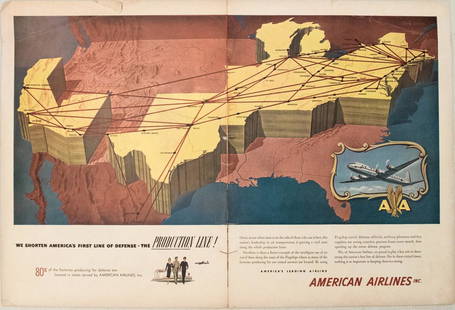
Sold20231950s American Airlines Route Map -- American Airlines Route MapTitle: 1950s American Airlines Route Map -- American Airlines Route Map Cartographer: American Airlines Year / Place: 1950s Map Dimension (in.): 12.5 X 19.2 in. joined This nice, large pictorial routeSee Sold Price
Sold20181961 Panagra / PanAm Pictorial Map of South AmericanTitle/Content of Map: 1961 Panagra / PanAm Pictorial Map of South American Air Routes -- The Only Jet Service 'Round South America Date: 1961 Cartographer: PanAm Size: 10.5 x 8 in. A nice air Route MaSee Sold Price
Sold2023Sixteen Northern Railroad Timetables and Map - 1911 to 1967 Northern Pacific and Great NorthernA group of sixteen northern railroad timetables and a map spanning 1911 to 1967. Five Northern Pacific tables dated 1915, 1959, 1962, and 1967. A Great Northern Railway foldout route map and ten tableSee Sold Price
2 days LeftJasper521970s Hawaiian Airlines Pictorial Route Map -- Hawaiian Airlines Map of the Hawaiian Islans$35
5 days LeftRail & Road AuctionsMixed Group of Twelve Airline Timetables - Frontier, Eastern, Southern, Texas International, and$20
2 days LeftJasper521960 Alaska Cruise Lines Pictorial Map of Alaska -- State of Alaska Visitor's Map$30
5 days LeftRail & Road AuctionsNine Braniff International Airways Paper Items - First Class Menu, Silver Service Menu with Llama$40
5 days LeftRail & Road AuctionsThree Airline Promotional Advertising Lighters - Braniff International Airways, Air India, and WIN$40
5 days LeftRail & Road AuctionsNine United Air Lines Paper Items - Travel Brochures, Guides, Maps, Information Packet, Flight Log,$30
May 16Potter & Potter AuctionsPictorial Map of Hollywood and Vicinity / Hollywood Film Ca...$125(1 bid)
May 16Potter & Potter AuctionsHANDY, R.D. (1879 – 1959). Paul Bunyan’s Pictorial Map of t...$200
May 16Potter & Potter Auctions[NEW YORK CITY – PICTORIAL MAPS]. Group of 3 pictorial maps...$200(1 bid)


![Color pictorial bird's-eye airline route maps 1929: Heading: (Aviation - pictorial route maps) Author: Title: Western Air Express: Travel by Air, Speed - Comfort - Dependability Place Published: [California?] Publisher:Western Air Express Date Pu](https://p1.liveauctioneers.com/642/204898/103985846_1_x.jpg?height=310&quality=70&version=1621652446)

![1930 Japanese Mainichi Newspaper World Air Route: Title: 1930 Japanese Mainichi Newspaper World Air Route Pictorial Map -- Conquer Sky Sugoroku [World Air Route Map] Cartographer: Mainichi Newspaper Year / Place: 1930, Osaka Map Dimension (in.): 26.8](https://p1.liveauctioneers.com/5584/187575/94368587_1_x.jpg?height=310&quality=70&version=1607465981)


![[NEW YORK CITY – PICTORIAL MAPS]. Group of 3 pictorial maps... (1 of 3)](https://p1.liveauctioneers.com/928/325952/175495562_1_x.jpg?height=282&quality=70&version=1712935174)