Sold20232 Framed Maps of Canada & U.S.Group of two framed maps depicting Canada and the United States. One map depicting the East Coast of the United States as well as southeastern Canada. One map depicting Lake Superior and south-centralSee Sold Price
Sold2023ANTIQUE FLORIDA FRAMED MAPS - LOT OF 2148268 ANTIQUE FLORIDA FRAMED MAPS - LOT OF 2 Antique Florida map framed map to include one 1853 U.S. Coast Survey Chart or Map of St. George's Sound, Florida, and one unsigned map of Florida denotedSee Sold Price
Sold2016Lithographed Map of Oregon, 1866Oregon. U.S. General Land Office. hand-colored Lithograph. New York: Major & Knapp, c. 1866. 17 1/2 x 23 inches sheet, 27 x 32 1/2 inches framed. This map shows the state of Oregon seven years after sSee Sold Price
Sold2017J.T. Lloyd Wall Map of U.S. & Canada"Lloyds New Map of the United States, the Canadas and New Brunswick" dated 1863. 39" high, 57 1/2" wide. Toned throughout, scattered edge losses and small tears, tear with old tape repair upper left,See Sold Price
Sold20222 Early American History Books1777 Introduction to the History of America (has foldout Map of US and Canada), 1834 History of United States of America by Charles A. Goodrich. 1777 Book in Good condition, slight page discoloration,See Sold Price
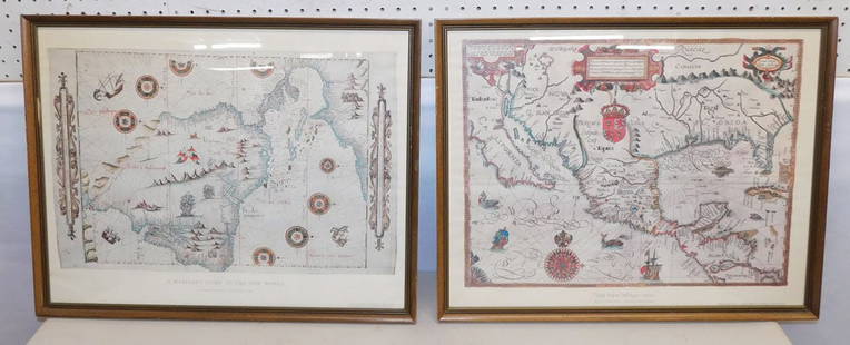
Sold2023Giambattista Albrizzi. Two Maps of North America(Italian, 1698-1777). Map of North America and map of Canada and the Great Lakes, 1740, engravings, sight size of each: 13 1/2 x 17 in., both framed.See Sold Price
Sold2018Carte De La Nouvelle France (Map of New France)Carte De La Nouvelle France (Map of New France / Canada). Framed Size: 24 1/2" x 22". Fine full color example of Henri Chatelain's map of the inhabited parts of North America, based upon Nicholas De FSee Sold Price
Sold20232 Travel Maps of US: Atwood Pocket Map 1851 & Williams Framed, 18541st item: PHELPS'S NATIONAL MAP OF THE UNITED STATES, TRAVELLERS GUIDE. EMBRACING THE PRINCIPAL RAIL ROADS, CANALS, STEAM BOAT & STAGE ROUTES THROUGHOUT THE UNION, by J. M. Atwood, published by ThayerSee Sold Price
Sold2015Chez Pierre Vander, "Nouvelle France," MapChez Pierre Vander, "Nouvelle France," hand colored early map of Canada, matted and framed, 10" h x 15" w (view), 15 1/2" h x 20" w (frame). Provenance: From a Massachusetts estate.See Sold Price
Sold2022Framed Map of Hudson River Days Pt. GW BridgeFramed Map of Hudson River Days Pt. GW Bridge, published by the U.S. Department of Commerce National oceanic and atmospheric administration national ocean survey, Measures 29 x 41 1/2 inches, gold tonSee Sold Price
Sold2018MAPS: (2) U.S. Regional 1846 Meyer's AtlasMAPS: (2) U.S. Regional 1846 Meyer's Atlas, Pair of United States regional maps. Framed, sizes given are area inside mat followed by overall framed size. Both from Meyer's Universal Atlas and marked SSee Sold Price
Sold2019Marc Selva, US / Canada Listed Artist Modernism VillageMarc Selva, US / Canada Listed Artist Modernism Village, oil on canvas painting, signed, framed, nice quality, well listed artist. ; 18 x 21 1/2 inches image, 25 1/4 x 19 1/4 inches outside frame.ASKaSee Sold Price
Sold2017Florida Lithograph MapU.S. Coast Survey Sketch F Showing the Progress of the Survey in Section V. A.D. Bache (1806-1867). Lithographed map. Washington, D.C., 1855. 23 x 16 1/2 inches visible, 27 1/4 x 21 1/2 inches framedSee Sold Price
Sold2020FRAMED ANTIQUE MAP OF THE WORLDFRAMED ANTIQUE MAP OF THE WORLD, ROBERT DE VAUGONDY, ORBIS VET US, 1752, GEOGRAPHO REGIS ORDINARIO. PAPER IS ACID BURNED AND FOLDED IN THE CENTER. Height: 27 & 19 1/2 in. by Width: 36 1/2 & 29 in.See Sold Price
Sold20231865 Colton's RR and Military Map of the US1865 "Colton's Railroad & Military Map of the United States", folding pocket map laid down on board, framed, some toning from oxidation, 32 1/2" x 42"See Sold Price
Sold2021MAP OF NOVA SCOTIA DE VAUGONDYBrilliant hand colored map of Nova Scotia, depicting Port Royal, the oldest European settlement in Canada. Professionally framed and matted. In frame 13 1/4"x12 1/4"x1/2". Weight 1 pd 9 oz. Gilles RobSee Sold Price
Sold20231778 J. Lodge Exact Map of the Five Great Lakes1778 Lodge Exact Map of the Five Great Lakes with Part of Pensilvania New York, Canada and Hudson's Bay Territories from the best Surveys. Hand colored, fine framed acid free mount example. 8 1/2 by 1See Sold Price
Sold2017Florida Lithograph MapA Plat Exhibiting The State of the Surveys in the State of Florida. US Surveyor General. Lithograph. Washington D.C. : 1855. 22 1/2 x 26 inches visible, 35 x 38 inches framedSee Sold Price
Sold2015Lot of 2 framed mapsNovi Begii map of New England & Map of the Worls by Nicholas Visscher. 24"h x 27"w framed.See Sold Price
Sold20232 FRAMED MAPS, 1723 SO. AMERICA & THE ROMAN ROADS OF BRITIAN (24 1/2" X 20")2 FRAMED MAPS, 1723 SO. AMERICA & THE ROMAN ROADS OF BRITIAN (24 1/2" X 20")See Sold Price
Sold2022(2) Framed U.S. Schooner Battleships and Soldiers WatercolorsOne depicting U.S. soldiers rowing towards battleships flying the American flag and one with soldiers on horseback. Measuring approx. 18.5" tall by 16" wide. Framed and matted with no signatures visibSee Sold Price
Sold20232 Framed Maps2 Framed Maps . 25" X 19 3/4" ALL DESCRIPTIONS AND ANY CONDITION STATEMENT GIVEN BY LANGSTON AUCTION GALLERY ARE STRICTLY OPINIONS AND LANGSTON'S SHALL HAVE NO RESPONSIBILITY FOR ERRORS OR OMISSIONS.See Sold Price
Sold20212 FRAMED MAPSTWO FRAMED MAPS INCLUDING EASTON PA, PHILLIPSBURG. LARGEST MAP HAS DAMAGE TO UPPER LEFT & NO GLASS BY SW ROCKWELL. 36 3/4 IN X 37 1/2 IN INCLUDING FRAMESee Sold Price
4 days LeftJasper521884 Rand McNally Map of US Railroad System -- Map Exhibiting the Several Pacific Railroads Prepared$140
1 day LeftTremont Auctions1778 "Il Canada" original map depicting Canada and the US. Hand colored. Fold down center. Framed.$225(2 bids)
6 days LeftMynt AuctionsWayne Gretzky Signed Autographed Framed Photo 2010 Canada Olympic Torch /199$10
6 days LeftHunt and Peck Estate Services, Inc.Jacques Nicolas Bellin Map Of Western Part Of New France Or Canada$200(1 bid)
6 days LeftHunt and Peck Estate Services, Inc.1849 Alex Mackay 1st US Ed. 2 Vol. "The Western World or Travels in the United States in 1846-1847"$50
6 days LeftHunt and Peck Estate Services, Inc.1926 James Elroy Flecker 1st US Edition "The King of Aslander"$50
3 days LeftBidhausPresident Theodore Roosevelt Signed Appointment Document Custom Framed JSA LOA 2$10