Sold2018MAPS: (2) U.S. Regional 1846 Meyer's AtlasMAPS: (2) U.S. Regional 1846 Meyer's Atlas, Pair of United States regional maps. Framed, sizes given are area inside mat followed by overall framed size. Both from Meyer's Universal Atlas and marked SSee Sold Price
Sold2018(2) U.S. MAPS & AN ATLASIncluding: "Huntington's School Atlas, Drawn and Engraved expressly to Illustrate and Accompany The System of Modern Geography" by G. Huntington, A.M. Third Edition, 1853. Hartford, Published by R. WhSee Sold Price
Sold20181850 Meyer Mid-continent statesReserve Reduced! Scarce regional map of the upper Midwest from Meyer's Zeitungs-Atlas. Minnesota still labeled as Sioux Territory. Highly detailed map shows towns, rivers, lakes, roads, railroads, canSee Sold Price
Sold2018Radefeld/Meyer: Antique Map of U.S. & Mexico, 1852Vereinigte Staaten von Nord-America und Mexico. A highly detailed map of the United States and Mexico from Meyer's Groschen-Atlas, showing the pre-Gadsen Purchase border between the U.S. and Mexico anSee Sold Price
Sold20163 Maps Total , 1 of Tennessee, 2 of Kentucky andThree (3) Maps, 1 of Tennessee, 2 of Kentucky and Tennessee. 1st item: "A New Map of Tennessee" by Samuel Augustus Mitchell from his "A New Universal Atlas" 1846. Colored map featuring Tennessee dividSee Sold Price
Sold2016George Cram: Nova Scotia Map Plate 2, 1891Map: Nova Scotia Plate 2 Maker: George Cram Date: 1891 Size: 21.75 x 13.5 inches For "The Home Knowledge Atlas" George F. Cram (1842-1928) served in the U.S. Army during the American Civil War. AfterSee Sold Price
Sold2021Connecticut, 1846, with Hartford & New Haven InsetsTitle/Content of Map: Connecticut, 1846, with Hartford & New Haven Insets Date Printed: 1846, Hildburghausen Cartographer: Joseph Meyer/Bibliographisches Instituts. Size: 14 1/2" 11 3/4" The beautifulSee Sold Price
Sold2020Map of U.S., 1846*** START PRICE IS THE RESERVE *** [America] HAVEN & EMMERSON. Map of the United States and Mexico Including Oregon, Texas and the Californias. Engraved map with original hand color. New York, 1846. 1See Sold Price
Sold2018LARGE LOT ASSORTED US ATLAS MAP PAGES INCLUDINGLARGE LOT ASSORTED US ATLAS MAP PAGES INCLUDING JOHNSON'S CYCLOPEDIA, 19/20TH CENTURYSee Sold Price
Sold2018LARGE LOT ASSORTED US ATLAS MAP PAGES INCLUDINGLARGE LOT ASSORTED US ATLAS MAP PAGES INCLUDING MITCHELL'S CYCLOPEDIA, 19/20TH CENTURYSee Sold Price
Sold2021Cuba, Jamaica and San DomingoPublication Date: 1887 Title: Cuba, Jamaica and San Domingo Cartographer: CRAM, GEORGE F. Publisher: A.A. Grant Height: 15.75 Width: 22.25 "Engraved expressly for the Standard World atlas." Regional mSee Sold Price
Sold2018MAPS: (2) 1851 Rapkin Tallis U.S. & N. AmericaMAPS: (2) 1851 Rapkin Tallis U.S. & N. America, Pair of maps Drawn & Engraved by J. Rapkin, published by J & F Tallis, London, Edinburgh & Dublin, with illustrations by J. Marchant engraved by J. RogeSee Sold Price
Sold2017SDUK: Antique Map of US Gulf Coast, 1846Title/Content of Map: 'NORTH AMERICA, SHEET XIII., Parts of Louisiana, Arkansas, Mississippi, Alabama & Florida' Native American settlements are named on the map west of the Mississippi, some marked wSee Sold Price
Sold20191873 A.T. Andreas Atlas U.S. Topographical MapPrinted in blue and brown ink with hand colored borders. Atlas charts and information to reverse. Very good condition; age toning, etc. Center fold as issued. 17.25" x 27.5" approx.See Sold Price
Sold20212 U.S. Coast Survey Maps, Catalina Harbor & West CoastLot of two U.S. Coast Survey Maps to include: Catalina Harbor, "1852" and Reconnaissance of the Western Coast of the United States, middle sheet, from San Francisco to the Umpquah River, "1854," frameSee Sold Price
Sold2022Lot Of 2 Tire Holder Sides U.S. Royal & AtlasHave above average-average color and gloss, show wear, discoloration, paint loss, and a few dings, 7.5"x23", rated 8-7.75See Sold Price
Sold2016Larry Hadlock Jigsaw PuzzlesLarge assortment of tiny wooden jigsaw puzzles in original packaging with two maps of the U.S. 2" X 3", whales, eagle, wolf, etc. 17 puzzles in all.See Sold Price
Sold2016Carte Des Etats-Unis, 1856Map: Carte Des Etats-Unis Maker: Louis Etienne Dussieux Date: 1856 Size: Folio - 11 inches high x 15.25 inches wide "Grave par Marlier." U.S. map from his Atlas Generale showing unusual Western territSee Sold Price
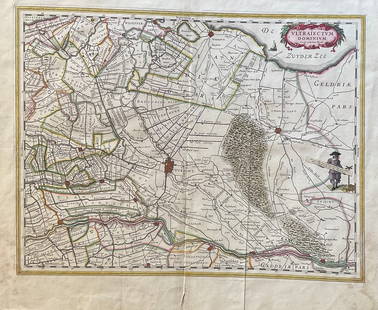
Sold2023The Netherlands Map. The region Around the city of Utrecht. 1660?s by W. BlaeuTitle: The Netherlands Map. The region Around the city of Utrecht. 1660?s by W. Blaeu Date/Period: 1660?s Materials: Hand colored copper plate engraved Size: 22 x 19 1/2'' Netherlands regional map cenSee Sold Price
Sold2018Meyer: Map of Connecticut/Hartford, New Haven insetsConnecticut The beautifully detailed and colored map of Connecticut from Meyer's Auswanderungs-Atlas (Emigrant's Atlas). Includes a key to canals, railroads, roads and paths and lists of county and coSee Sold Price
Sold2018Meyer/J. Graessl.: Mississippi, 1852The beautifully detailed and colored map of Mississippi from Meyer's Auswanderungs-Atlas (Emigrant's Atlas) of North America, with county borders and many place names and topographical details; RS2190See Sold Price
Sold2018Graessl.: Antique County Map of Iowa, 1849Karte von Iowa 1853 The beautifully detailed and colored map of Iowa from Meyer's Auswanderungs-Atlas (Emigrant's Atlas) of North America, with its counties clearly named. Cartographer: J. Graessl. /See Sold Price
Sold2018Meyer/J. Graessl.: Iowa, 1852The beautifully detailed and colored map of Iowa from Meyer's Hand-Atlas, with its counties clearly named.; G651; J. Graessl. / Bibliographischen Instituts.; Hildburghausen / 1852; 15" x 11 3/8"; origSee Sold Price
Sold2020Meyer: Missouri, 1845Description: The beautifully detailed and colored map of Missouri, from Meyer's Hand-Atlas. Includes steamship routes between St. Louis and Shawnee Town, Prairie du Chien, and Kanzas (sic) River. CartSee Sold Price
7 days LeftHunt and Peck Estate Services, Inc.1849 Alex Mackay 1st US Ed. 2 Vol. "The Western World or Travels in the United States in 1846-1847"$50
7 days LeftHunt and Peck Estate Services, Inc.1926 James Elroy Flecker 1st US Edition "The King of Aslander"$50
7 days LeftHunt and Peck Estate Services, Inc.The Scots Settlement in America called New Caledonia$100
7 days LeftHunt and Peck Estate Services, Inc.Abraham Ortelius Map Of Fezza And Morocco Kingdom Of Africa Celeberrima$100
7 days LeftHunt and Peck Estate Services, Inc.Abraham Ortelius map of Bitiurigum from Theatrum Orbis Terrarum$50
7 days LeftHunt and Peck Estate Services, Inc.Blaeu LEVINIA VICE COMITATUS Province LENNOX Dumbarton Scotland Map$100
7 days LeftHunt and Peck Estate Services, Inc.Abraham Ortelius Natoliae, Quae Olim Asia Minor, Nova Descriptio$100
7 days LeftHunt and Peck Estate Services, Inc.Sanson & Jaillot "Le Royaume de Naples Divisé en Douze Provinces"$200
3 days LeftBidhaus3X8 Light Blue-gray Floral Indo-Nain Oriental Rug Hallway Decor Carpet 27X8$10(1 bid)
1031 Lots AwayBidhausHand-knotted Oriental Runner Rug Wool 2'7X10 Agra Jaipur Floral Hallway Carpet$10
4 days LeftMynt AuctionsClassic Style Agra Jaipur Wool 2X20 Oriental Runner Rug Floral Hallway Carpet$10
13 hrs LeftMynt AuctionsOriental Runner Rug Classic Floral Design 3X10 Indo-Nain Hallway Kitchen Carpet$10
2 days LeftMynt Auctions3X10 Indo-Nain Oriental Runner Rug Dark Navy Floral Hand-Knotted Carpet 26X10$10


![Map of U.S., 1846: *** START PRICE IS THE RESERVE *** [America] HAVEN & EMMERSON. Map of the United States and Mexico Including Oregon, Texas and the Californias. Engraved map with original hand color. New York, 1846. 1](https://p1.liveauctioneers.com/1968/163248/82424576_1_x.jpg?height=310&quality=70&version=1583340284)