Sold2020A General Map of the World London 1799Samuel Dunn (d. 1794), "A General Map of the World, or Terraqueous Globe, with all the New Discoveries and Marginal Delineations, Containing the Most Interesting Particulars in the Solar, Starry and MSee Sold Price
Sold2020A General Map of the World.A General Map of the World. Hand-colored engraving on four joined sheets, published by Laurie & Whittle, London, 1794 Overall: 40.75" x 48.25" Frame: 48.5" x 55.5"See Sold Price
Sold2023A General Map of the World or Terraqueous GlobeA General Map of the World or Terraqueous GlobeLondon published by Laurie Whittle, No. 53 Fleet Street 12K, May 1794 large two part map of worldpaper size 42" x 49".See Sold Price
Sold20191787 Dunn Map of the World on Two Hemispheres andTitle: 1787 Dunn Map of the World on Two Hemispheres and Celestial Maps -- A General Map of the World, or Terraqueous Globe, with all the New Discoveries and Marginal Delineations, Containing the MostSee Sold Price
Sold2016Division of the Planisphere. Allain Manesson Mallet.Fig. 74. Division of the Planisphere and General World Map. Description de l'Univers Maker: Mallet, Allain Manesson. Origin: Frankfurt, Chez Jean David Zunner, 1685. Medium: Copperplate engraving. SheSee Sold Price
Sold20201883 1st Esoteric Occult Rivers of Life Forlong1883 1st Esoteric Occult Rivers of Life Forlong World Religions MAP Illustrated Major-General Forlong was a military engineer and scholar of world religions. Forlong’s ‘Rivers of Life’ is a two-See Sold Price
Sold2023Vintage Souvenir Map of Worlds Fair Sponsor General MotorsGeneral Motors, Highways and Horizons World Fair list of displays, things to see and map. Issued: 1940 Dimensions: 5"L x 7.75"H Country of Origin: United StatesSee Sold Price
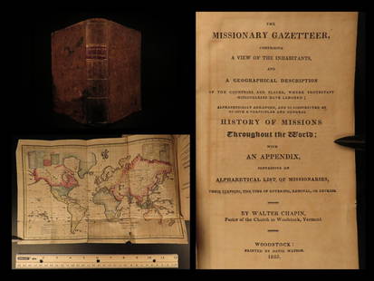
Sold20211825 1ed Missionary Gazetteer Chapin Slavery Indians1825 1ed Missionary Gazetteer Chapin Slavery Indians Illustrated Color World MAP ‘Missionary Gazetteer’ is a general history of missions throughout the world arranged alphabetically with an appendSee Sold Price
Sold20211794 A New and General Map of the Middle DominionsBy: Lewis Evans published by Laurie & Whittle Date: 1794 (Published) London Dimensions: 18.75 x 25.6 inches (47.6 x 65.02 cm) This is a fine old color example of the Laurie & Whittle edition of LewisSee Sold Price
Sold2021Barlow 1807 Antique Map. World HemispheresCopper Engraved Map Published 1807 by Brightly & Kinnersley, Bungay, England for "A General View of the World, Geographical, Historical and Philosophical" by The Rev. E. Blomfield. Engraved by Barlow.See Sold Price
Sold2023Brookes & Baker 1797 Antique Map. World HemispheresCopper Engraved Map Published 1797, London for "The General Gazetteer; Or, Compendious Geographical Dictionary" by Richard Brookes. Engraved by B. Baker. Original outline hand colour. Folds as issued.See Sold Price
Sold2021Lochhead (Pub) 1811 Rare Map. World HemisphereCopper Engraved Map Published 1811 by William Lochhead, Berwick for "Modern Geography: And a Compendious General Gazetteer" Rare. Folds as issued. Paper Size: 17 x 11 inch (43 x 28cm) Some creasing. VSee Sold Price
Sold2022World War 1. Eastern Front, 1914. Army Concentration Areas 1959 old mapTITLE/CONTENT OF MAP: 'Eastern Front, 1914 - Army Concentration Areas // General Map - Eastern Front' DATE PRINTED: 1959 IMAGE SIZE: Approx 25.0 x 33.0cm, 9.75 x 13 inches (Large) TYPE: Antique colourSee Sold Price
Sold2023Brookes, Richard 1791 Antique Map. World HemispheresCopper Engraved Map Published 1791, London for "The General Gazetteer; Or, Compendious Geographical Dictionary" by Richard Brookes. Folds as issued. Paper Size: 12 x 8 inch (31 x 21cm) A few small marSee Sold Price
Sold2024Laurie & Whittle - Map of the Island and Kingdom of SicilyThis exceptional map is from the very handsome atlas entitled A New and Elegant Imperial Sheet Atlas; Comprehending general and particular maps of every part of the world... The work was published bySee Sold Price
Sold20241816 MAP SOUTHERN PART OF RUSSIA or MUSCOVY in EUROPE copper engraving ANTIQUEAntique engraved map of Southern part of Russia from A General Atlas, Being A Collection Of Maps Of The World And Quarters, Their Principal Empires, Kingdoms, &c. Containing Fifty Eight Maps And ChartSee Sold Price
Sold2017Colton: Antique Map of the World, 1861Title/Content of Map: World by Colton Date Printed: 1861 Cartographer: J.H. Colton Material/Medium: Paper Size: 25" x 17 1/3" Hand colored steel engraved. From Colton's 'General Atlas'. Published in NSee Sold Price
Sold2018Mitchell: County Map of PennsylvaniaReserve Reduced! The beautifully detailed and colored county map of Pennsylvania from the 1870 edition of Mitchell's popular New General Atlas of the world. The map is framed by the vine motif borderSee Sold Price
Sold2019Mitchell: 1870s Map of Georgia and AlabamaReserve Reduced! The beautifully detailed and colored county map of the states of Georgia and Alabama from the 1870 edition of Mitchell's popular New General Atlas of the world. The map is framed by tSee Sold Price
Sold2021MITCHELL - New General Atlas [35 American maps] 1867MITCHELL, S. Augustus, Jr.. Mitchell's New General Atlas, containing maps of various countries of the world, plans of cities, etc., ... together with valuable statistical tables. Philadelphia: S. AuguSee Sold Price
Sold2018Pair Antique 19th Century Atlases, Bound MapsPair Antique 19th Century Atlases. ‘Mitchell’s New General Atlas Containing Maps of Various Countries of the World, Plans of Cities, Etc.’ published by S. Augustus Mitchell, Jr. c 1860. ‘AtlasSee Sold Price
Sold2018Pair Antique 19th Century Atlases, Bound MapsPair Antique 19th Century Atlases. ‘Mitchell’s New General Atlas Containing Maps of Various Countries of the World, Plans of Cities, Etc.’ published by S. Augustus Mitchell, Jr. c 1860. ‘AtlasSee Sold Price
Sold2016Hindoostan, India, Nepal, Pakistan, Ceylon, 1839Original engraving from "New General Atlas, being a Collection of Maps of the World & Various Quarters" published by Allan Bell & Co., in London, 1839. Dimensions: 14.25 x 20 inches.See Sold Price
Sold2022An 1882 Black's General Atlas of the WorldAn 1882 Black's General Atlas of the World; including maps of countries in the world, and the states in United state of America, all edge gold, 2.1"x18.2"x13.7"See Sold Price
3 days LeftTrillium Antique Prints & Rare BooksCarey, pub. 1814 - Map of Hindostan or India$50(1 bid)
3 days LeftTrillium Antique Prints & Rare BooksCarey, pub. 1814 - Map of the East Indies with India, China, & New Holland (Australia)$50(1 bid)
3 days LeftTrillium Antique Prints & Rare BooksCarey, pub. 1814 - Map of New South Wales, Australia$50
1818 AuctioneersWORLD STAMPS IN 7 ALBUMS PLUS TUB OF PACKETS ETC Box with 7 world stamp collections, mix of one£30
1818 AuctioneersTUB OF WORLD STAMPS, INCLUDING COVERS, GB PRES PACKS, ROYALTY OMNIBUS ETC. Plastic tub and£42


![MITCHELL - New General Atlas [35 American maps] 1867: MITCHELL, S. Augustus, Jr.. Mitchell's New General Atlas, containing maps of various countries of the world, plans of cities, etc., ... together with valuable statistical tables. Philadelphia: S. Augu](https://p1.liveauctioneers.com/7533/208644/106251073_1_x.jpg?height=310&quality=70&version=1624641782)


