Sold2022EARLY CHART OF NEWFOUNDLAND & NOVA SCOTIA"A New and Correct Chart of the Coast of Newfoundland, from Cape Raze to Cape Bonavista, With Chebucto Harbour on Nova Scotia, Done from the latest Observations. Sold by W&I Mount & T. Page on Tower HSee Sold Price
Sold20231758 Map Chart of World TradewindsAn Accurate Chart of the World with the New Discoveries....Tradewinds.., by Thomas Kitchin, 1758. Large folding map, measures 17 x 13", Condition issues including creasing and repaired breaks at foldsSee Sold Price
Sold2020Des Barres Map of NY Harbor*** START PRICE IS THE RESERVE *** [America] DES BARRES, Joseph Frederick Wallet (1729-1824). A Chart of New York Harbour with the Soundings Views of Land Marks and Nautical directions for the Use ofSee Sold Price
Sold2024A New and Correct Sea-Chart of the Western and Southern Ocean, 18thCEdmund Halley, London, 18th century. Lower right: This CHART is Sold by J. Mount, T. Page, and W. Mount, on Tower-hill. With splits and losses. Overall size appx. 24" x 29".See Sold Price
Sold2018NORTH SEA coast chart. East Anglia Holland Flanders.TITLE/CONTENT OF MAP: 'A correct chart of the sea coasts of England, Flanders and Holland. Shewing the sands, shoals, rocks and dangers, the bays, harbours, roads, buoys, beacons & seamarks on the saiSee Sold Price
Sold2022Map of West Indies from Mercator 1773"A new general chart for the West Indies of E Wright's projection on Mercator's chart," London: J. Mount & T. Page, ca. 1773. From "The English Pilot. The Fourth Book describing the WesSee Sold Price
Sold2020Map of West Indies from Mercator 1773"A new general chart for the West Indies of E Wright's projection on Mercator's chart," London: J. Mount & T. Page, ca. 1773. From "The English Pilot. The Fourth Book describing the West India NavigatSee Sold Price
Sold2017Pearson: Antique Chart of Matanzas Bay, Cuba, 1767Map: A New and Correct Draught of the Bay of Matanzas on ye North side of ye Island Cuba done from a Survey by Robt. Perason Cartographer: Pearson Place & Date: London / 1767 Size: 12" x 9" Condition:See Sold Price
Sold2022N Am.18th C Map W & I Mount & T. PageNorth American Map. Hand Colored map "A Chart of the Sea Coast of New Foundland, New Scotland, New England, New York, New Jersey with Virginia and Maryland" by W & I Mount & T. Page on Tower Hill LondSee Sold Price
Sold2017Six 18th and Early 19th Century Nautical Mapsall shrink-wrapped behind mats, titled as follows: Harbour on the Coast of Chili (1770); Port of Permambuco (1816); Chart of New Zealand (1817); Chart of the Intertropical & West Coasts of AustraliaSee Sold Price
Sold2017US Canada Atlantic & Great Lakes Ports Sea Chart, 1914Title/Content of Map: 'American Atlantic Ports - North Sheet; Inset Chicaco; Boston Harbour; Soo Canals; New York Horbour; Ontario; The Coast from New York to Boston; Buffalo; Montreal; Halifax; NewfoSee Sold Price
Sold2017FRAMED WORLD MAP BY HERMAN MOLL, 1719'A New & Correct Map of the Whole World, by Herman Moll, Geographer, 1719.' Hand tinted and framed. Frame size: 73 x 124 cm (28 3/4 x 48 3/4 in.)See Sold Price
Sold2017Moll - Correct Map of the Whole World, 1719Herman Moll (1654?-1732), cartographer and publisher A New & Correct Map of the Whole World Shewing y.e Situation of its Principal Parts. Viz the Oceans, Kingdoms, Rivers, Capes, Ports, Mountains, WooSee Sold Price
Sold2019Herman Moll 1654-1732), "A New And Correct Map of theHerman Moll 1654-1732), "A New And Correct Map of the World," 1710, hand colored, H. - 22 in., W. - 38 in.See Sold Price
Sold2024POWNALL, Thomas (1777-1805). A New and Correct Map of North America, with the West India Islands,POWNALL, Thomas (1777-1805). A New and Correct Map of North America, with the West India Islands, Divided according to the last Treaty of Peace, Concluded at Paris, 10th Feby. 1763, wherein are particSee Sold Price
Sold2023Laurie & Whittle Map of the British Colonies of North AmericaLAURIE, Robert (1755-1836), and WHITTLE, James (1757-1818). A New and Correct Map of the British Colonies in North America comprehending Eastern Canada...with the adjacent states of New England. EngraSee Sold Price
Sold2023Cartography14. Cartography.A New and Correct Map of the World According to the Latest Discoveries. Double-page engraved map. 17 x 26-1/2 inches, outlined in color; a few stains, hole at upper right corner, generSee Sold Price
Sold2022Large lot of 1960s Nautical Chart Maps New York Harbor, Harlem River, Hudson River, Raritan RiverLarge lot of 1960s Nautical Chart Maps New York Harbor, Harlem River, Hudson River, Raritan RiverSee Sold Price
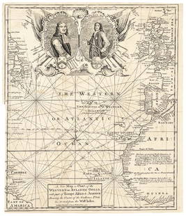
Sold20171740 Ornate Copperplate Engraved Portrait MapHistoric Maps 1740 Ornate Copperplate Engraved Map with Portraits of British Admirals “Robert Blake” & “Edward Vernon, Esq.” 1740-Dated, Copperplate Engraved Map titled “A New Map or Chart oSee Sold Price
Sold2021Des Barres New England Harbor Charts (2)Ipswich Bay. Plan of Newport. 2 harbor sea chart maps. Offset lithographs after the originals from Joseph F.W. Des Barres, Atlantic Neptune . Barre Publishers, 1966-1971. Curtis Paper Mill rag paper,See Sold Price
Sold2023AMERICAN REVOLUTIONARY WAR MAP OF BOSTON, MASSACHUSETTSAMERICAN REVOLUTIONARY WAR MAP OF BOSTON, MASSACHUSETTS, uncolored engraving on paper, A New and Correct Plan of the Town of Boston and Provincial Camp, engraved by Robert Aitken (AmeriSee Sold Price
Sold2021Ɵ CARY, JOHN. NEW AND CORRECT ENGLISH ATLAS. 1825Ɵ CARY, John. New and Correct English Atlas. single volume, engraved title and 47 maps, coloured in outline, modern half calf over original boards, 4to, 1825. (Qty. 1).See Sold Price
Sold20161666 Original Hand Colored Map of Virginiaapprox 21" X 17"...... Pas Caerte van Nieu Nederlandt en de Engelsche Virginies, van Cabo Cod tot Cabo Canrick. (Chart of New Netherland and the English Virginias from Cape Cod to Cape Canrick [i.e. HSee Sold Price
Sold2016Caribbean Island Map, by Mount & Page, 1720 (rare &Spectacular sea chart of the Spanish Main to Puerto Rico, from Mount & Page's English Pilot, Fourth Book. Known as the most important English Atlas of Sea Chart covering the Mediterranean and North AmSee Sold Price
Jun 29JM Hobby Supply and Railroad Artifact AuctionsKanawha and Michigan RY Dressel Switch Lamp$100(1 bid)
13 hrs LeftJasper521837. Mount Desert Rock Light, Maine, after T Doughty (American, 1793 – 1856)$40
4 days LeftTrillium Antique Prints & Rare BooksPrevost - Chart of the Gulf of Mexico (with Florida & Lousiana)$50(1 bid)
Featured19 hrs LeftJasper52Johnson's New Military Map of the United States Showing the Forts, Military Posts &C. With Enlarged$65
1 day LeftThomaston Place Auction GalleriesCOLLECTION OF TRAVEL EPHEMERA, BROCHURES, BOOKLETS, MAPS 1900-1950$100
Jun 23Schilb Antiquarian Rare Books1848 Emory Military Reconnaissance 1ed California MAP Indians Texas New Mexico$2(2 bids)
5 days LeftSanta Cruz Auction Company"Old Slave Market" Albumen Photograph of St. Augustine, Florida 1870s$100
2 days LeftSloans & KenyonA BEAUTIFUL ENGROSSED MAP OF SUMMER PLAY LAND: THE NEW YORK, NEW HAVEN AND HARTFORD RAILROAD JOHN$1,000
May 31Freeman's | Hindman[NATIVE AMERICANS]. Boudoir photograph of "Agent Vandever and a squad of Navajos, July 4, 1889, New$250
May 31Freeman's | Hindman[SHERMAN, William Tecumseh (1820-1891)]. Signed CDV of Sherman as major general, seated at a desk.$400(1 bid)
May 31Freeman's | Hindman[CIVIL WAR - WESTERN THEATER]. A group of 20 CDVs of Union generals and officers, incl. Sherman,$300
Jun 29JM Hobby Supply and Railroad Artifact AuctionsChicago and Alton RR Handlan Caboose Marker Lamp$100(1 bid)


![Des Barres Map of NY Harbor: *** START PRICE IS THE RESERVE *** [America] DES BARRES, Joseph Frederick Wallet (1729-1824). A Chart of New York Harbour with the Soundings Views of Land Marks and Nautical directions for the Use of](https://p1.liveauctioneers.com/1968/163248/82424572_1_x.jpg?height=310&quality=70&version=1583340284)


![[MAP]. SPEED, John. A New Mappe of the Romane Empire. 1676. (1 of 2)](https://p1.liveauctioneers.com/197/329395/177650541_1_x.jpg?height=282&quality=70&version=1715364962)


![[NATIVE AMERICANS]. Boudoir photograph of "Agent Vandever and a squad of Navajos, July 4, 1889, New (1 of 2)](https://p1.liveauctioneers.com/197/329785/177758595_1_x.jpg?height=282&quality=70&version=1715625218)

![[SHERMAN, William Tecumseh (1820-1891)]. Signed CDV of Sherman as major general, seated at a desk. (1 of 2)](https://p1.liveauctioneers.com/197/329785/177758266_1_x.jpg?height=282&quality=70&version=1715625218)
![[CIVIL WAR - WESTERN THEATER]. A group of 20 CDVs of Union generals and officers, incl. Sherman, (1 of 4)](https://p1.liveauctioneers.com/197/329785/177758292_1_x.jpg?height=282&quality=70&version=1715625218)
