Sold2017Adam & Charles Black: Map of Canada, New Brunswick 1854Map of Canada, New Brunswick &c. Adam and Charles Black 1854, 17.25 x 12.5 inches Please note that this lot has a confidential reserve. When you leave a bid in advance of the auction, submit your maxiSee Sold Price
Sold2022Canada, New Brunswick. 1846 by A and C BlackCanada / New Brunswick. 1846. From ‘Black’s General Atlas’, by Adam and Charles Black. Engraved by Sidney Hall. Edinburg. 12 x 17”. Excellent condition. Authenticity GuaranteedSee Sold Price
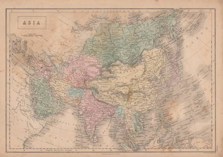
Sold2017Adam & Charles Black: Map of Asia, 1854Map of Asia. Adam and Charles Black 1854, 17.25 x 12.5 inches Please note that this lot has a confidential reserve. When you leave a bid in advance of the auction, submit your maximum. Jasper52 will bSee Sold Price
Sold2017The Solar System, Theory of the Seaons Map, 1854The Solar System, Theory of the Seaons Map. Adam and Charles Black, 1854, 18 x 13 inches No Reserve: This lot starts at $1 and has no reserve as a courtesy so that collectors can determine the true maSee Sold Price
Sold2017Sweden & Norway MapSweden & Norway Map. Adam and Charles Black, 1854, 13 x 18 inches No Reserve: This lot starts at $1 and has no reserve as a courtesy so that collectors can determine the true market value on this authSee Sold Price
Sold2020USA 1903 Lot of 6 State Maps. California, Utah, NevadaPlus Washington, Colorada and Arizona/New Mexico. Lithograph Maps Published 1903 by Adam & Charles Black, Edinburgh & London for "Encyclopaedia Brittannica" Tenth Edition. Centre fold as published. PaSee Sold Price
Sold2020USA 1903 Lot of 8 State Maps of New York & East CoastIncl Maine, Vermont/New Hampshire, Mass., Connecticut/Rhode Island, New York South, New York North, New York West and New Jersey. Lithograph Maps Published 1903 by Adam & Charles Black, Edinburgh & LoSee Sold Price
Sold2017Map of Canada, Eastern Section, Nova Scotia, 1885Map of Canada, Eastern Section. New Brunswick, Nova Scotia. A. & C. Black's Atlas. 1885. 18 x 23 inches No Reserve: This lot starts at $1 and has no reserve as a courtesy so that collectors can determSee Sold Price
Sold2017Map of Turkey in Asia, 1854Map of Turkey in Asia. Adam and Charles Black, 1854, 18 x 13 inches No Reserve: This lot starts at $1 and has no reserve as a courtesy so that collectors can determine the true market value on this auSee Sold Price
Sold2020Canada 1903 Lot of 5 MapsLithograph Maps Published 1903 by Adam & Charles Black, Edinburgh & London for "Encyclopaedia Brittannica" Tenth Edition. Centre fold as published. Paper Size: 16 x 11.5 inch (41 x 29cm) Good ConditioSee Sold Price
Sold2020New Map of That Portion of North America 1854New Map of That Portion of North America Exhibiting the United States and Territories, the Canadas, New Brunswick, Nova Scotia and Mexico also Central America and the West India Islands, 1854, Jacob MSee Sold Price
Sold2022World.- Atlases.- Black (Adam and Charles) Black'sWorld.- Atlases.- Black (Adam and Charles) Black's General Atlas of The World, New and Revised Edition, frontispiece with flags of nations, title, and complete with 52 maps on 55 sheets (numbered 2-56See Sold Price
Sold2017Colton: Antique Map of New Brunswick, Nova Scotia, 1861Title/Content of Map: Canada, New Brunswick, Nova Scotia and Newfoundland Date Printed: 1861 Cartographer: J.H. Colton Material/Medium: Paper Size: 17 1/4" x 13" Hand colored steel engraved Map from 'See Sold Price
Sold2018Tallis/Rapkin: Antique Map East Canada & New BrunswickTitle/Content of Map: 'East Canada and New Brunswick' The map shows the southern part of Quebec and New Brunswick, in districts/counties. Vignettes: North American Indians; Quebec City Date Printed: 1See Sold Price
Sold2017Tallis/ Rapkin: Antique Map East Canada, New BrunswickTitle/Content of Map: 'East Canada and New Brunswick' The map shows the southern part of Quebec and New Brunswick, in districts/counties. Vignettes: North American Indians; Quebec Date Printed: 1851 ISee Sold Price
Sold2021Tallis, John (Pub) 1852 Map East Canada & New BrunswickSteel Engraved Map with Original Outline Hand Color Published 1852-56 by John Tallis, London for "The Universal Pronouncing Dictionary" by Thomas Wright. Drawn & Engraved by John Rapkin. Centre fold aSee Sold Price
Sold2023Map of Canada’s New Brunswick, Nova Scotia, Newfoundland by ColtonTitle: Map of Canada’s New Brunswick, Nova Scotia, Newfoundland by ColtonDate/Period: 1859Materials: Hand colored steering engravedSize: 17 1/2 x 14 1/2”Newfoundland, New Brunswick, Nova ScotiSee Sold Price
Sold2017Cram: Map of Canada New Brunswick & Nova Scotia, 1891Map: Dominion of Canada verso New Brunswick & Nova Scotia Date: 1891 From Cram's "Unrivaled Family Atlas of the World Indexed" TWO Maps, one on each side Size: 14.5 x 11 inches Please note that this lSee Sold Price
Sold2022Kay, John A Series of Original Portraits and Caricature EtchingsKay, John A Series of Original Portraits and Caricature Etchings Edinburgh: Adam & Charles Black, 1877. 'New edition', 2 volumes, 4to, original red quarter morocco, 362 etched plates, tissue guards, bSee Sold Price
Sold2019Lower Canada, New Brunswick, Nova Scotia' Quebec &TITLE/CONTENT OF MAP: 'Lower Canada, New Brunswick, Nova Scotia &c.; Inset map of Newfoundland' DATE PRINTED: 1862 IMAGE SIZE: Approx 31.0 x 45.0cm, 12.25 x 17.75 inches (Large) TYPE: Antique map withSee Sold Price
Sold20201831 Teesdale Map of Canada -- Canada, New BrunswickTitle: 1831 Teesdale Map of Canada -- Canada, New Brunswick and Nova Scotia Date: 1831, London Cartographer: H Teesdale Size: 13.2 X 16.1 in. Additional Information: This is a very nice map of easternSee Sold Price
Sold20211831 Teesdale Map of Canada -- Canada, New BrunswickTitle: 1831 Teesdale Map of Canada -- Canada, New Brunswick and Nova Scotia Cartographer: H Teesdale Year / Place: 1831, London Map Dimension (in.): 13.2 X 16.1 in. This is a very nice map of easternSee Sold Price
Sold20191855 Colton Map of Eastern Canada -- New Brunswick,Title/Content of Map: 1855 Colton Map of Eastern Canada -- New Brunswick, Nova Scotia, Newfoundland, and Prince Edward Id. Date: 1855, New York Cartographer: J Colton Size: 11.8 X 15.2 in. This is a vSee Sold Price
Sold2017John Rapkin Map Of East Canada & New Brunswick, 1851Map: East Canada and New Brunswick Cartographer: John Rapkin Illustrator: H. Warren Publisher: John Tallis & Company Published: London and New York, 1851 Size: 10 x 13 inches Extremely clean, authentiSee Sold Price
6 days LeftHunt and Peck Estate Services, Inc.1794 Laurie & Whittle after Thomas Jefferys Map Of The United States Of America$340(1 bid)
6 days LeftHunt and Peck Estate Services, Inc.Jacques Nicolas Bellin Map Of Western Part Of New France Or Canada$200(1 bid)
May 16Eldred'sCHARLES PAUL GRUPPE (Massachusetts/New York/The Netherlands/Canada, 1860-1940), Bust portrait of a$125
1 day LeftTrillium Antique Prints & Rare BooksMitchell's A New Universal Atlas.. - Volume with 73 Maps$1,000(1 bid)
1 day LeftKunst & Design AuktionshausCharles & Ray Eames, Vitra, 4 Chairs, model Time Life Lobby Chair€4,000
1 day LeftBucklinHeinecken, Robert [SIGNED]; ROBERT HEINECKEN [Friends of Photography Monograph - LIMITED EDITION$50


![Heinecken, Robert [SIGNED]; ROBERT HEINECKEN [Friends of Photography Monograph - LIMITED EDITION (1 of 8)](https://p1.liveauctioneers.com/8658/325945/175540057_1_x.jpg?height=282&quality=70&version=1712964944)


