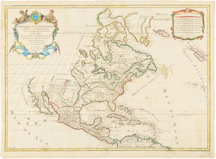
Sold2019Amerique Septentrionale. Antique map of North America.TITLE/CONTENT OF MAP: 'Amerique Septentrionale [North America]' The top image on the right hand side shows the entire map. To view a close up of the map showing the level of printed detail, please cliSee Sold Price
Sold2021AN ANTIQUE MAP OF NORTH AMERICA, "AmériqueAN ANTIQUE MAP OF NORTH AMERICA, "Amérique Septentrionale," PARIS, 1840-1849, hand-colored lithograph on paper, from Atlas Universel Illustré (Nouveau Content), Victor Levasseur (1795-1862), cartogrSee Sold Price
Sold2021AN ANTIQUE MAP OF NORTH AMERICA, "AmériqueAN ANTIQUE MAP OF NORTH AMERICA, "Amérique Septentrionale," PARIS, CIRCA 1809, hand-colored lithograph on paper, Pierre M. Lapie, cartographer, Ambroise Tardieu (1788-1841), publisher and engraver, GSee Sold Price
Sold2017Jaillot: Antique Map of North America, 1696Map: 1696 Jaillot Map of North America (California as an Island) -- Amerique Septentrionale Divisee en ses Principales Parties Date Printed: 1696 Amsterdam Cartographer: H. Jaillot Size: 19.3 x 23 in.See Sold Price
Sold2017de Vaugondy: Antique Map of North America in 1783Map: Amerique Septentrionale Dressee sur les Relations les Plus Modernes des Voyageurs et Navigateurs, ou se Remarquent les Etats Unis Cartographer: Robert de Vaugondy Place & Date: Paris / 1750/1783See Sold Price
Sold2017de la Tour: Antique Map of North America, 1779Map: L'Amerique Septentrionale ou se Remarquent les Etats Unis Cartographer: Brion de la Tour Place & Date: Paris / 1779/1783 Size: 28 5/8" x 19 7/8" Condition: full wash color; cleaned and sized; minSee Sold Price
Sold2017Dufour: Antique Map of North America, 1836Title/Content of Map: 'Amérique Septentrionale' The map shows the Mexican-US border as it was prior to the Mexican-American War, with Mexican Territory including much of the present day US state of CSee Sold Price
Sold2017de la Tour: Antique Map of Wartime North America, 1777Title/Content of Map: 'L'Amérique Septentrionale' The map was published during the American War of Independence, predating the Louisiana Purchase. Louisiana territory west of the Mississippi appearsSee Sold Price
Sold2022Antique French map of North America by N. LorrainAntique French map of North America (Amerique Septentrionale' by N. Lorrain. Marked on bottom Longitude Occidentale de Paris. Early 20th century. 22 3/4"h x 25 1/4"wSee Sold Price
Sold2023[ANTIQUE MAP] PARTIE DU NORD DE L'AMERIQUE SEPTENTRIONALE. C.1770s[ANTIQUE MAP] PARTIE DU NORD DE L'AMERIQUE SEPTENTRIONALE. Pour Servir a L'historie Philisophique et Politique... By Rigobert Bonne (1727-1795) Map of the eastern part of North America shows the BritiSee Sold Price
Sold20231755 Robert De Vaugondy Map of North America Large1755 Robert De Vaugondy Map of America. Mid-Atlantic, New York, New Jersey, Pennsylvania Virginia, Maryland, New England, Carolina and Ohio. Partie De L'Amerique Septentrionale. Map in matte is aboutSee Sold Price
Sold2020L'amerique Septentrionale 1706 Map North AmericaL'amerique Septentrionale 1706 Map Of North America (french). 24 X 20 Inches, Framed.See Sold Price
Sold2018* ANVILLE, Jean Baptiste Bourguignon d' (1697-1782).* ANVILLE, Jean Baptiste Bourguignon d' (1697-1782). Amérique Septentrionale. Paris, 1746. Engraved map of North America, hand-colored in outline, on 4 sheets joined as 2, overall image 900 x 1730 mmSee Sold Price
Sold20241782 Janvier/Lattre French Map of North America1782 Janvier/Lattre, L'Amerique Septentrionale Divisee en ses Principaux map of North America including the present day United States, Canada, Mexico, Central America, the Caribbean, Cuba, Florida, thSee Sold Price
Sold20231842 Thierry Map of North America -- Amerique SeptentrionaleTitle: 1842 Thierry Map of North America -- Amerique Septentrionale Cartographer: Thierry Year / Place: 1842 Map Dimension (in.): 8.2 X 10.6 in. This is a lovely map of North America. Independent TexaSee Sold Price
Sold20191792 Elwe Map of North America -- AmeriqueTitle/Content of Map: 1792 Elwe Map of North America -- Amerique Septentrionale Divisee en Ses Principales Parties Cartographer: J ElweDate: 1792, Amsterdam Size: 18.3 X 23.1 in. This is an outstandinSee Sold Price
Sold2021ROBERT DE VAUGONDY (France, 1688-1766), Map of NorthROBERT DE VAUGONDYFrance, 1688-1766Map of North America "Amerique Septentrionale, dressee, sur les Relations les plus Modernes des Voyaeurs et Navigateurs". Hand-colored engraving, 18.5"See Sold Price
Sold2017Monin: Map of North America, 1833Map: 1833 Monin Map of North America -- Amerique Septentrionale dressee par N. Lorraine Pere, attache au Depot Gal. de la Guerre. Cartographer: C Monin Year / Place: 1833, Paris Map Dimensions: 10 x 1See Sold Price
Sold2021MAP, North America, LevasseurNorth America. Victor Levasseur, Amerique Septentrionale, from Atlas Universel Illustre, 1835 (circa). Hand Color. This early version of Levasseur's decorative map of North America shows Mexico in conSee Sold Price
Sold2023V. Levasseur Hand Tinted Map Of North AmericaV. Levasseur Hand Tinted Map Of North America. Marked: "Amerique Septentrionale , Geographie et Statistique de V. Levasseur Ingenteur Geographe, Grave par Laguillermie, rue St. Jacques, No.82, IllustrSee Sold Price
Sold2017Levasseur: Antique Map of North America, 1840Title/Content of Map: 1840 Levasseur Map of North America - Amerique Septrentionale Date Printed: 1840 Paris Cartographer: V. Levasseur Size: 11 x 16.5 in. Condition: Excellent. Minor age toning; issuSee Sold Price
Sold2016Hubert Jaillot. Amerique Septentrionale diviséeHubert Jaillot. Amerique Septentrionale divisée en ses principales parties<See Sold Price
Sold2015Map of North America 1719Heading: (North America) Author: Sanson, Nicolas/ Hubert Jaillot Title: Amerique Septentrionale divisée en ses Principales Parties, ou sont distingués les uns des autres les Estats suivant quils appSee Sold Price
Sold2022Three Maps of North America, One World MapFour maps, including: Robert Wilkinson, The United States of America Confirmed By Treaty 1783, London, circa 1800-1812, engraving on wove paper; L'Amerique Septentrionale, "Terres vues par Tchirikov 1See Sold Price
May 17Albion AuctionsClarke & Russell 1814 Hand Col Map. Canada - British Dominions in North America$5(1 bid)
4 days LeftJasper52Antilles, Golfe du Mexique & Amérique Centrale. Caribbean. MALTE-BRUN c1871 map$35
May 18THOS. CORNELL GALLERIES, LTD.GROUP OF ANTIQUE AND VINTAGE MAPS, INC.. NORTH AND SOUTH AMERICA, WORLD MAPS, LOSSES THROUGHOUT,$100(1 bid)


![Amerique Septentrionale. Antique map of North America.: TITLE/CONTENT OF MAP: 'Amerique Septentrionale [North America]' The top image on the right hand side shows the entire map. To view a close up of the map showing the level of printed detail, please cli](https://p1.liveauctioneers.com/5584/147595/74587297_1_x.jpg?height=310&quality=70&version=1565730371)


![[ANTIQUE MAP] PARTIE DU NORD DE L'AMERIQUE SEPTENTRIONALE. C.1770s: [ANTIQUE MAP] PARTIE DU NORD DE L'AMERIQUE SEPTENTRIONALE. Pour Servir a L'historie Philisophique et Politique... By Rigobert Bonne (1727-1795) Map of the eastern part of North America shows the Briti](https://p1.liveauctioneers.com/8321/286473/155024526_1_x.jpg?height=310&quality=70&version=1686787412)