Sold2018ANTIQUE HAND COLORED WORLD MAP WITH SCENIC CORNERS.ANTIQUE HAND COLORED WORLD MAP WITH SCENIC CORNERS ON EARLY LAID PAPER. IMAGE 22 3/4 X 19 1/4See Sold Price
Sold2018Zurner: Antique Map of the World, 1700Title/Content of Map: World Map by Zurner Date Printed: c1700 Cartographer: A.F. Zurner Material/Medium: Paper Size: 20" x 21" Rare world Map. Hand colored engraved. Please note that this lot has a coSee Sold Price
Sold2017Russell: Antique Map of World, 1804Map: 1804 Russell Map of World -- The World Cartographer: J. Russell Year / Place: 1804 London Map Dimensions: 4.5 x 6.5 in. Condition: Excellent condition, hand colored continental outlines; slight aSee Sold Price
Sold20241839 Known Ancient World Map by MoninTitle: 1839 Known Ancient World Map by Monin Date/Period: 1839 Materials: Hand colored, engraved Size: 17 1/2 x 12 1/2" This map is a fascinating illustration of the world as known to the ancient GreeSee Sold Price
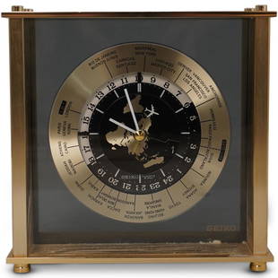
Sold2020Seiko World Desk ClockDESCRIPTION: A Seiko desk clock. Features a world map dial with white colored hands and airplane motif seconds hand. Marked "Seiko, Quartz Japan" Finished with time zone markers and a gilt brass case.See Sold Price
Sold2021Antique Map Lithographs New York City, World MapPair Antique Hand Colored Map Lithographs of New York City, and a World Map. Unframed 18 inches x 23 inchesSee Sold Price
Sold2023Antique Map Print - Map of World - Scheme of Oceanic and Continental BasinsDescription: This vibrant hand-colored map of the world was published in Chicago by Rand McNally in the last quarter of the 19th century for inclusion in the company’s geography textbook, McNallSee Sold Price
Sold2021Antique Italian MapAntique hand-colored map of Tuscany. [Sight: 12" H x 18" W; Frame: 15" H x 25" W]. In good condition.See Sold Price
Sold2018Seutter: Antique Map of the World, 1740Title/Content of Map: World by Seutter Date Printed: c1740 Cartographer: Matthaus Seutter Material/Medium: Paper Size: 24" x 19 1/2" Original hand colored Copperplate engraved. Published in Augsburg iSee Sold Price
Sold2017ANTIQUE MAP OF THE WORLDTwo page, hand colored engraving. Dimensions: Frame H 26.5" x W 28.5", Sight H 18" x W 20.75" Condition: No issues to noteSee Sold Price
Sold2017Mitchell: Antique Map of the World; Mercator ProjectionTitle: Map of the World on the Mercator Projection Maker: Samuel A. Mitchell Date: 1867 Dimensions (inches): 23 x 15 Medium: Hand Colored Lithograph Condition: Great Condition Samuel Augustus MitchellSee Sold Price
Sold2017Colton: Antique Map of the World, 1861Title/Content of Map: World by Colton Date Printed: 1861 Cartographer: J.H. Colton Material/Medium: Paper Size: 25" x 17 1/3" Hand colored steel engraved. From Colton's 'General Atlas'. Published in NSee Sold Price
Sold2017Mitchell: Antique Map of Illinois, 1869Title/Content of Map: Illinois by Mitchell Date Printed: 1869 Cartographer: Augustus S. Mitchell Material/Medium: Paper Size: 15" x 12" Hand colored engraved Map. From 'Mitchell's New General Atlas.'See Sold Price
Sold2017Mitchell: Antique Map of the World, 1840Title: Map of the World Maker: Samuel A. Mitchell Date: 1840 Dimensions (inches): 9.5 x 12 Medium: Hand Colored Engraving Good Condition Samuel Augustus Mitchell (1790-1860) was an American geographerSee Sold Price
Sold2018Johnson: Antique Map of the World, 1868Title/Content of Map: World by Johnson Date Printed: 1868 Cartographer: A.J. Johnson Material/Medium: Paper Size: 23 1/2" x 18" Hand colored engraved Map. From Johnson's 'New Illustrated Family AtlasSee Sold Price
Sold2017Johnson: Antique Map of Globular World, 1868Title/Content of Map: Globular World Date Printed: 1868 Cartographer: A.J. Johnson Material/Medium: Paper Size: 18" x 23 3/4" Hand colored engraved Map. From Johnson's Illustrated Family Atlas of theSee Sold Price
Sold2017Mitchell: Antique Map of St. Louis, 1869Title/Content of Map: St. Louis Date Printed: 1869 Cartographer: Augustus S. Mitchell Material/Medium: Paper Size: 15" x 12" Hand colored engraved Map. From 'Mitchell's New General Atlas.' Published iSee Sold Price
Sold2018Mitchell: Antique Map of Pacific Ocean Islands, 1869Title/Content of Map: Pacific Ocean Islands with Australia Date Printed: 1869 Cartographer: Augustus S. Mitchell Material/Medium: Paper Size: 15 1/3" x 12" Hand colored engraved Map. Published in PhilSee Sold Price
Sold2017Mitchell: Antique Map of Northwest US, 1869Title/Content of Map: Oregon, Washington, Idaho & Montana by Mitchell Date Printed: 1869 Cartographer: Augustus S. Mitchell Material/Medium: Paper Size: 15" x 12" Hand colored engraved Map. From 'MitcSee Sold Price
Sold2017Mitchell & Cowperthwait: Antique Map of the World, 1854Title: Map of the World on the Glubular Projection Makers: Samuel A. Mitchell and Thomas Cowperthwait Date: 1854 Dimensions (inches): 17 x 13 Medium: Hand Colored Lithograph Good Condition with smallSee Sold Price
Sold2017Hardesty: Antique Map Nebraska Dakota Montana WyomingScarce 1875 Hardesty map of Nebraska, Dakota, Montana & Wyoming. From the scarce Jones and Hamilton Illustrated Historical Atlas of the World Illustrated. Large format hand-colored map shows TerritorySee Sold Price
Sold2022Antique Map Print - Map of Bohemia - Map of Czech Republic - KingdomAntique outline hand colored map from edition of Meyer’s world atlas, edited by Ludwig Ravenstein, published by Bibliographic Institute in 1872. Technique: Engraving. Place: Leipzig, Germany. SSee Sold Price
Sold2022Original Antique Map -Pommern Provinz - Map of Bornholm Island Baltic SeaAntique outline hand colored map from edition of Meyer’s world atlas, edited by Ludwig Ravenstein, published by Bibliographic Institute in 1872. Technique: Engraving. Place: Leipzig, Germany. SSee Sold Price
Sold2022Original Antique Map - Mecklenburg-Schwerin - Map of Northern GermanyAntique outline hand colored map from edition of Meyer’s world atlas, edited by Ludwig Ravenstein, published by Bibliographic Institute in 1872. Technique: Engraving. Place: Leipzig, Germany. SSee Sold Price
4 days LeftTrillium Antique Prints & Rare BooksBraun & Hogenberg, pub. 1575 - View of Bologna, Italy$100(1 bid)
4 days LeftTrillium Antique Prints & Rare BooksBraun & Hogenberg, pub. 1575 - View of Basel, Switzerland$100
4 days LeftTrillium Antique Prints & Rare BooksBraun & Hogenberg, pub. 1575 - View of Limbourg, Belgium$100
4 days LeftTrillium Antique Prints & Rare BooksBraun & Hogenberg, pub. 1575 - Coats of arms of Hannonia, Hennegau in Belgium$100
4 days LeftTrillium Antique Prints & Rare BooksBraun & Hogenberg, pub. 1575 - View of Marseille, France$100
4 days LeftTrillium Antique Prints & Rare BooksBraun & Hogenberg, pub. 1575 - View of Haarlem, Netherlands$100


![Antique Italian Map: Antique hand-colored map of Tuscany. [Sight: 12" H x 18" W; Frame: 15" H x 25" W]. In good condition.](https://p1.liveauctioneers.com/1221/202668/104343461_1_x.jpg?height=310&quality=70&version=1622581573)


