Sold2023THE SHETLAND ISLANDS antique map by GW BACON Scotland 1885 oldTITLE/CONTENT OF MAP: 'The Shetland Islands' DATE PRINTED: 1885 IMAGE SIZE: Approx 33.0 x 24.0cm, 13 x 9.5 inches (Large); Please note that this is a folding map. TYPE: Colour Antique Lithograph Map CSee Sold Price
Sold2023S AMERICA NW. Colombia Ecuador Peru Bolivia Venezuela Amazonos. Lima 1893 mapTitle: S AMERICA NW. Colombia Ecuador Peru Bolivia Venezuela Amazonos. Lima 1893 map Description: South America N.W; Inset map of Lima' by GW Bacon (1893). Antique colour map, 26.0 x 17.5cm, 10.25 x 7See Sold Price
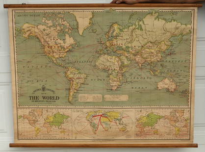
Sold2015Bacon's Excelsior Map of The WorldOn Mercator's Projection, printed in London by G. W. Bacon & Co., Ltd., circa 1880. Chromolithograph laid on canvas with both original wood hangers. 39 1/2" x 30".See Sold Price
Sold2023SOUTH AMERICA NE. Brazil. Inset Rio de Janeiro; Trinidad. BACON 1893 old mapTitle: SOUTH AMERICA NE. Brazil. Inset Rio de Janeiro; Trinidad. BACON 1893 old map Description: South America; Inset maps of Environs of Rio de Janeiro; Trinidad' by GW Bacon (1893). Antique colour mSee Sold Price
Sold2023EDINBURGH Travel Advertising Poster. Graphic Map with 3D renderings of Buildings. Printed in G.B.EDINBURGH Travel Advertising Poster. Graphic Map with 3D renderings of Buildings. Printed in G.B. Dimensions: H: 40 inches: W: 25 inches: D: 7 inches --- US Shipping charge: $35 for the first poster.See Sold Price
Sold20231702 Antient & Present State of the Empire of Germany antique w/ MAP in ENGLISHThe Antient and Present State of the Empire of Germany... London, 1702 With 1 map and a frontispiece copper engraving. Original leather binding, covers are reinforced inside of the endpapers Very goodSee Sold Price
Sold2022Kitchin, MAP OF NORTH AMERICA, 1787MAP OF NORTH AMERICA DRAWN FROM THE LATEST AND BEST AUTHORITIES, drawn by Thomas Kitchin, engraved by G. Terry, published by Jonathan Harrison, London, 1787. Copperplate engraving with handcoloring deSee Sold Price
Sold2022Antique Map Print - Map of Ireland - Europe - Alexander Keith JohnstonMap of Ireland by Keith Johnston, F.R.S.E. Engraved & printed by W. & A.K. Johnston, Edinburgh. William Blackwood & Sons, Edinburgh & London, (1861). Technique: Engraving. Date: 1861. Artist: AlexandeSee Sold Price
Sold2024Antique Map - Views on the coast of Asia. J. Webber del. Engraved after J. Webber and W. Bligh.Views on the coast of Asia. J. Webber del. (Engraved after J. Webber and W. Bligh. London, G. Nicol and T. Cadell, 1785). Author: Webber, John, 1751-1793; Bligh, William, 1754-1817; Cook, James, 1728-See Sold Price
Sold2019'A New General Map of America' Dated 1747Antique map of America in copper plate engraving by Emanuel Bowen dated 1747, London. COA from Marlborough Antiques on verso. Has been hand colored, framed in burl wood. Measures 20.25"H x 23.25"W fraSee Sold Price
Sold2023England and Europe, (6) antique vols.England and Europe, (6) antique vols., Includes: [Thomas Pennant] Some Account of London. Printed for Robt. Faulder, 1791, 2nd ed., with fold-out map and 2 fold-out engravings, 9.75"h x 8.25"w; with,See Sold Price
Sold2017Map LotLot (2) maps including Ireland (G.W. Bacon & Co. sight 8 1/2" x 12"), and "BAVARIA-HESSE/US ZONE/WURTEMBERG BADEN" (sight 23" x 20").See Sold Price
Sold20172 Antique English Etchings London Map & Hen w Chix2 Antique English Etchings, one is a B.R. Davies drawn London Map from 1843 & one is a Hen with Chicks, from a series by Fores, painted by J.F. Herring. Hen measures 25 x 27 inches. Both nicely framedSee Sold Price
Sold2022London.- Bacon (George W.) Bacon's New Map of LondonLondon.- Bacon (George W.) Bacon's New Map of London divided into half mile squares and circles, lithograph with some hand-colouring, sheet 680 x 990 mm (26 3/4 x 39 in), mounted on linen, folding intSee Sold Price
Sold2022G. W. Bacon GlobeG. W. Bacon Globe Having imported globe from London mapmakers upon a Weber Costello style copper finished cast iron table top base including (3) clawed feet and classical motif globe having '12-Inch GSee Sold Price
Sold2017Colton: Antique Map of Mississippi, 1871Title/Content of Map: Colton's Mississippi Date Printed: 1871 Cartographer: G. W. Colton Material/Medium: Paper Size: 13" x 17" Hand colored lithograph. From 'Colton's American Atlas.' Published in NeSee Sold Price
Sold2017Colton: Antique Map of Wisconsin, 1871Title/Content of Map: Wisconsin by Colton Date Printed: 1871 Cartographer: G. W. Colton Material/Medium: Paper Size: 17" x 14" Hand colored lithograph. From 'Colton's American Atlas.' Published in NewSee Sold Price
Sold2017Colton: Antique Map of Ohio, 1871Title/Content of Map: Ohio by Colton Date Printed: 1871 Cartographer: G. W. Colton Material/Medium: Paper Size: 17" x 14" Hand colored lithograph. From 'Colton's American Atlas.' Published in New YorkSee Sold Price
Sold2017Colton: Antique Map of Minnesota, 1871Title/Content of Map: Minnesota by Colton Date Printed: 1871 Cartographer: G. W. Colton Material/Medium: Paper Size: 15" x 17" Hand colored lithograph. From 'Colton's American Atlas.' Published in NewSee Sold Price
Sold2021Antique Engraving - New York City & HarborCharles Mottram (1807-1876) engraving of New York Harbor after J.W. Hill, published 1855 by F. and G.W. Smith. Circa 1855. Marked "Proof" in lower left margin. Printed by McQueen. [Image: 33" H x 53"See Sold Price
Sold2022Slatter & Rose's Motoring and Cycling Road Map. OxfordTitle: Slatter & Rose's Motoring and Cycling Road Map. Oxford District. Cartographer: Bartholomew, John & Co. Publisher: G.W. Bacon & Co., LTD. Height: 24 Width: 34 Extremely early road map intended fSee Sold Price
Sold20211892 Egypt MapAuthor: Bacon Title: 1892 Egypt Map Medium: Ink on Paper Dimenions: 13.5"X21" Description: Map of Egypt dated 1892. Part of Bacon's Commercial and Library Atlas of the World. Published by G.W. Bacon iSee Sold Price
Sold20211892 Map of Euro-AsiaTitle: 1892 Map of Euro-Asia Medium: Ink on Paper Dimensions: 19"X13.5" Description: Map of Europe and Asia dated 1892. Part of Bacon's Commercial and Library Atlas of the World. Published by G.W. BacSee Sold Price
Sold2017Colton: Antique Map of Philadelphia, 1871Title/Content of Map: Philadelphia by Colton Date Printed: 1871 Cartographer: G.W. Colton Material/Medium: Paper Size: 14 1/2" x 17 1/4" Hand colored lithograph. Published in New York. From 'Colton'sASee Sold Price
7 days LeftTrillium Antique Prints & Rare BooksAlbin - Pair of Bird Engravings: Goosander & Sheldrake$40
3 days LeftJasper521816 VOYAGE TO ABYSSINIA by HENRY SALT w/ MAP antique 1st AMERICAN EDITION rare$400
May 05Tremont AuctionsCollection of 13 antique silver mounted cowrie shell boxes. 1) Birmingham mark on inside rim and$1,200(1 bid)


![England and Europe, (6) antique vols.: England and Europe, (6) antique vols., Includes: [Thomas Pennant] Some Account of London. Printed for Robt. Faulder, 1791, 2nd ed., with fold-out map and 2 fold-out engravings, 9.75"h x 8.25"w; with,](https://p1.liveauctioneers.com/188/277488/146207485_1_x.jpg?height=310&quality=70&version=1675532530)


