Sold2019Map of LouisianaAntique Map of Louisiana, "Carte de la Louisiane et Pays Voisins, Paris, 1757", by Bellin, 8 3/4 in. x 12 in., framedSee Sold Price
Sold2021Bayou Teche, Louisiana MapAntique Bayou Teche, Louisiana Map , 1890, specifically, a survey of a portion of La Petite Fausse Pointe, that is the subject of a legal dispute between W.R. Archer and Adrien Gonsoulin, 39 in. x 25See Sold Price
Sold2021US Coast Survey Map of the Louisiana CoastAntique US Coast Survey Map of the Louisiana Coast , "U.S. Coast Survey, A.D. Bache, Superintendent", 1855, lithograph, with later hand-coloring, showing Vermillion Bay, LA to Mobile Bay, AL, sight 15See Sold Price
Sold2021Eight Antique Maps by HoefnagelEight Antique Maps by Hoefnagel , 17th c., from Civitates Orbis Terrarum, 5 hand-colored, sheets 16 in. x 20 in Provenance: Property deaccessioned from the Louisiana State Museum, proceeds to be usedSee Sold Price
Sold2024Antique Map of New OrleansAntique Map of New Orleans, "Plan of New Orleans the Capital of Louisiana", 1761, by Benning, engraved map from the London Magazine, 7 1/2 in. x 9 1/2 in., framed.See Sold Price
Sold2023Antique Map of New OrleansAntique Map of New Orleans, "Plan of New Orleans The Capital of Louisiana; with the Disposition of its Quarters and Canals as they have been traced by Mr. de la Tour in the Year 1720", later reproductSee Sold Price
2017Thomson: Antique Map of the United States, 1817United States of America' The map shows the United States including the first 17 states to acceed, including Tennessee, which had joined in 1796. Ohio, Louisiana and Indiana, which had all joined theSee Sold Price
Sold2024Arrowsmith & Lewis - Map of LouisianaThis engraved map is from Aaron Arrowsmith & Samuel Lewis's A New and Elegant General Atlas. Comprising all the new discoveries, to the present time... The work was published in Boston in 1812 by ThomSee Sold Price
Sold202118th Century Florida Louisiana Coast Map - JefferysCarte de la Floride occidentale et Louisiane. La peninsule et golfe de la Floride ou canal de Bahama avec les isles de Bahama. Contributors - Le Rouge, Georges-Louis, Jefferys, Thomas, -1777. PrintedSee Sold Price
Sold2021Antique Coast Survey Map of the Atchafalaya BayAntique Coast Survey Map of the Atchafalaya Bay , "Preliminary Chart of Atchafalaya Bay Louisiana... A.D. Bache, Superintendant", 1858, lithograph, with later hand-coloring, sight 24 1/2 in. x 31 1/4See Sold Price
Sold2021Four Antique MapsFour antique maps. Including a very early hand made paper map of Florida and Virginia. Fragment of old newspaper on back dated 1630. Unframed, each approx H 21" W 24". All in excellent condition, minoSee Sold Price
Sold2023TWO ANTIQUE MAPS OF CHINA.Two antique maps of China, including Chinae by Abraham Ortelius, 1595, image 14.25” x 18.25”, with map of Eastern Asia, Le table de la region orientale, image 10” x 13.5”.See Sold Price
Sold2018Morden: Antique Map of Florida & the Great Lakes, 16931693 map of Florida and the Great Lakes by Robert Morden. 5 x 5 inches. A very special map--one of the very earliest obtainable English maps of the American colonies. A Map of Florida and Ye Great LakSee Sold Price
Sold2021Eleven Antique Maps of EuropeEleven Antique Maps of Europe , 16th-18th c., incl. Ptolemy from 1541 (4); a Blaeu map of "Regno di Napoli", Hondius map of the Holy Land, de Wit map of Southern Spain, an undated manuscript map of MeSee Sold Price
Sold20161760 French + Indian War Map Louisiana + FloridaHistoric Maps French & Indian War Era Map of Louisiana & Florida c. 1760 French & Indian War Era, Historic Map Titled, “Carte de la Louisiane, et de la Floride. Par M. Bonne, Ingenieur-Hydrographe dSee Sold Price
Sold2022John SPEED: Two Antique Maps of IrelandTwo framed antique maps of Ireland by John Speed, a well known English cartographers circa 17th century. [Maps: 15" H x 20" W; Frames: 24" H x 28 1/2" W].See Sold Price
Sold2023Six Antique Maps of America Engravings, 19th c., H.- 7 1/4 in., W.- 4 1/2 in., Framed- H.- 15 in.,Six Antique Maps of America Engravings, 19th c., includes: "Map 8 1776 / Framing Declaration," "Map 5 1692 / New France: Map of the Discoveries of Marquette, La Salle and Other Frenchmen," "Map No. 12See Sold Price
Sold2020AN ANTIQUE MAP, "America," MILAN, CIRCA 1832,AN ANTIQUE MAP, "America," MILAN, CIRCA 1832, hand-colored lithograph on paper, titled "America," above "Dono," and the encyclopedic title, attributed as one of seven folding maps found in the thirtSee Sold Price
Sold20244 Antique Maps of Various LocationsFrench Map of Canada By Guillaume Del'Isle, Map Of Asia By Guiljelmo Blaeuw, Double Hemisphere map By Nicolao Visscher, Map Of The Holy Land Jerusalem, all maps are roughly 18" x 14"See Sold Price
Sold2018Three Antique Mapswith The Countries and Islands Of The South Sea Company, 25 3/4" x 19 3/4" (sight) America Meridio Nalis, 15" x 20" (sight) Hispaniae, Novae Sivae, 14 1/2" x 20" (sight)See Sold Price
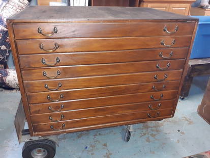
Sold2020Antique Map Architect Blue Print Sea Captain Chest 9 drAntique Map Architect Blue Print Sea Captain Chest 9 drawers custom made flat file cabinet for sea captain architect or blue prints,Maps, 9 drawers all on roller glides drawers work great very good coSee Sold Price
Sold2022[ANTIQUE MAPS] DE VAUGONDY - MAPPE MONDE 1804[ANTIQUE MAPS] dE VAUGONDY, ROBERT. "MAPPE MONDE dressée suivant les nouvelles relations et assujettie aux observations astronomiques" 1804, 72X44cm. Hand-coloured. Frame not included. Map will beSee Sold Price
Sold2022Four Antique Maps of the United States: Thomas & Andrews, Boston, "A Map of the United States ofFour Antique Maps of the United States: Thomas & Andrews, Boston, "A Map of the United States of America," A. Doolittle, N. Haven; Joh. George Schreibern, "America" printed in LeipSee Sold Price
Sold2018Four Small Antique Maps Pertaining to Cyprusas follows: Hogenberg, F. and Braun G. Famaugusta, copperplate engraving (Cologne, late 16th century) sheet, 8.75 x 14 in., giving a birds-eye view of the Cypriot port city; Mercator, Hondius, JanssonSee Sold Price
2 days LeftTrillium Antique Prints & Rare BooksKohler & Weigel - Map of Louisiana Territory or Eastern United States (extends from New Mexico to$120(4 bids)
Jun 15Trillium Antique Prints & Rare BooksWilson - Louisiana Tanager, Lewis's Woodpecker, & Clark's Crow. 20$75
Jul 06Case Antiques, Inc. Auctions & Appraisals5 TVA Map Books incl. Tennessee & New York c. 1935-1950$250
Featured6 days LeftJasper52World in hemispheres. Mountains & rivers. SWANSTON 1860 old antique map chart$260
6 days LeftJasper52Andreas Parish, Ayre Sheading, Isle of Man by James Woods 1829 old antique map$260
Featured6 days LeftJasper52Plan of Cardona, during 1714 siege. Catalonia. BASIRE c1747 old antique map$320
6 days LeftJasper52Isola di Malta, Gozo, Comino e Cominotto. DE ROSSI 1686 old antique map chart$1,200
563 Lots AwayAkiba GalleriesAntique Mast, Crowell, & Kirkpatrick Map Of Texas, California, & Nevada$25(1 bid)
22 hrs LeftHolabird Western Americana CollectionsMeteorological Chart of the Earth c1845 (2) [180794]$100


![John SPEED: Two Antique Maps of Ireland: Two framed antique maps of Ireland by John Speed, a well known English cartographers circa 17th century. [Maps: 15" H x 20" W; Frames: 24" H x 28 1/2" W].](https://p1.liveauctioneers.com/1221/264089/138965458_1_x.jpg?height=310&quality=70&version=1667576821)


![[ANTIQUE MAPS] DE VAUGONDY - MAPPE MONDE 1804: [ANTIQUE MAPS] dE VAUGONDY, ROBERT. "MAPPE MONDE dressée suivant les nouvelles relations et assujettie aux observations astronomiques" 1804, 72X44cm. Hand-coloured. Frame not included. Map will be](https://p1.liveauctioneers.com/8321/253807/131946557_1_x.jpg?height=310&quality=70&version=1657219401)


![Meteorological Chart of the Earth c1845 (2) [180794] (1 of 3)](https://p1.liveauctioneers.com/2699/331495/178785749_1_x.jpg?height=282&quality=70&version=1717094933)