Sold2019Antique Map of Part of Virginia, c. 1939Description: Antique map on heavy stock paper depicting the Virginia towns of Jamestown, Williamsburg and Yorktown by Robert Ball. Map details feature subtle hand tinting highlighted with red. Circa 1See Sold Price
Sold2021Colton Railroad and County Map United States 1878Colton, after G. W., Colton's Railroad and County Map of the United States, The Canadas, &c, 1878, antique map on paper, folded as originally issued, 33 x 42 inches, in a wood frame 36.5 x 47.5 inchesSee Sold Price
Sold202419TH C. GRAPHITE ON PAPER COUNTRY TOWN LANDSCAPE DATED 186819TH C. FRAMED GRAPHITE ON PAPER - COUNTRY TOWN / LANDSCAPE "SIGNED" GCR AND DATED 1868 - MEASURES APPROX. 24 1/2" WIDE X 17 1/2" HIGHSee Sold Price
Sold202318th C Antique Historical Map Of Montreal Quebec1758 Antique Historical Hand Tinted Map Of Montreal, Titled Plan of the Town and Fortifications of Montreal or Ville Marie in Canada. Map measures 7 inches H x 10 W within matting, framed 14.5 inchesSee Sold Price
Sold2021Antique 18th C Map, England, Johann Baptist HomannOriginal decorative copperplate engraving on hand-laid paper with strike impression, map of England and Wales in full wash color, cartouche with title, two coats of arms and vignette, titled "Magnae BSee Sold Price
Sold2023Antique 18th C Map of the Gulf of Mexico, M. Rizzi ZannoniM. RizziZannoniMapofthe Gulfof Mexico, Caribbean, and parts of Central America, hand-colored engraving on paper, titled "Carte Geo-Hydrographique du Golfe de Mexico Et Des Ses Isles". Published in ParSee Sold Price
Sold2023Map: Antique Town of Center Moriches, Suffolk County, LONG ISLAND NYDescription: Map: Antique Town of Center Moriches, Suffolk County, LONG ISLAND NYMeasurement approximate: Frame 38 x 27 InchesMaterial: PaperSee Sold Price
Sold2022Pair hand-colored antique maps, 17th c.Pair hand-colored antique maps, 17th c., Philipp Cluver (German, 1580-1622), "Viro Antiqua domo Generoso ac Nobili: Omni Virtute pollenti...", engraving of Ancient Italy on laid paper, as two sheets jSee Sold Price
Sold202417TH C. ANTIQUE MAP SIEGE OF LA ROCHELLE, FRANCE, FRAMED"Seige et Reddition de La Rochelle, Octobre 1628", handcolored engraving on wove paper, Claes Jansz. Visscher (II), (workshop of), Germany, 1627 - 1629. In gilt molded frame, matted under UV non-glareSee Sold Price
Sold20241859 Clark & Hopkins Wall Map Litchfield County CTAntique 1859 Clark & Hopkins Topographical Wall Map of Litchfield County Connecticut, Coated Fabric Backed Paper with Original Rollers. Measures 55 inches x 51 inches. Please note condition issues notSee Sold Price
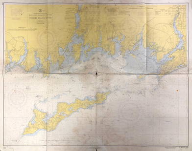
Sold2020Land Ho! Antique Fishers Island Sound, RI-CT-NY USCGDescription: Ahoy! Antique Coast Guard nautical chart of Fishers Island Sound, RI-CT-NY. Numbered C. & G. S. 358; published 1968. Material: paper. Measurement: approximate 36" x 45" (INCHES). ShippingSee Sold Price
Sold2024Antique German Kampen Town Color Copper EtchingA colored copper map etching on paper with borders. Titled, "Icon Civitatis Campensis, Cuius Situs, Isulam Fluvium, Eleganti Venustate, Decorat," produced circa 1580 as part of "Civitates Orbis TerrarSee Sold Price
Sold2024Barclay, James 1808 Antique Map. India, Ceylon & Maldives"Hindoostan with the Islands of Ceylon, Maldivas &c &c." Copper Engraved Map Published 1806, London for "Barclay's Complete and Universal English Dictionary" by the Rev. James Barclay. Paper Size: 10See Sold Price
Sold2022Kelly, Christopher 1836 Antique Map. South Africa"Colony of Good Hope &c" Copper Engraved Map Published 1836, London for "A New and Complete System of Universal Geography" by Christopher Kelly. Maps Engraved by Findlay, Wallis and others. Paper SizeSee Sold Price
Sold2021Pair 18th C French Maps after the AntiqueTo include "A View of the Town-House or Guild Hall of Paris" and "Vue de Chateau Royal D'amboise" : mid 20th century prints after the antique, housed in concave giltwood frames. Copperplate engravingsSee Sold Price
Sold2018Original Harper's Southern States Civil War Map, C 1863Antique original Harper's Southern States Civil War Map, Ca.1863. On Top reads, “Map Of The Southern States, including rail roads, country towns, state capital, country roads, the southern coast froSee Sold Price
Sold2018Original Harper's Southern States Civil War Map, C 1863Antique original Harper's Southern States Civil War Map, Ca.1863. On Top reads, “Map Of The Southern States, including rail roads, country towns, state capital, country roads, the southern coast froSee Sold Price
Sold20232 Maps of Delaware by Finley of Philadelphia & Lucasc.1824 Delaware Map by Anthony Finley, from A New General Atlas. Hand Colored with details of the county seats, roads, towns and settlements, and watershed. I The Cypress Swamp is well drawn along theSee Sold Price
Sold2015Small Russian Silver CupDESCRIPTION:Small silver cup engraved with a town landscape and floral designs. Marked on bottom: C.O. 1895, 84, HE3" CIRCA: Late 19th Ct. (1895) ORIGIN: Russia DIMENSIONS:H:2" Diameter: 1.5"See Sold Price
Sold20174 19th c. KY & TN Maps1st item: "Kentucky and Tennessee" Map, by Sidney E. Morse and Samuel Breese, published by Harper and Brothers, 1845. Colored cerograph of Kentucky and Tennessee depicting towns, roads, county lines,See Sold Price
Sold2023Reproduction of an Antique Map Atchison County KansasReproduction of an Antique Map Atchison County Kansas MEDIUM: Reproduce-printed on Paper DIMENSIONS: Sight 14 x 17 inches CIRCA: Originally drawn up in 1876/reproduced late 20th C. ATTRIBUTION: L.H. ESee Sold Price
Sold2020Netherlands 1747 Antique Map. Bergen-Op-Zoom"A New and Exact Plan of the Town and Fortifications of Bergen-Op-Zoom" Copper Engraved Map Published 1732-85, London for "The London Magazine" Folds as issued. Paper Size: 10.5 x 8 inch (27 x 20cm) GSee Sold Price
Sold2019Land Ho! Antique Western L.I. Sound, CT U.S. CoastDescription: Ahoy! Antique Coast Guard nautical chart of the L.I. Sound. Numbered C. & G. S. 1213; printed in 1968. Material: paper. Measurement: approximate 34" x 40" (INCHES). Shipping cost: $10; diSee Sold Price
Sold2021Scarce 1853 Texas map by Roswell SmithAntique and hard to find antebellum map with full original hand coloring. Engraving on paper. Shows forts, rivers, locations of tribes, towns, counties and topographical features. Eastern Indian TerriSee Sold Price
3 days LeftAlbion AuctionsMarmocchi, F. C. 1845 Hand Col Map. Judaica - Jewish World & Israelites Camp$5
3 days LeftAlbion AuctionsMarmocchi, F. C. 1845 Hand Col Map. Holy Land. Persia Empire, Alexander the Great$5
3 days LeftAlbion AuctionsMarmocchi, F. C. 1845 Hand Col Map. Black Sea. Greece Armenia Turkey Russia$5
3 days LeftAlbion AuctionsPrichard & Walker 1844 Hand Colored Map. Ethnological Map of Asia$15(2 bids)
12 hrs LeftJasper521894 Johnston Map of Oceania [verso] Island in the Indian Ocean and Near Africa -- Oceania [verso]$40
12 hrs LeftJasper521647 Jansson Map Central Netherlands -- Ducatus Gelriae pars quarta quae est Arnhemiensis siue$95
12 hrs LeftJasper521760 Kitchin Map of the German Romantic Road Area -- A Map of the Circle of Franconia from the$45
May 22Kotler Galleries & AuctioneersRICHARD HAYLEY LEVER CONCARNEAU FRANCE DRAWING C. 1908 - AFFILIATION: American, (1876 - 1958) -$1,200
12 hrs LeftJasper521890s Cram Map of Vermont [verso] New Hampshire -- Vermont [verso] New Hampshire$30
Featured12 hrs LeftJasper52Mitchell’s Map of Asia showing travel routes London, India, China & Japan, 1860$45


![1894 Johnston Map of Oceania [verso] Island in the Indian Ocean and Near Africa -- Oceania [verso] (1 of 2)](https://p1.liveauctioneers.com/5584/328338/176911535_1_x.jpg?height=282&quality=70&version=1715113718)


![1890s Cram Map of Vermont [verso] New Hampshire -- Vermont [verso] New Hampshire (1 of 2)](https://p1.liveauctioneers.com/5584/328338/176911596_1_x.jpg?height=282&quality=70&version=1715113718)
