Sold2018Original Harper's Southern States Civil War Map, C 1863Antique original Harper's Southern States Civil War Map, Ca.1863. On Top reads, “Map Of The Southern States, including rail roads, country towns, state capital, country roads, the southern coast froSee Sold Price
Sold2018Original Harper's Southern States Civil War Map, C 1863Antique original Harper's Southern States Civil War Map, Ca.1863. On Top reads, “Map Of The Southern States, including rail roads, country towns, state capital, country roads, the southern coast froSee Sold Price
Sold20201861 Civil War military map in full hand-colorLarge format, double-page “Johnson’s New Military Map of the United States showing the Forts, Military Posts &c. with Enlarged Plans of Southern Harbors” by Johnson and Ward. Original and vividSee Sold Price
Sold2017Wells: Antique Civil War Era Map of Gulf of Mexico 1863Title/Content of Map: Parts of the Southern States Bordering on Gulf of Mexico constructed and engraved to illustrate the war with the South Date Printed: 1863 Cartographer: Wells and Smith Size (inchSee Sold Price
Sold2020Map of the Civil War, 1863Heading: (Civil War) Author: Perrine, Charles O. and Capt. John S. Bishop Title: Perrine's New Topographical War Map of the Southern States with a Chronology of the Great Rebellion [with] A Concise HiSee Sold Price
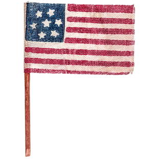
Sold20217Star Confederate States Gauze Cloth Parade FlagFlags c. 1863 Civil War Era Confederate 7-Star Parade Flag c. 1863 Civil War, Antique 7-Star Confederate Secession "Support" Parade Flag, 2.5" x 1.75", Printed Gauze Fabric Construction with originalSee Sold Price
Sold20217-Star Confederate States Gauze Cloth Parade FlagFlags c. 1863 Civil War Era Confederate Parade Flag with Pole c. 1863 Civil War, Antique 7-Star Confederate "Support" Parade Flag, 2.5" x 1.75", Printed Gauze Fabric Construction with Its original 6"See Sold Price
Sold20231863 Civil War map of Mississippi RiverOriginal and authentic 1863 “Map of Mississippi, Showing the Field Operations of Generals Sherman, Grant and Banks.” Published at the beginning of 1863 in Harper’s Weekly. Small piece missinSee Sold Price
Sold2023Original 1863 Civil War Map - MAP OF THAT PART OF TENNESSEE THROUGH WHICH GENERAL ROSECRANS ADVANCEDOriginal 1863 Civil War Map - MAP OF THAT PART OF TENNESSEE THROUGH WHICH GENERAL ROSECRANS ADVANCED FROM MURFREESBORO TO TULLAHOMA AND CHATTANOOGA, Harper's Weekly, September 5, 1863. Approx. Size: 1See Sold Price
Sold2022Fine example of Johnson & Ward map of New York, 1863Beautiful map of New York state from Johnson and Ward’s New Illustrated Steel Plate Family Atlas. This scarce map gives a fascinating look at the state during the Civil War. Excellent originalSee Sold Price
Sold201619thc Civil War Map, Invasion of PennsylvaniaOriginal 19th Century Map, Page from "Harper's Pictorial History Of The Civil War." Shows Pennsylvania, Maryland ,Virginia & Delaware. Gettysburg, Philadelphia & Washington. June, 1863. Approx 10" X 1See Sold Price
Sold20171862 Johnson Civil War Military Map of US1862 Johnson Civil War Military Map of US -- Johnson's New Military Map of the United States Showing the Forts, Military Posts &c. all the Military Divisions with Enlarged Plans of Southern Harbors…See Sold Price
Sold2015Map of the Southern States by Pictorial of the CivilOriginal engraving titled “Map of The Southern States" with vignettes in the corners of Scott, McClellan, Lincoln, and Seward and titled on lower margin "Prepared for Harper's Pictorial History of tSee Sold Price
Sold2016[Civil War; Map] History of the War [1864]Bishop, John S., Capt.: A CONCISE HISTORY OF THE WAR. DESIGNED TO ACCOMPANY PERRINE'S NEW WAR MAP OF THE SOUTHERN STATES.... Indianapolis. [1864]. 132, xi, [1] pp. plus large folding map. 5.75" x 3.75See Sold Price
Sold2022JOHN TALLIS (1817-1876) AN AMERICAN CIVIL WAR MAP, "United States," LONDON, CIRCA 1863,JOHN TALLIS (1817-1876) AN AMERICAN CIVIL WAR MAP, "United States," LONDON, CIRCA 1863, hand-colored lithograph on wove paper showing, "Federal, Non Slave Holding States (Red); Border, Slaveholding (BSee Sold Price
Sold2016Large 1862 US Civil War Wall MapColton's Map of the Southern States. Including Maryland, Delaware, Virginia, Kentucky, Tennessee, Missouri, North Carolina, South Carolina, Georgia, Alabama, Mississippi, Arkansas, Louisiana, Texas ..See Sold Price
Sold2021Map of the Southern States - American Civil WarTitle: Map of the Southern States, Including Rail Roads, County Towns, State Capitals, County Roads, the Southern Coast from Delaware to Texas, Showing the Harbors, Inlets, Forts and Position of BlocSee Sold Price
Sold2021Civil War era map of deep southern states, 1860/62Title: Civil War era map of deep southern states, 1860/62 Description: "Authentic vintage map of three deep south states whose partial borders are defined by the mighty Mississippi River, one of the gSee Sold Price
Sold2019United States. Civil war era military map. ShowingTitle/Content of Map: United States. Civil war era military map. Showing southern ports Date: 1863 Cartographer: By Johnson & Ward. From, Johnson’s New Illustrated Family Atlas Size: 18x 26 1/4”.See Sold Price
Sold2016CONFEDERATE CIVIL WAR GLASS, PEWTER & LEATHER FLASKCONFEDERATE CIVIL WAR GLASS, PEWTER & LEATHER WHISKY FLASK, C1863, H 6", L 4":Confederate States Of America, Civil War, glass whisky flask oval in shape with a silver plate metal screw off cap on theSee Sold Price
Sold20171860s Civil War Original Navy Button Die From ScovilleCivil War 1860s Civil War Original Navy Button Die From Scoville c. 1860 Civil War Period, Original United States Navy Button Steel Die, Not Cancelled or Defaced, from the Scoville Manufacturing CompaSee Sold Price
Sold2023Civil War era 1863 map of Mexico & Caribbean nationsLovely and vintage double-page map showing all of Mexico, Central America, Texas, Indian Territory and states of the Deep South during the middle of the American Civil War. Map has an 1860 copyright bSee Sold Price
Sold2019A group of 4 original Civil War TokensTitle: A group of 4 original Civil War Tokens Provenance: Indian Head dated 1863, Army & Navy dated 1863, Our Army dated 1863, 1861 Henry C. Welles Waterloo, NY Druggist and book seller token. These fSee Sold Price
Sold2021May 1863 Civil War Harpers Weekly NewspaperHistoric Images of the Civil War / Harpers Weekly Re-Issue Newspaper / Extremely Hard to Find the Original / This is a NOT an Original – It is a RE-ISSUE COPY/ Multiple Photos PostedSee Sold Price
5 days LeftWeatherham Estate TreasuresAbraham Lincoln Bronze Bust Sculpture On Marble Base - Signed Original - 10lbs$400
May 14Fleischer's AuctionsLincoln's Funeral Cortège Book by Custodian of Lincoln's Tomb$150(2 bids)
Jun 02Schilb Antiquarian Rare Books1874 Confederate 1ed General Joseph E Johnston Civil War Narrative CSA Military$1
May 15University ArchivesLincoln Brady Photo Study for Carpenter's "First Reading of the Emancipation Proclamation," Meserve $100(1 bid)
3 days LeftActivity Auctions1866 The War With The South Civil War Abraham Lincoln CSA Union Leather 12" Tall$1,000
Jun 02Schilb Antiquarian Rare Books1866 Women of the Civil War 1ed Americana Gettysburg Military Robert E Lee Moore$1(1 bid)
May 14Fleischer's Auctions[LINCOLN] 1864 California National Union Ticket "Rally Round the Boys!"$100(1 bid)


![Map of the Civil War, 1863: Heading: (Civil War) Author: Perrine, Charles O. and Capt. John S. Bishop Title: Perrine's New Topographical War Map of the Southern States with a Chronology of the Great Rebellion [with] A Concise Hi](https://p1.liveauctioneers.com/642/164280/82938913_1_x.jpg?height=310&quality=70&version=1584491135)


![[Civil War; Map] History of the War [1864]: Bishop, John S., Capt.: A CONCISE HISTORY OF THE WAR. DESIGNED TO ACCOMPANY PERRINE'S NEW WAR MAP OF THE SOUTHERN STATES.... Indianapolis. [1864]. 132, xi, [1] pp. plus large folding map. 5.75" x 3.75](https://p1.liveauctioneers.com/3532/91776/46880401_1_x.jpg?height=310&quality=70&version=1469669287)


![[BUTTRE, J. C. (1821-1893), engraver]. Abraham Lincoln. [Ne... (1 of 1)](https://p1.liveauctioneers.com/928/328184/176813626_1_x.jpg?height=282&quality=70&version=1714496988)


![[LINCOLN] Currier & Ives "Freedom to the Slaves" Lithograph (1 of 1)](https://p1.liveauctioneers.com/7226/322253/173251614_1_x.jpg?height=282&quality=70&version=1710004847)

![[CIVIL WAR] Beardless Lincoln Cover w/ 6th Ohio Cavalry Letter (1 of 3)](https://p1.liveauctioneers.com/7226/322253/173251606_1_x.jpg?height=282&quality=70&version=1710004847)


![[LINCOLN] 1864 California National Union Ticket "Rally Round the Boys!" (1 of 1)](https://p1.liveauctioneers.com/7226/322253/173251604_1_x.jpg?height=282&quality=70&version=1710004847)
![[RE LEE] Signed Photograph & Letter To Namesake (1 of 3)](https://p1.liveauctioneers.com/7226/325455/175169169_1_x.jpg?height=282&quality=70&version=1712370394)


