Sold2020Original Map of Nantucket By E.K. Godfrey, 1882Original Historical Map of Nantucket By E.K. Godfrey, 1882, "New Map of the Streets of Nantucket Mass.", with Location of Public Buildings and Places of Interest, copyright, 1882 By E.K. Godfrey, unfrSee Sold Price
Sold2017First printed plan of New Haven, showing Yale CollegeA plan of the town of New Haven : with all the buildings in 1748...William Lyon (fl. c. 1800-1806). Engraved map. New Haven: T. Kensett, 1806. 28 1/4 x 20 1/2 inches sheet. The Kensett map is the firsSee Sold Price
Sold2021Pierre Jeanneret (1896-1967) Sofa, 'Easy Sofa'Pierre Jeanneret (1896-1967)Sofa, 'Easy Sofa'Teak and fabricModel created circa 1960H 72 × L 153 × P 78 cmProvenance: Public buildings, Chandigarh, India.Bibliography: L. & P. Seguin, Le CorSee Sold Price
Sold2022Rare Pasquale Romanelli Sculpture of Benjamin FranklinRare Pasquale Romanelli Sculpture of Benjamin Franklin and his whistle. Carved marble. A few versions of this sculpture are in public buildings. Statue only 42 inches. Sculpture supported by carved maSee Sold Price
Sold20211825 Plan of Yorktown in Virginia & Adj Country1825 Map, Plan of Yorktown in Virginia and Adjacent Country, Exhibiting the operations of the American French & English armies, during the Siege of that place in Oct. 1781. Sheet is irregularly trimmeSee Sold Price
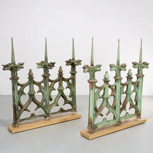
Sold2023Cass Gilbert, Woolworth Building metalworkCass Gilbert, Woolworth Building metalwork, c. 1913, New York, two segments of pressed copper sheet metal with natural verdigris patina, originally surrounding the roof of the Woolworth building, 233See Sold Price
Sold2016America.- Burr (David H.) - An Atlas of the State ofContaining a Map of the State and of the Several Counties, [third edition], engraved title, 51 hand-coloured engraved maps and plans on 52 sheets as issued, including double-page and folding, some foxSee Sold Price
Sold2022(SPANISH AMERICA.) Tomas Lopez. Atlas Geographico de la America Septentrional y Meridional.(SPANISH AMERICA.) Tomas Lopez. Atlas Geographico de la America Septentrional y Meridional. Engraved title, portrait, and 38 engraved maps and plans. 12mo, 5x3½ inches, contemporary mottled calfSee Sold Price
Sold2024[CANADA REPORTS] LOT OF 2 VOLUMES SOLD TOGETHERCANADA REPORTS. A lot of 2 volumes sold together. Both quarto, half leather over cloth boards, worn, with folding maps/plates. Including: PLANS OF VARIOUS LAKES AND RIVERS BETWEEN LAKE HURON AND THE RSee Sold Price
Sold2022[MANUSCRIPT MAP-MAINE] CHADWICK, JOSEPH. Plan of part of the lands belonging to the Heirs of Brigd.r[MANUSCRIPT MAP-MAINE] CHADWICK, JOSEPH. Plan of part of the lands belonging to the Heirs of Brigd.r Waldo ... measured by Joseph Chadwick Nov.r 1765. [New England]: November, 1765. Manuscript surveySee Sold Price
Sold2023Pierre Charles L'Enfant Plan of the City of Washington Map18th century. Appx. 13" x 16" overall. Lightly mounted to acid free board with small margin tears and chips.See Sold Price
Sold2022JOHN MARIN Woolworth Building, No. 2.JOHN MARIN Woolworth Building, No. 2. Etching and drypoint, 1913. 330x265 mm; 13x10½ inches, full margins. Second state (of 2). Edition of approximately only 10. Signed in pencil, lower right. PuSee Sold Price
Sold2022MJOHN MARIN Woolworth Building (The Dance)MJOHN MARIN Woolworth Building (The Dance) Etching and drypoint, 1913. 327x262 mm; 12x10 inches, full margins. Second state (of 2). Artist's proof, aside from the edition of 30. Inscribed "Artist's PrSee Sold Price
Sold2024HARRY S. TRUMAN(1884-1972) 33rd President of the United States who led the country in the closing days of World War II and through the re-building of Europe under the Marshall Plan and the Korean War. Superb signedSee Sold Price
Sold20219 Adirondack Mountain Maps & Pamphlets,1870-90'sCollection 1870s Adirondack Mountain Maps & Pamphlets. Includes the historic Preliminary Survey of the Adirondacks made by Verplanck Colvin in 1893, two "Birch Bark from the Adirondacks" books from 18See Sold Price
Sold2022Christo, Wrapped Reichstag, Project for BerlinChristo Wrapped Reichstag, Project for Berlin 1994collage with pencil, enamel paint, photograph by Wolfgang Volz, crayon, charcoal, map and tape on panel 14 h × 11 w in (36 × 28 cm)See Sold Price
Sold2015A Fine & Rare Map of New York.Bernard Ratzer "Plan of the City of New York". Signed lower right in the plate "T. Kitchin Sculpt" (Kitchin recorded the cartographer's name as Ratzen (sic) rather than Ratzer). The map backed, rolledSee Sold Price
Sold2017William Faden, rare Revolutionary War Map of NYWilliam Faden, rare Revolutionary War Map of NY, William Faden (British, 1749-1836), "A Plan of the Operations of the Kings Army under the Command of General Sr. William Howe, K.B. in New York and EasSee Sold Price
Sold2020Speed's carte-a-figures map of America, California anHeading: Author: Speed, John Title: America, with those known parts in that unknowne worlde both people and manner of buildings Described and inlarged by I.S. Ano. 1626 Place Published: London PublisSee Sold Price
Sold2022(KANSAS TERRITORY.) Otis B. Gunn. Gunn's New Map of Kansas and the Gold Mines(KANSAS TERRITORY.) Otis B. Gunn. Gunn's New Map of Kansas and the Gold Mines Embracing all the Public Surveys up to the 6th Principal Meridian. Compiled from the Original Field Notes by O.B. Gunn. LaSee Sold Price
Sold2022(NEW ORLEANS.) Benjamin Moore Norman. Norman's Plan of New Orleans & Environs.(NEW ORLEANS.) Benjamin Moore Norman. Norman's Plan of New Orleans & Environs. Finely detailed hand-colored engraved pocket map of New Orleans with an 86-point keyed reference panel. 17¾x24½See Sold Price
Sold2022Cadastral map of land in Portola district SF 1869Heading: -1869 Author: Title: Plan of the Haley Purchase, west of and adjoining the Hudson Tract. To be sold by Maurice Dore & Co. April 27th, 1869. Title U.S. Patent, and Bernal Rancho Place PublishSee Sold Price
Sold2022[MANUSCRIPT MAP-FLORIDA & MISSISSIPPI RIVER] Map Showing Raiford's Proposed Artificial River and[MANUSCRIPT MAP-FLORIDA & MISSISSIPPI RIVER] Map Showing Raiford's Proposed Artificial River and Plan to Continue the Western and Southern Inland System of Navigation to Harbors in the Atlantic. [FernSee Sold Price
Sold2017JOHN MARIN ETCHING AND DRYPOINT 1913JOHN MARIN (AMERICAN, 1870-1953), ETCHING AND DRYPOINT, 1913, PLATE SIZE: H 12 3/4", W 10 1/4", "WOOLWORTH BUILDING #2:Pencil signed (within the plate mark); signed, titles and dated in the plate; insSee Sold Price
3 days LeftRR AuctionJohn D. Rockefeller Twice-Signed Map of Cleveland's Superior Road$325(2 bids)
4 days LeftGrace Auction & Estate Gallery LLCPlan de Paris Map 1927 by Ilonka Karasz, Washington Square Bookshop$20
3 days LeftPUBLIC SALESet of 3 Lorentz Kleiser Gouache Paintings, Designs for Rip Van Winkle Tapestry Series$100(3 bids)
3 days LeftPUBLIC SALEPair of Lorentz Kleiser Gouache Paintings, Designs for Washington Irving Tapestry 1923$50
3 days LeftPUBLIC SALESet of 3 Lorentz Kleiser Gouache Paintings, Designs for Italian Tapestry$75(2 bids)
3 days LeftPUBLIC SALECollection of 8 Tapestry Design Gouache Paintings by Lorentz Kleiser$75(2 bids)
3 days LeftPUBLIC SALESet of 3 Lorentz Kleiser Gouache Paintings, Designs for Missouri State House Tapestry$50
3 days LeftPUBLIC SALELorentz Kleiser Gouache Painting, Design for Fort Pitt (Pittsburgh) Tapestry 1933$50(1 bid)
3 days LeftPUBLIC SALECollection of 8 Tapestry Design & Chairs Gouache Paintings by Lorentz Kleiser$50(1 bid)
3 days LeftMatthew Bullock AuctioneersGroup of Department 56 Christmas Village and City Buildings$15(1 bid)
6 days LeftToomey & Co. AuctioneersFrank Lloyd Wright, Wasmuth Portfolio: Buildings, Plans and Designs$50


![America.- Burr (David H.) - An Atlas of the State of: Containing a Map of the State and of the Several Counties, [third edition], engraved title, 51 hand-coloured engraved maps and plans on 52 sheets as issued, including double-page and folding, some fox](https://p1.liveauctioneers.com/410/84263/43496522_1_x.jpg?height=310&quality=70&version=1453293226)

![[CANADA REPORTS] LOT OF 2 VOLUMES SOLD TOGETHER: CANADA REPORTS. A lot of 2 volumes sold together. Both quarto, half leather over cloth boards, worn, with folding maps/plates. Including: PLANS OF VARIOUS LAKES AND RIVERS BETWEEN LAKE HURON AND THE R](https://p1.liveauctioneers.com/8124/343618/186530165_1_x.jpg?height=310&quality=70&version=1726178725)
![[MANUSCRIPT MAP-MAINE] CHADWICK, JOSEPH. Plan of part of the lands belonging to the Heirs of Brigd.r: [MANUSCRIPT MAP-MAINE] CHADWICK, JOSEPH. Plan of part of the lands belonging to the Heirs of Brigd.r Waldo ... measured by Joseph Chadwick Nov.r 1765. [New England]: November, 1765. Manuscript survey](https://p1.liveauctioneers.com/292/250642/130213647_1_x.jpg?height=310&quality=70&version=1654271664)


![[MANUSCRIPT MAP-FLORIDA & MISSISSIPPI RIVER] Map Showing Raiford's Proposed Artificial River and: [MANUSCRIPT MAP-FLORIDA & MISSISSIPPI RIVER] Map Showing Raiford's Proposed Artificial River and Plan to Continue the Western and Southern Inland System of Navigation to Harbors in the Atlantic. [Fern](https://p1.liveauctioneers.com/292/250642/130213644_1_x.jpg?height=310&quality=70&version=1654271664)


