Sold2021Boating Maps, Brock cay to channel cay, bitter guanaMaps from 1981 tropic Isle publishers, Inc, by Harry Kline, Brock Cay to Channel Cay, Bitter Guana Cay to Brock Cay, Bimini Cat Cay. size, 11“ x 17“See Sold Price
Sold2021Boating Maps, west end, green turtle to Hope-town,Maps from 1981 tropic Isle publishers, Inc By Harry Kline, west end Grand Bahama, Green turtle to Hopetown, cistern cay to bitter guana cay. Size 11“ x 17“See Sold Price
Sold2021Boating Maps, sail rocks to cistern cay, spaniel cay,Maps from 1981 tropic Isle publishers, Inc By Harry Kline, sale rocks to cistern Cay, staniel cay, allans cay harbour. Size 11“ x 17“See Sold Price
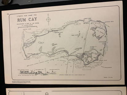
Sold2021Boating maps, rum cay, conception island, San Salvador.Maps from 1981 tropic Isle publishers, Inc By Harry Kline, Rum Cay, Conception island, San Salvador. Size 11“ x 17“See Sold Price
Sold2021Boating maps, the Jumentos Cays end drag at IslandMaps from 1981 tropic Isle publishers, Inc By Harry Kline, The Jumentos Cays in Ragan Island harbour, French wells and turtle sound, crooked Acklins islands. Size 11“ x 17“See Sold Price
Sold2021Boating Maps, central Bahamas, farmers cay galliot cutMaps from 1981 tropic Isle publishers, Inc by Harry Klein, Central Bahamas, farmers Cay galliot cut, size 11“ x 17“See Sold Price
Sold2021Boating Maps, hub of Abaco, man-of-war cay to CherokeeMaps from 1981 tropic Isle publishers, Inc By Harry Kline hub of Abaco, man-of-war cay to. Cherokee sound, marsh Harbour size 11“ x 17“See Sold Price
Sold2021Boating maps, Spanish wells to Harbor Island, cays toMaps from 1981 tropic Isle publishers, Inc By Harry Kline, Spanish wells to Harbor Island, cays to Eleuthera, current cut and current settlement. Size 11“ x 17“See Sold Price
Sold2021Boating maps, Nassau Harbour, New Providence Island,Maps from 1981 tropic Isle publishers, Inc By Harry Kline, Nassau Harbour, new Providence Island, Little Harbor and alder cay anchorages. Size 11“ x 17“See Sold Price
Sold2021Boating Maps, Elizabeth Harbor, Pike Creek, ElizabethMaps from 1981 tropic Isle publishers inc, by Harry Klein, Elizabeth Harbor, pipe Creek, Elizabeth Harbor to hog Cay, size 11“ x 17“See Sold Price
Sold2021Boating maps, The brights of intros, Stafford Creek toMaps from 1981 tropic Isle publishers, Inc By Harry Kline, The brights of andros, Stafford Creek to North bright, jousters cays to Stanford creek. Size 11“ x 17“See Sold Price
Sold2021Boating maps, Powell Point to rock sound, EleutheraMaps from 1981 tropic Isle publishers, Inc By Harry Kline, Powell point to rock sound, Eleuthera island, Spanish wells and ridley head channel. Size 11“ x 17“See Sold Price
Sold2021LeRoy Neiman: Outrigger Canoe Race 1976 Signed LithograLeRoy Neiman: Outrigger Canoe Race Molokai-Oahu Signed and Inscribed in Pencil lower left. Serigraph on cream paper map of Hawaiian Channels Sight 24" x 33", Framed 30" x 39". Also titled, dated, signSee Sold Price
Sold2023TWO MARTHA'S VINEYARD MAPS/CHARTS 19th Century 28.5” x 20.5” and 18.5” x 14”TWO MARTHA'S VINEYARD MAPS/CHARTS19th Century“Muskeget Channel” and “Edgartown Harbor”.28.5” x 20.5” and 18.5” x 14”. Framed 31” x 23” and 2See Sold Price
Sold2016Map, Hudson River, Rev. War, Sauthier, 1776At the top of the map is written: "A Topographical Map of Hudsons River, with the Channels Depth of Water, Rocks, Shoals, &c. and the Country Adjacent, from Sandy-Hook, New York and Bay to Fort EdwardSee Sold Price
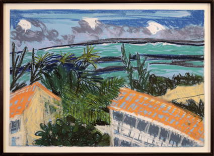
Sold2024Jennifer Bartlett December-January, Parrot Cay, #23 Signed Pastel Prepared Paper 2000-2001 FramedA bright and energetic Neo-Expressionist pastel drawing on prepared paper titled "December-January, Parrot Cay, #23" by Jennifer Barlett. Signed on verso. Created 2000-2001. Original gallery tag fromSee Sold Price
Sold2024JOHN MAYNOR HERON CAY LIGHTHOUSE HIGHWAYMEN GICLEEJohn Maynor (1948-2016) Highwaymen giclee (print on canvas) of Heron Cay Lighthouse in Mount Dora, Florida. Numbered 14 of 30 on verso and dated 1-15-2012. This giclee was from a Highwaymen art show iSee Sold Price
Sold2024A Caribbean Beach Resort Decor Print "Castaway Cay."(Walt Disney World, 1988-2000s) A print titled "Castaway Cay" with a matte signed by artist Stedman, depicting a Disney Cruise ship in port at the private island. This piece was displayed in Disney'sSee Sold Price
Sold2022JEFFERYS, THOMAS The Coast of West Florida and Louisiana/ The Peninsula and Gulf of Florida orJEFFERYS, THOMAS The Coast of West Florida and Louisiana/ The Peninsula and Gulf of Florida or Channel of Bahama with the Bahama Islands. London: Robert Sayer, 20 February 1775. Engraved map on joinedSee Sold Price
Sold2022VIETNAM - Début XXe siècleScène animées Grès Four de Cay May H. 85 cm - L. 44 cm AccidentéSee Sold Price
Sold2022New Omega Speedmaster Grey Side of the Moon 44mm Meteorite Dial on LeatherBezel Color: Gold, GrayDial Pattern: Meteorite Indices: Stick IndexesYear Manufactured: 2020-Now Vintage: NoCase Color: Gray Caseback: ExhibitionDepartment: Men Watch Shape: RoundCase Size: 44 mm CaseSee Sold Price
2022Omega Speedmaster 'Silver Snoopy Award' 50th Anniversary - 310.32.42.50.02.001Model: OMEGA SpeedmasterDepartment: Unisex Adults Case Color: SilverCase Material: Stainless Steel Movement: Mechanical (Manual)Type: Wristwatch Bezel Color: BlueWith Papers: Yes Year Manufactured: 20See Sold Price
2022Omega Moonphase Platinum Chronograph Ref# 304.93.44.52.99.003 44.25mmBrand: OmegaDepartment: Unisex Adult Case Color: SilverCase Size: 44.25mm Type: WristwatchReference Number: 304.93.44.52.99.003 Customized: NoStyle: Sport Model: Omega MoonphaseFeatures: Anti-magneticSee Sold Price
3 days LeftJasper52Bahamas. San Salvador Crooked Rum Cay Mariguana ADMIRALTY chart 1892 (1919) map$140
3 days LeftJasper52Grand Bahama & Great Abaco Islands. Bahamas. ADMIRALTY sea chart 1886 (1968) map$140
2 days LeftJasper521850 View of Rapids of Niagara Falls -- Rapids and Bridge above the Falls of Niagara$30
3 days LeftJasper52Amér Sep Grandes Antilles 73 Jamaica Pedro Bank San Andrés VANDERMAELEN 1827 map$45
3 days LeftJasper52Bahamas harbours Pelican Abaco Berry I Jumentos ADMIRALTY chart 1899 (1920) map$140
May 26Whites Auctions CharlestonWilliam Ker Reid Sterling Silver Footed Salver Monogrammed To Chris Dunphy$170(3 bids)
7 days LeftSchilb Antiquarian Rare Books1844 Harper Library United States Poland Navigation MAPS 14v Voyages RARE LOT$56(5 bids)
7 days LeftSchilb Antiquarian Rare Books1869 ATLAS 42 MAPS America Africa Australia GERMANY Switzerland Sydow RARE$155(4 bids)
4 days LeftRail & Road AuctionsEleven Army Corps of Engineers Port Series No. 1 Through No. 8 Books with Fold Out Maps$35(2 bids)
4 days LeftHunt and Peck Estate Services, Inc.Jacques Nicolas Bellin Map Of Western Part Of New France Or Canada$220(2 bids)
7 days LeftHoch LTD.Six 1950s Vintage Coca-Cola Diner Advertising Signs / Channel Cards, Sandwiches$120(4 bids)
2 days LeftLunds Auctioneers & Appraisers Ltd.Oil on Board signed Ronald Jackson, 15 1/4" x 19 1/4", "Down Skidegate Channel, QC".CA$275(2 bids)


![[Maps] Martin Zeiler, Itinerarium Italiae, 1640 (1 of 9)](https://p1.liveauctioneers.com/188/326797/176317459_1_x.jpg?height=282&quality=70&version=1713847031)


![[Maps] Gio. Ant. Magnini, Italia, 1620 (1 of 11)](https://p1.liveauctioneers.com/188/326797/176317457_1_x.jpg?height=282&quality=70&version=1713847031)


