Sold2020Bradford Map of New York City 1/170Heading: (New York) Author: Andrews, William Loring Title: James Lyne's Survey Or, as It is More Commonly Known the Bradford Map: a Plan of the City of New York at the Time of the Granting of the MontSee Sold Price
Sold2017Bradford: Antique Map of Early American Cities, 1835Title/Content of Map: Early American Cities: New York, Portland (MI), Boston, Providence, Baltimore, Albany, Philadelphia, Charleston, Savanna, New Orleans, St. Louis, Louisville, Nashville, CincinnatSee Sold Price
Sold202019th C. Plan of the city of New York from an actual19th C. - A plan of the city of New York from an actual survey Known as the Bradford Plan. By James Lyne and Publisher:New-York : Pubed. by G. Hayward. Notes: Facsimile of an original map [New York :See Sold Price
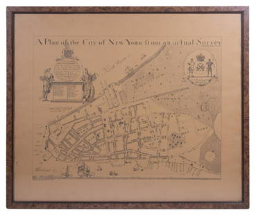
Sold2023REPLICA OF LAING'S MAP OF MANHATTAN"A Plan of the City of New York from an actual Survey" for His Excellency John Montgomerie, by William Bradford, printed on tan paper, in a faux tortoiseshell frame, under glass, 23" x 26", good condiSee Sold Price
Sold2023M. Dripps 1860 Map New York City County & Vacinity By M. DrippsM. Dripps 1860 Map New York City County & Vacinity By M. Dripps 22.5" x 30"See Sold Price
Sold2022Encyclo. Britannica C1880 Lot 3 Maps. New York City & StateTwo City Plans and a State Map. Lithograph Maps Published 1875-98, Edinburgh & London for "Encyclopaedia Britannica" Ninth Edition. Paper Size: 10.5 x 8 inch (27 x 21cm) and 15.5 x 10.5 inch (39 x 27cSee Sold Price
Sold2021c 1730 Seutter Map: Novi Belgii, in America ...Historic Maps c. 1730 Historic Rare Earlier State of Seutter's Important American Northeast Map & New York City Restitutio View c. 1730 Hand-Colored Copper-Engraved Map titled, "Recens Edita totius NoSee Sold Price
Sold2019Large map, New York City's UWS, 1879Large map, New York City's UWS, 1879, "West End Plateau of New York" by Herman K. Viele, City Surveyor, printed by Johnson & Pratt, New York, 1879, framed under acrylic, with 25-page booklet in pocketSee Sold Price
Sold2021INVADER 'Invasion Map NYC' Lithograph Print'Invasion Map New York City' by Invader, 2003 16.5 x 23.6 Inches Offset lithograph on fine art paper. Open edition (Sold Out). Mint Condition. Ships folded. ARTIST BIO Invader is one of the most enSee Sold Price
Sold20171865 Colton New York City Map1865 Colton New York City Map -- New York City Brooklyn, Jersey City, Hoboken, Etc. C. B. Colton 1865 New York 24 x 17 in. This nice map of New York City, including Manhattan, Brooklyn, Jersey City anSee Sold Price
Sold2016Gray & Son's Map of New York City 1876Map: New York City, Brooklyn, Jersey City, Hoboken, Etc. Maker: O.W. Gray & Son, Ormando W. Gray & Frank H. Gray Size: Double Folio - 23 inches high x 16.3 inches wide Date: 1876 Detailed map of New YSee Sold Price
Sold2017Tanner: Antique Map of New York City, 1843Title/Content of Map: New York City by Tanner Date Printed: 1843 Cartographer: based on the work of H.C. Tanner Material/Medium: Paper Size: 17" x 14" Hand colored engraved Map. From the first editionSee Sold Price
Sold2017Map of New York City[ANTIQUARIAN MAP; NEW YORK CITY] MAP OF NEW YORK CITY Showing Portions of Brooklyn, Jersey City, and Westchester Co., Rand-McNally & Co., 1899, original large map 27” high x 22” across including aSee Sold Price
Sold2017Mitchell: Antique Map of New York City, 1869Title/Content of Map: New York City by Mitchell Date Printed: 1869 Cartographer: Augustus S. Mitchell Material/Medium: Paper Size: 23" x 15" Condition: Excellent Hand colored engraved Map. Published iSee Sold Price
Sold2020New York City Subway Travel1992Title/ Content of Map:New York City Subway Travel1992 Date Printed: 1992 Cartographer: Material/Medium: paper Dimensions: 15-fold. approx. 18.5x 22 inches open, 4x7.5 inches folded. Additional InformaSee Sold Price
Sold2024Pre-Central Park Map of New York City, David H. Burr / Simeon DeWitt 1829Sight size 21" x 50.5" framed to 24.75" x 54.5". Some tears and seams with attempts at repair, foxing and toning, not examined out of frame.See Sold Price
Sold2021Scarce SDUK map of New York City, 1840Elusive vintage 1840 Society for the Diffusion of Useful Knowledge (S.D.U.K.) city map or plan of New York City. Shows southern Manhattan from the Battery northwards to 42nd Street and portions of adjSee Sold Price
Sold20171779 Map of New York City. Sauthier. One section.1779 Map of New York City. Sauthier. One section. Sauthier s map of New York summarizes much of the British military mapping done in the years preceding the revolution. Sautier himself typifies the muSee Sold Price
Sold2020Grp: 10 Maps of New York City 18th-Early 20th c.Group of 18th to early 20th century maps of New York City. Multiple are 19th-20th c. reprints of 17th-18th c. maps. Includes a small census map of New York City from 1850 with populations of New YorkSee Sold Price
Sold20221828 MAP of New York City Suburbs Railroads New Jersey EC Bridgman Color1828 MAP of New York City Suburbs Railroads New Jersey EC Bridgman Color An impressive, 19th-century map of New York City and its surrounding environs. This E.C. Bridgman map is a huge map folded intoSee Sold Price
Sold2021Hayward Map of New York City -- A Plan of the City ofTitle: Hayward Map of New York City -- A Plan of the City of New York & its Environs to Greenwich … Cartographer: J Hayward / Valentine's manual Year / Place: 1855, New York Map Dimension (in.): 24.See Sold Price
Sold2017Map Of New York CityFramed map of New York City, published by Jeffries And Faden, London. [Overall: 28" x 38"]. Not examined out of frame.See Sold Price
Sold20181807 Marshall Map Showing New York City in 1776 -- IleTitle/Content of Map: 1807 Marshall Map Showing New York City in 1776 -- Ile de New-York. Partie de Long-Island ou de l'Ile Longue, et Positions des Armees Americaine et Britannique, apres le Combat LSee Sold Price
Sold2023Impressive 1865 map of New York City by Johnson & WardJohnson and Ward’s great horizontal format of Manhattan and surrounding boroughs at the close of the Civil War. This double-page map shows great detail in Central Park and throughout with many eSee Sold Price
May 19The Heritage Gallery at Sayville Antiques, IncWPA Style O/C NYC View Lower Manhattan From Staten Island$110(2 bids)
May 11Freeman's | HindmanClaes Oldenburg (American, 1929-2022) - Proposed Colossal Monument for Staten Island, New York City$9,000
Jun 09Estate Collection Auctioneer1986 Photo The Staten Island Anchorage viewed from Narrows Bridge Tower$250
1 day LeftRapid Estate Liquidators and Auction GalleryBoy Scout Council Shoulder Badges Lot Of 24 C$85
May 16Potter & Potter Auctions[NEW YORK CITY – PICTORIAL MAPS]. Group of 3 pictorial maps...$200(1 bid)
332 Lots AwayBucklinLyon, Danny; The Destruction of Lower Manhattan [1969 1ST EDITION & 1ST PRINTING HARDCOVER W/ DUST$120(3 bids)


![Map of New York City: [ANTIQUARIAN MAP; NEW YORK CITY] MAP OF NEW YORK CITY Showing Portions of Brooklyn, Jersey City, and Westchester Co., Rand-McNally & Co., 1899, original large map 27” high x 22” across including a](https://p1.liveauctioneers.com/1163/104811/53672586_1_x.jpg?height=310&quality=70&version=1496428876)


![Map Of New York City: Framed map of New York City, published by Jeffries And Faden, London. [Overall: 28" x 38"]. Not examined out of frame.](https://p1.liveauctioneers.com/1221/99073/50623249_1_x.jpg?height=310&quality=70&version=1485457575)


![[NEW YORK CITY – PICTORIAL MAPS]. Group of 3 pictorial maps... (1 of 3)](https://p1.liveauctioneers.com/928/325952/175495562_1_x.jpg?height=282&quality=70&version=1712935174)


