Sold2022Set of Chinese Famille Rose Saucers w/ butterflyA set of Chinese famille rose saucers with butterfly design. Set into a square shaped wooden box, nine famille rose saucers are arranged into an inner square shape at a 45 degree angle to the sides. ESee Sold Price
Sold2018Mercator map of the North Pole 1619Heading: Author: Mercator, Gerard Title: Septentrionalium Terrarum descriptio Place Published: Amsterdam Publisher: Date Published: 1595-[1619] Description: Copper-engravedSee Sold Price
Sold2022C. S. Hammond & Co. 18 Inch Terrestrial Globe on StandC.S. Hammond & Company (American, 1900-2010) 18" terrestrial globe, housed in a brass meridian ring with brass hour circles at North and South Poles, with a horizon band listing the months of the yearSee Sold Price
Sold202130 inch Terrestrial Globe, W. & A.K. Johnston30 inch Terrestrial Globe, W. & A.K. Johnston. Limited. Geographers, engravers & printers. Edinburgh & London, having a time dial to the North and South Poles, a brass full-ring Meridian mounted on beSee Sold Price
Sold2021C.S. HAMMOND & CO. 18" TERRESTRIAL GLOBE. C.1920C.S. Hammond & Co. (American, 1900-2010), 1915-1925. 18" terrestrial globe in a brass meridian ring with hour circles at North and South Poles, having a horizon band noting the months of the year andSee Sold Price
Sold2018McCORMICK, Robert (1800-1890). Voyages of Discovery inMcCORMICK, Robert (1800-1890). Voyages of Discovery in the Arctic and Antarctic Seas, and Round the World; being the personal narratives of attempts to reach The North and South Poles; and of an Open-See Sold Price
Sold2022De Wit, Map of North and South America, c. 1720Property of a Private Collector, Hilton Head Island, SC Description: Frederick De Wit (circa 1629-1706), Nova Orbis Tabula In Lucem Edita, A.F. De Wit, Amsterdam: Covens and Mortier, c. 1720, publSee Sold Price
Sold2017Mouzon Map of CarolinasAn Accurate Map of North and South Carolina, with their Indian Frontiers, Shewing in a distinct manner all the Mountains, Rivers, Swamps, Marshes, Bays, Creeks, Harbours, Sandbanks and Soundings on thSee Sold Price
Sold2015Munster. TABULA NOVARUM INSULARUM... [c. 1558-59.][Munster, Sebastian] TABULA NOVARUM INSULARUM, QUAS DIVERSIS RESPECTIBUS OCCIDENTALES & INDIANAS UOCANT. Double-page woodcut map of North and South America by Sebastian Munster. First cut in 1540, thiSee Sold Price
Sold2022(AMERICAS.) Sebastian Münster. Die Neuwen Inseln. So Hinder Hispanien Gegeu Orient Bey Dem Land(AMERICAS.) Sebastian Münster. Die Neuwen Inseln. So Hinder Hispanien Gegeu Orient Bey Dem Land India Ligen. Hand-colored double-page woodcut map of North and South America. 12x15 inches sheet siSee Sold Price
Sold20222-sheet map of ancient Egypt by Ortelius 1584Heading: Author: Ortelius, Abraham Title: Aegyptus Antiqua Place Published: Antwerp Publisher: Date Published: 1584 Description: Copper engraved map on two sheets, north anSee Sold Price
Sold2022London.- Booth (Charles) Descriptive Map of London Poverty 1889, in four parts, 1889London.- Booth (Charles) Descriptive Map of London Poverty 1889, in four parts covering the North-Western, South-Western, North-Eastern, and South Eastern parts of London, based on Stanford's 'LibrarySee Sold Price
Sold2017America, Rare Early Map of the Americas"America", Rare Early Map of the Americas by Jodocus Hondius (Flemish/Dutch, 1563-1612) for a French edition of Mercator's Atlas, North and South America, hand-colored copper engraved map, published ASee Sold Price
Sold2016Varamin Mafrash Side PanelSecond half 19th century, 45 x 110 cm, North Persia During the 19th century, a number of tribal groups (Luri, Afshar, Shahsavan et al.) led a semi-nomadic life on the Varamin plain situated south of TSee Sold Price
Sold2018South East Asia.- Ortelius (Abraham) Indiae OrientalisSouth East Asia.- Ortelius (Abraham) Indiae Orientalis Insularumque Adiacientium Typus, map of southern Asia from India across to Java and New Guinea, and including China and Japan to the north, withSee Sold Price
Sold2022Circular Bank/Hotel Foyer Cabinet By Phillip KoppCircular Bank/Hotel Foyer Cabinet By Phillip Kopp, 105” x 63" Diameter, Made In 1850, Burl Walnut, Two Tiered, Four Sections Of White Marble With Mirrors Set At 90 Degree Angles, Sixteen LockablSee Sold Price
Sold2020PR OF EARLY QING IMPERIAL GLAZED EARTHENWARE ROOF TILESPair of Large Scale Chinese Amber Glazed Dragon Head Form Imperial Roof Tiles, 45 degree mount brackets, with open mouths, lacking the lower jaws, which were cast separately, 20" x 9" x 19". Minor losSee Sold Price
Sold2021Exceptional unused 1936 model bluebill drake, WardExceptional unused 1936 model bluebill drake, Ward Brothers, Crisfield, Maryland. Very bold original paint with heavy stippling on back and sides. Head is turned 45 degrees to one side. 14.5" long. VLSee Sold Price
Sold2016Richard MacDonald Bronze Figure of a GymnastBronze Figure of an Olympic Gymnast. The gymnast cast mid-performance on an Olympic ring; his legs at a 90 degree angle, the left leg vertical and the right leg horizontal. Inscribed on base: To EdwarSee Sold Price
Sold2020Joan Miro 1893-1983 SIGNED Mannequin Parade LithoJoan Miro (Spanish, 1893-1983). Signed and numbered Limited Edition lithograph print on paper, "Mannequin Parade at the North Pole," published in colors circa 1969 by Maeght, Paris on wove paper. ArtiSee Sold Price
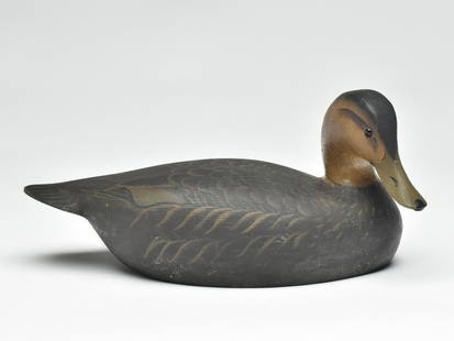
Sold2022Black duck, Ward Brothers, Crisfield, Maryland.Black duck, Ward Brothers, Crisfield, Maryland. Hollow carved shooting stool model with head turned approximate 45 degrees. Signed and dated 1965 on underside. Measures 14.5" long.See Sold Price
Sold20201761 MAP OF NORTH AMERICA BY ROCQUE18th century map GENERAL MAP OF NORTH AMERICA 1754-1761 by John Rocque, London by A. Drury, 2 part map, 35.5 x 36 inches, good condition.See Sold Price
Sold2016Map of North America...David H. Vance, engraved by J.H. Young. Philadelphia: Anthony Finley, 1825. Engraved map in 5 parts with original hand color in outline. 25 7/8 x 20 1/2 inches sheet, 30 5/8 x 25 1/2 inches framed.See Sold Price
Sold2021FRAMED J.H. COLTON MAP OF NORTH AMERICA CA INSETFramed engraving on paper, Map of North America from the Latest Authorities, published by J.H. Colton (Joseph Hutchins Colton, 1800-1893), No. 86 Cedar St., New York, 1846, drawn and engraved by J.M.See Sold Price
3 days LeftFreeman's | Hindman[Maps & Atlases] Seutter, Matth(ias).: Novus Orbis sive America...$300(1 bid)
6 days LeftLeland LittleEmanuel Bowen (English, 1697-1767), Map of the American Southeast$100(2 bids)
3 days LeftJasper521775 d'Apres de Mannevillette Map of South African Coast -- Carte Reduite de la Cote Meridionale$190
Jul 06Case Antiques, Inc. Auctions & AppraisalsColton's Atlas of the World, 1856, in Two Volumes; plus Africa / Mahdist War Map$500(1 bid)
Featured3 days LeftJasper521702 Homann Map of Northern Italy, Milan Included -- Belli Typus in Italia…$160
Featured3 days LeftJasper521645 Jansson Map of Portugal and Parts of Spain -- Portugallia et Algarbia quae olim Lusitania$200
19 hrs LeftLeonard Auction, a division of The Leonard CompanyAfrican Ethnographic Object Assortment$150(1 bid)
BonhamsPEARY'S COPY OF AN EARLY NORTH AMERICAN MAP. PEARY, ROBERT E. 1856-1920.] DOBBS, ARTHUR. 1689-17...$100(1 bid)
Jul 14Schilb Antiquarian Rare Books1819 COLUMBUS 1ed America Magellan USA Washington Cortez MAPS Revolutionary War$70(4 bids)
5 days LeftJulien's AuctionsDuke of Kent | 1900 Commemorative Linen Scarf With South Africa Map And Poem$50
3 days LeftJasper521930 Map of Hollywood, California -- Security-First National Bank Map of Hollywood and Vicinity$280


![Mercator map of the North Pole 1619: Heading: Author: Mercator, Gerard Title: Septentrionalium Terrarum descriptio Place Published: Amsterdam Publisher: Date Published: 1595-[1619] Description: Copper-engraved](https://p1.liveauctioneers.com/642/122092/62169135_1_x.jpg?height=310&quality=70&version=1526256630)


![Munster. TABULA NOVARUM INSULARUM... [c. 1558-59.]: [Munster, Sebastian] TABULA NOVARUM INSULARUM, QUAS DIVERSIS RESPECTIBUS OCCIDENTALES & INDIANAS UOCANT. Double-page woodcut map of North and South America by Sebastian Munster. First cut in 1540, thi](https://p1.liveauctioneers.com/179/82189/42599755_1_x.jpg?height=310&quality=70&version=1447864785)


![[Maps & Atlases] Seutter, Matth(ias).: Novus Orbis sive America... (1 of 2)](https://p1.liveauctioneers.com/65/332523/179335174_1_x.jpg?height=282&quality=70&version=1717709447)


![PEARY'S COPY OF AN EARLY NORTH AMERICAN MAP. PEARY, ROBERT E. 1856-1920.] DOBBS, ARTHUR. 1689-17... (1 of 3)](https://p1.liveauctioneers.com/1043/333441/180036747_1_x.jpg?height=282&quality=70&version=1718642562)


