Sold2022c. 1781 Captain Cook Voyages Map, London by Alexander HoggHistoric Maps "A Plan of Success Bay in Strait Le Maire / A Chart of the S.E. part of Terra del Fuego... by Captn. Cook 1769" c. 1781, Dual Map from Captain Cook's Voyages, titled: "A Plan of SuccessSee Sold Price
Sold2022c. 1781 Captain Cook Voyages Map, London by Alexander HoggHistoric Maps "A Plan of Success Bay in Strait Le Maire / A Chart of the S.E. part of Terra del Fuego... by Captn. Cook 1769" c. 1781, A "Dual" Map from Captain Cook's Voyages, titled: "A Plan of SuccSee Sold Price
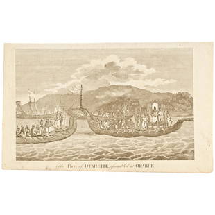
Sold2020c 1781 Engraved Print Captain James Cook's VoyagePrints Capt. James Cook "The Fleet of Otaheite, assembled at Oparee" c. 1781, Engraved Print titled, "The Fleet of Otaheite, assembled at Oparee", Very Fine. Overall size 9.25" x 15". Published in LonSee Sold Price
Sold2020c 1781 Captain James Cook Illustration PrintPrints c. 1781 Captain James Cook Engraved Illustration Print c. 1781, Engraved Print, "A Chief and other Natives of O-Taheitee, visiting Captn. Cook in his second Voyage to the Southern Hemisphere",See Sold Price
Sold2022Extraordinary Book of Engravings from Captain Cook's Voyages, c. 1784First Edition, c. 1784. 60 copperplate engravings drawn by John Webber (1751-1793) on chain-laid paper. Depicting images from the three voyages of Captain Cook. Contains a foldout map at the rear. PrSee Sold Price
Sold2022Antique Map Print of Oceania - Map of Madeira & The Azores - 1870 - James CookOriginal Antique Decorative Map of Madeira & The Azores, Fullarton, C.1870 This fascinating folio engraving is from Captain James Cook & James King's "A Voyage to the Pacific Ocean, for making DiscoveSee Sold Price
Sold2017Cooks Voyages with maps by TallisHeading: Author: Cook, James Title: The Voyages of Captain James Cook Round the World Place Published: London & New York Publisher:James Tallis & Company Date Published: c.1860 DescripSee Sold Price
2017Tallis/Rapkin: Antique Map of Captain Cook's VoyageTitle/Content of Map: 'The World on Mercator's Projection shewing the voyages of Captain Cook around the World' The track's of Cook's first, second and third voyages are shown, along with dates. DateSee Sold Price
Sold2021Antique Map of Captain James Cook's Voyages to theAntique map of Captain James Cook's voyages to the Pacific region. Captain Cook made numerous discoveries in the Pacific region during the late 1700's . Artists and mapmakers aboard the ship, includinSee Sold Price
Sold201918th C. Engraving Captain Cook by J Webber18th C. Engraving from Captain Cook's Voyages by J Webber depicting a man of the Sandwich Islands wearing a mask. Sight size is approx. 11" inches by 9" inches. Overall size is approx. 21" inches by 1See Sold Price
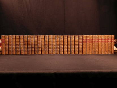
Sold20181780 1ed RARE Complete VOYAGES Maps Captain Cook Americ1780 1ed RARE Complete VOYAGES Maps Captain Cook America Explorers Africa 32v The best book of its kind! An extremely rare, 32-volume complete set of La Harpe’s ‘General History of Voyages’! ThiSee Sold Price
Sold20181780 1ed RARE Complete VOYAGES Maps Captain Cook1780 1ed RARE Complete VOYAGES Maps Captain Cook America Explorers Africa 32v The best book of its kind! An extremely rare, 32-volume complete set of La Harpe’s ‘General History of Voyages’! ThiSee Sold Price
Sold20181780 1ed VOYAGES Captain Cook Maps Comm Byron America1780 1ed VOYAGES Captain Cook Maps Comm Byron America Explorers Africa 3v La Harpe The best book of its kind! A rare set of La Harpe’s ‘General History of Voyages’! This extensive work was begunSee Sold Price
Sold20221836 1ed Oceania Rienzi Polynesia Voyages MAPS Australia Captain Cook Pacific1836 1ed Oceania Rienzi Polynesia Voyages MAPS Australia Captain Cook Pacific Louis de Rienzi was a 19th-century French voyager who is remembered for his 1836 masterwork Oceania, or Fifth Part of theSee Sold Price
Sold20191836 1ed Oceania Rienzi Polynesia Voyages MAPS1836 1ed Oceania Rienzi Polynesia Voyages MAPS Australia Captain Cook Pacific Louis de Rienzi was a 19th-century French voyager who is remembered for his 1836 masterwork ‘Oceania, or Fifth Part of tSee Sold Price
Sold201918th C. Engraving of Sandwich Island Man Capt Cook18th C. Engraving of Sandwich Island Man from Captain Cook's Voyages in the Pacific Ocean, engraving by J. Webber. Overall measurement is 21" inches by 15" inches and the sight size is approx. 11" incSee Sold Price
Sold2023La Mappe Monde- Map of 3 Voyages of Captain CookAntique Map Print- La Mappe Monde, Depicting the Three Voyages of Captain Cook. Original was Drawn by Herisson, Hand Watercolored, Number 64 and Dated 1816. Measures 33 1/2" x 47" framed. Good ConditiSee Sold Price
Sold20211774 1ed Voyages Captain Cook Pacific Ocean Wallis C.1774 1ed Voyages Captain Cook Pacific Ocean Wallis Carteret Hawaii Hawkesworth 2v John Hawkesworth was an important English book editor, most known for his commission to edit Captain James Cooks VoyagSee Sold Price
Sold2024[VELLUM DEEDS, MAPS] COOK, ROWLANDSON, ETC. 100+VELLUM DEEDS, MAPS, ENGRAVINGS. A lot of approximately 100+ pieces sold together. Condition and sizes vary. Maps of China, Africa, Pacific; engraved plates from CAPTAIN COOK'S VOYAGE (late 1700s); engSee Sold Price
Sold2023C. 1779, ANTARCTICA & CAPTAIN COOK'S TRAVELS MAPAntonio Zatta (Italian fl. 1775-1797), "Emisfero Terrestre Meridionale Tagliato su l'Equatore", circa 1779, hand colored etching on paper depicting map of Antarctica and Captain Cook's travels, unframSee Sold Price
Sold2016Voyages.- Cook (Captain James), Troisieme Voyage deVoyages.- Cook (Capt. James) Troisieme Voyage de Cook, ou Voyage a l'Ocean Pacifique, 9 vol. (including Atlas), first French edition, 8 text vol. with half-titles, Atlas with 88 engraved maps and platSee Sold Price
Sold2022Royal Doulton Australian Two Handled VaseLarge black basalt loving cup with a relief of the British explorer Captain Cook and his voyage to Australia. Royal Doulton backstamp. #RoyalDoulton #BlackBasalt #Australia Issued: c. 1901 - 1922 DimeSee Sold Price
Sold2015Lg Framed early 19th c. Map of the WorldLg Framed early 19th c. Map of the World, "Mappe Monde", Indication des trois voyages du Capitaine Cook, French 1816 in floral gilt 32" x 46" frame Condition; was folded, some wear along fold lines frSee Sold Price
Sold20241783 Captain James Cook Third Pacific Voyage Illustrated MAP Australia Rickman1783 Captain James Cook Third Pacific Voyage Illustrated MAP Australia Rickman “Remember, the greater the opportunity, the fewer are those who see it.” – James Cook James Cook was an 18th-ceSee Sold Price
Jun 02Schilb Antiquarian Rare Books1880 Captain James Cook Voyages Hawaii Pacific Australia Kippis South Sea Navy$50(3 bids)
5 days LeftJasper521723 Dampier Map of Voyages to Brazil, Australia and Eat Indies -- Voyage du Cap. Dampier a la N.$280
Jun 07Freeman's | HindmanCOOK, James, Captain. -- [SECOND VOYAGE]. A Voyage towards the South Pole, and Round the World...$1,500
6 days LeftJasper52Extremité Meridionale de l'Amérique Tierra del Fuego Magellan Str BONNE 1788 map$35
Jun 08Early American History AuctionsFrench and Indian War 1758 CT. Fiscal Document Signed Joseph Talcott Treasurer to Repay John Ledyard$1,400
6 days LeftJasper52Détroit de Magellan. Strait of Magellan. Chile. BONNE 1790 old antique map$30
6 days LeftJasper52Détroit de Magellan. Strait of Magellan. Chile. BONNE 1788 old antique map$30
Jun 08Early American History Auctionsc 1730 Hand-Colored Colonial Era Map of the Americas, California shown as an Island, Matted + Framed$500(1 bid)
Jun 09Austin Auction GalleryELIZABETH II SILVER PENINSULAR & ORIENTAL STEAM NAVIGATION CO. PRESENTATION SALVER$300
Echoes of Glory International Military Auction HouseNotorious US Navy Captain Robert C. Klosterman's HELLRAZOR Flight Suit(KDW)$11(4 bids)
Echoes of Glory International Military Auction HouseNotorious Captain Robert C. Klosterman's Aircraft Carrier USS Stennis Commissioning Plaque (KDW)$160(15 bids)


![[VELLUM DEEDS, MAPS] COOK, ROWLANDSON, ETC. 100+: VELLUM DEEDS, MAPS, ENGRAVINGS. A lot of approximately 100+ pieces sold together. Condition and sizes vary. Maps of China, Africa, Pacific; engraved plates from CAPTAIN COOK'S VOYAGE (late 1700s); eng](https://p1.liveauctioneers.com/8124/322212/173234973_1_x.jpg?height=310&quality=70&version=1709937662)


![COOK, James, Captain. -- [SECOND VOYAGE]. A Voyage towards the South Pole, and Round the World... (1 of 2)](https://p1.liveauctioneers.com/197/329395/177650491_1_x.jpg?height=282&quality=70&version=1715364962)


