Sold20181700 Pacific sea chart with Island of California andTitle: Mer de Sud ou Pacifique contenant l'Isle de Californe. Map maker: Pierre Mortier Place and Year: Amsterdam, 1700 Dimensions: 60 x 74.5 cm (23.6 x 29.3 in) Technique: Copperplate engraving ColorSee Sold Price
Sold2015Magnum Mare del Zur cum InsulaCalifornia by Frederick de Wit (1630-1706), Amsterdam, 1675, copper-engraved mariner's chart, hand-colored in outline, showing California as an island, Tooley #40, with a colorful pictorial cartoucheSee Sold Price
Sold2018c. 1650 Map: Mar del Zur Hispanis Mare PacificumHistoric Maps c. 1650 Hand-Colored Map "Mar del Zur Hispanis Mare Pacificum" by Joannes Jansson with California as an Island Earliest Pacific Sea Chart of the to Appear in a Dutch Atlas c. 1650, Hand-See Sold Price
Sold2021Nautical Map / Sea Chart, #362 Block Island Sound andDescription: Nautical Map / Sea Chart, United States East Coast, New York, Long Island, Block Island Sound and Gardiner's Bay, 6th edition, Feb 10/69; Shipping: $20; different rate to California, AlasSee Sold Price
Sold20231790 George Anson World Voyage Spain South America HUGE MAP California Island1790 George Anson World Voyage Spain South America HUGE MAP California Island George Anson was an 18th-century British Navy admiral who is noted for his important world voyage in which he circumnavigaSee Sold Price
Sold20181768 Geography ATLAS MAPS California Island Asia China1768 Geography ATLAS MAPS California Island Asia China 17 MAPS A rare 18th-century geographical treatise by Jean Baptiste Gibrat. This work features 17 impressive folding, engraved maps. Little is knoSee Sold Price
Sold2022Southern California Islands Photo Booklet [142807]This booklet is a photographic copy of an original album of 28 B& W photos of Southern California island scenes entitled Our Log. The original photos and hand-drawn illustrations appear to record an 1See Sold Price
Sold2023Williamson, Lieut. R. S. 1856 LG Chart. California - Bernardino Sierra, San Pedro"Geological Section of the Bernardino Sierra from the Great Basin to the Pacific ocean at San Pedro" by William P. Blake. Lithograph Map Published 1853-61, Washington for "Reports of explorations andSee Sold Price
Sold2023Williamson, Lieut. R. S. 1856 LG Chart. California - Sierra Nevada, Tulare Valley etc"Geological Section along the Tejon Ravine from the Tulare Valley and the Tejon Depot Camp to Taheechaypah Prairie" "Geological Section of the Sierra Nevada at the Canada de las Uvas" by William P. BlSee Sold Price
Sold2023Williamson, Lieut. R. S. 1856 LG Chart. California - Colorado River to the Pacific Ocean"Geological Section from the Colorado River to the Pacific Ocean" by William P. Blake. Lithograph Map Published 1853-61, Washington for "Reports of explorations and surveys, to ascertain the most pracSee Sold Price
Sold2023Williamson, Lieut. R. S. 1856 LG Chart. California - Coast Mountains & Sierra Nevada"Geological Section of the Coast Mountains and Sierra Nevada" by W. P. Blake. Lithograph Map Published 1853-61, Washington for "Reports of explorations and surveys, to ascertain the most practicable aSee Sold Price
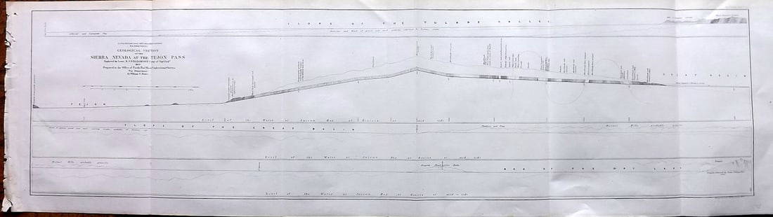
Sold2023Williamson, Lieut. R. S. 1856 LG Chart. California - Sierra Nevada & Tejon Pass"Goelogical Section of the Sierra Nevada at the Tejon Pass" by R. S. Williamson. Lithograph Map Published 1853-61, Washington for "Reports of explorations and surveys, to ascertain the most practicablSee Sold Price
Sold2023Williamson, Lieut. R. S. 1856 LG Chart. California - Bernadino Pass, San Bernardino, Colorado Desert"Geological Sections of the Bernadino Pass" Lithograph Map Published 1853-61, Washington for "Reports of explorations and surveys, to ascertain the most practicable and economical route for a railroadSee Sold Price
Sold2023Williamson, Lieut. R. S. 1856 LG Chart. California - Colorado Desert"Sections of the Colorado Desert" Explored by Lieut R. S. Williamson. Lithograph Map Published 1853-61, Washington for "Reports of explorations and surveys, to ascertain the most practicable and econoSee Sold Price
Sold20201711 MAPS Atlas Geography Africa Asia America1711 MAPS Atlas Geography Africa Asia America California Island France Buffier Claude Buffier was a 17th-century French historian who published works on metaphysics, grammar, and, most notably, univerSee Sold Price
Sold20201759 Geography 18 Maps ATLAS Africa Italy Asia America1759 Geography 18 Maps ATLAS Africa Italy Asia America California Island Buffier Known primarily for his contributions to philosophy, Claude Buffier, a 17th-century French Jesuit historian, publishedSee Sold Price
Sold2021Group of tax rate signs, maps, magazinesPause for Living, Michigan sales tax chart, California and Oregon mapsSee Sold Price
Sold2020Hondius' North America California an IslandHeading: Author: Hondius, Henricus Title: America Septentrionalis Place Published: Amsterdam Publisher: Date Published: 1636-[1639] Description: Copper-engraved map, lightly hanSee Sold Price
Sold2020Seutter's America, California an islandHeading: Author: Seutter, Matthew Title: Novus Orbis Sive America Meridionalis et Septentrionalis per sua Regna, Provincias et Insulas Iuxta Observationes et Descriptiones Resentiss. Divisa et AdornaSee Sold Price
Sold2017Allard Map of America with California as Island, 1697Map: Allard Map of America with California as Island - Recentissima Novi Orbis sive Americae Septentrionalis et Meridionalis Tabula Cartographer: C. Allard Date: ca. 1697 Size: 19 x 22.5 inches Nice lSee Sold Price
Sold2021Kerry Hallam Acrylic on Coastal Chart - Long IslandKerry Hallam (British 1937-2020) Acrylic on Coastal Chart - Long Island Sound, Nantucket Sound and New England Coastline, signed lower left 26 in. x 43.5 in. Overall 29.5 in. x 47.5 in. Dimensions 26See Sold Price
Sold2020Sanson's North America, California an islandHeading: Author: Sanson, Guillaume Title: Amerique Septentrionale Place Published: Paris Publisher:Chez Pierre Mariette Date Published: 1669 Description: Copper-engraved maSee Sold Price
Sold2020Seale map of North America California an islandHeading: Author: Seale, Richard William Title: A Map of North America with the European Settlements & whatever else is remarkable in ye West Indies, from the latest and best Observations Place PublisSee Sold Price
Sold2015America by Lotter, 1760 (California as Island)Copper engraving by Lotter, 1760. Significant pre-revolutionary map that features the idea of California as an island. Also, the British colonies are shown extending to the Mississippi River. UnframedSee Sold Price
Jun 07Holabird Western Americana CollectionsWilmington Transportation Co passes, 1906/111 [179538]$50
Jun 07Holabird Western Americana CollectionsMap of Mare Island Straits California by Bache, 1851 [179999]$50
6 days LeftHolabird Western Americana CollectionsCalifornia as an Island by Leighly, The Book Club of California [182233]$150
Jun 07Freeman's | HindmanWATSON, George R.. "Glenn Martin to Test-Fly "Pusher" Curtis Single Engine". C. 1920-1929 (printed$100
Jun 08Early American History Auctionsc 1730 Hand-Colored Colonial Era Map of the Americas, California shown as an Island, Matted + Framed$500(1 bid)
Jun 08Leon GalleryJodocus Hondius 1606 (Jodocus Hondius and Cornelis Claesz) - India Orientalis₱40,000


![Southern California Islands Photo Booklet [142807]: This booklet is a photographic copy of an original album of 28 B& W photos of Southern California island scenes entitled Our Log. The original photos and hand-drawn illustrations appear to record an 1](https://p1.liveauctioneers.com/2699/237258/122967265_1_x.jpg?height=310&quality=70&version=1644622775)


![Hondius' North America California an Island: Heading: Author: Hondius, Henricus Title: America Septentrionalis Place Published: Amsterdam Publisher: Date Published: 1636-[1639] Description: Copper-engraved map, lightly han](https://p1.liveauctioneers.com/642/174090/87617777_1_x.jpg?height=310&quality=70&version=1595023143)


![Wilmington Transportation Co passes, 1906/111 [179538] (1 of 2)](https://p1.liveauctioneers.com/2699/331495/178786260_1_x.jpg?height=282&quality=70&version=1717094933)
![Map of Mare Island Straits California by Bache, 1851 [179999] (1 of 1)](https://p1.liveauctioneers.com/2699/331495/178785781_1_x.jpg?height=282&quality=70&version=1717094933)
![California as an Island by Leighly, The Book Club of California [182233] (1 of 8)](https://p1.liveauctioneers.com/2699/331494/178785512_1_x.jpg?height=282&quality=70&version=1717094654)


