Sold2023Williamson, Lieut. R. S. 1856 LG Chart. California - Coast Mountains & Sierra Nevada"Geological Section of the Coast Mountains and Sierra Nevada" by W. P. Blake. Lithograph Map Published 1853-61, Washington for "Reports of explorations and surveys, to ascertain the most practicable aSee Sold Price
Sold2023Williamson, Lieut. R. S. 1856 LG Chart. California - Sierra Nevada, Tulare Valley etc"Geological Section along the Tejon Ravine from the Tulare Valley and the Tejon Depot Camp to Taheechaypah Prairie" "Geological Section of the Sierra Nevada at the Canada de las Uvas" by William P. BlSee Sold Price
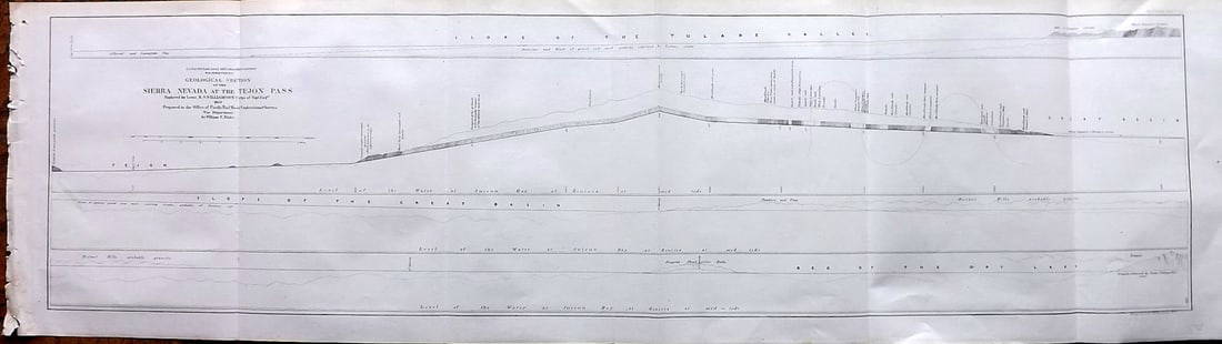
Sold2023Williamson, Lieut. R. S. 1856 LG Chart. California - Sierra Nevada & Tejon Pass"Goelogical Section of the Sierra Nevada at the Tejon Pass" by R. S. Williamson. Lithograph Map Published 1853-61, Washington for "Reports of explorations and surveys, to ascertain the most practicablSee Sold Price
Sold2023Williamson, Lieut. R. S. 1856 LG Chart. California - Bernardino Sierra, San Pedro"Geological Section of the Bernardino Sierra from the Great Basin to the Pacific ocean at San Pedro" by William P. Blake. Lithograph Map Published 1853-61, Washington for "Reports of explorations andSee Sold Price
Sold2023Williamson, Lieut. R. S. 1856 LG Chart. California - Colorado River to the Pacific Ocean"Geological Section from the Colorado River to the Pacific Ocean" by William P. Blake. Lithograph Map Published 1853-61, Washington for "Reports of explorations and surveys, to ascertain the most pracSee Sold Price
Sold2023Williamson, Lieut. R. S. 1856 LG Chart. California - Bernadino Pass, San Bernardino, Colorado Desert"Geological Sections of the Bernadino Pass" Lithograph Map Published 1853-61, Washington for "Reports of explorations and surveys, to ascertain the most practicable and economical route for a railroadSee Sold Price
Sold2023Williamson, Lieut. R. S. 1856 LG Chart. California - Colorado Desert"Sections of the Colorado Desert" Explored by Lieut R. S. Williamson. Lithograph Map Published 1853-61, Washington for "Reports of explorations and surveys, to ascertain the most practicable and econoSee Sold Price
Sold2020California 1856 Lot of 7 Large Railroad Survey ChartsIncl Sierra Nevada, Tejon Pass, Tejon Ravine, Bernardino Sierra/San Pedro, Colorado Desert, Bernardino Pass, Colorado River, and Coast Mountains from San Francisco to the Great Basin. Lithographs PublSee Sold Price
Sold2023Williamson, Lieut. R. S. 1856 LG HC Map. California - First Geological Map"Geological Map of a Part of the State of California" Explored in 1855 by Lieut R. S. Williamson. Prepared to accompany the Report of William P. Blake. THE FIRST GEOLOGY MAP OF CALIFORNIA. Hand ColoreSee Sold Price
Sold2023Williamson, Lieut. R. S. 1856 Map. California, New Mexico, Texas, Mexico"United States & Mexican Boundary Survery" Lithograph Map Published 1853-61, Washington for "Reports of explorations and surveys, to ascertain the most practicable and economical route for a railroadSee Sold Price
Sold2023Williamson, Lieut. R. S. 1856 Map. California - Tejon Pass & Canada de las Uvas"Geological Map of the Tejon Pass & Canada de las Uvas and the Vicinity. Including the Pass of San Francisco & Williamsons Pass"Lithograph Map Published 1853-61, Washington for "Reports of explorationSee Sold Price
Sold2023Williamson, Lieut R. S. 1856 Lot of 4 California Botanical PrintsSteel Engravings Published 1853-61, Washington for "Reports of explorations and surveys, to ascertain the most practicable and economical route for a railroad from the Mississippi River to the PacificSee Sold Price
Sold2023Williamson, Lieut R. S. 1856 Lot of 4 California Botanical PrintsSteel Engravings Published 1853-61, Washington for "Reports of explorations and surveys, to ascertain the most practicable and economical route for a railroad from the Mississippi River to the PacificSee Sold Price
Sold2023Williamson, Lieut R. S. 1856 Lot of 4 California Botanical PrintsSteel Engravings Published 1853-61, Washington for "Reports of explorations and surveys, to ascertain the most practicable and economical route for a railroad from the Mississippi River to the PacificSee Sold Price
Sold2023Williamson, Lieut R. S. 1856 Lot of 4 California Botanical PrintsSteel Engravings Published 1853-61, Washington for "Reports of explorations and surveys, to ascertain the most practicable and economical route for a railroad from the Mississippi River to the PacificSee Sold Price
Sold2023Williamson, Lieut R. S. 1856 Lot of 4 California Botanical PrintsSteel Engravings Published 1853-61, Washington for "Reports of explorations and surveys, to ascertain the most practicable and economical route for a railroad from the Mississippi River to the PacificSee Sold Price
Sold2023Williamson, Lieut R. S. 1856 Lot of 4 California Botanical PrintsSteel Engravings Published 1853-61, Washington for "Reports of explorations and surveys, to ascertain the most practicable and economical route for a railroad from the Mississippi River to the PacificSee Sold Price
Sold2023Williamson, Lieut R. S. 1856 Lot of 4 California Botanical PrintsSteel Engravings Published 1853-61, Washington for "Reports of explorations and surveys, to ascertain the most practicable and economical route for a railroad from the Mississippi River to the PacificSee Sold Price
Sold2023Williamson, Lieut. R. S. 1856 Map. Vicinity of San Francisco California"Geological Map of the Vicinity of San Francisco" by William P. Blake. Lithograph Map Published 1853-61, Washington for "Reports of explorations and surveys, to ascertain the most practicable and econSee Sold Price
Sold2023Williamson, Lieut. R. S. 1856 HC Map. San Diego & Colorado River California"Geological Map of the Country Between San Diego and the Colorado River California" By W. P. Blake. Hand Colored Lithograph Map Published 1853-61, Washington for "Reports of explorations and surveys,See Sold Price
Sold2023Ansel Adams - Mt. Williamson, California, 1944ANSEL ADAMS (1902-1984) Title - Mountain Williamson, Sierra Nevada, California, 1944 Type of Print - Print in Colors Approximate Image Size - 14" x 11 3/4" Ansel Adams was an iconic American photograpSee Sold Price
Sold20211853 Williamson Map of California's Tejon Pass Area --Title: 1853 Williamson Map of California's Tejon Pass Area -- Map of the Passes in the Sierra Nevada from Walker's Pass to the Coast Range under the direction of the Hon. Jefferson Davis, Secretary ofSee Sold Price
Sold2017Four 19th Century Maps Pertaining to the Western Unitedas follows: Geological Map of a Part of the State of California Explored in 1855 by Lieut. R. S. Williamson U.S. Top Engr (Washington: War Department, 1856); color-coded (24.5 x 19.25 in.) (Some edgeSee Sold Price
Sold2019Report of Explorations in California for RailroadWilliamson, R.S. Report of Explorations in California for Railroad Routes from the Mississippi River to the Pacific Ocean. Washington: A. O. P. Nicholson, 1856. Volume V. Half calf over marbled boardsSee Sold Price
May 12Schilb Antiquarian Rare Books1856 California 1ed John Fremont Exploration Memoirs Oregon Trail Nevada Indians$56(4 bids)
3 days LeftJohn Moran Auctioneers, Inc.Paul Grimm (1891-1974), "Cotton Wood Trees - High Sierra at Base of Mountains," 1968$750
3 days LeftJohn Moran Auctioneers, Inc.Alfred R. Mitchell (1888-1972), "Santa Rosa Mountains from Coachella Valley"$350
5 days LeftHarrington's Auctioneers & AppraisersAlexander Dzigurski, (American, 1911-1995)CA$480(2 bids)
3 days LeftJohn Moran Auctioneers, Inc.John Ross Key (1837-1920), "World's Columbian Exposition, Chicago, 1892"$1,500
3 days LeftJohn Moran Auctioneers, Inc.Colin Campbell Cooper (1856-1937), "Valley of the Arno (Italy)"$1,500
May 15Fleischer's Auctions[CIVIL WAR] Presented Ames Sword, 16th New York Light Artillery $700(5 bids)


![[CIVIL WAR] Presented Ames Sword, 16th New York Light Artillery (1 of 20)](https://p1.liveauctioneers.com/7226/325455/175169097_1_x.jpg?height=282&quality=70&version=1712370394)