Sold2024LARGE REPRO 19TH C. WHALING CHART; SOUTH CHINA SEAReproduction of an antique map. Two sheets, joined. Dimensions: (Frame) H 55.5" x W 45.5" Condition: Not examined out of frame. Intentionally antiqued; with spots of soiling, creases, a few tears andSee Sold Price
Sold2016Group Chinese Song Dynasty Antique Huozhou Ware PotteryLate Southern Song dynasty creamy-white glazed pottery. 16.8 cm; 23.1 cm H From Southern China Sea,1970.See Sold Price
Sold2022Group of Terra Cotta Nanking Cargo BowlsGroup of (4) terra cotta Nanking bowls, one marked C1640 Salvaged by Capt. Hatcher, South China Seas and The Nanking Cargo at Christie's, largest 9 1/2". Provenance: Chebeague Island, Maine collectionSee Sold Price
Sold2021Vintage Intracoastal and Inland Waterway ChartsGroup of vintage intra-coastal waterway and inland waterway charts of Florida, North Carolina, Chesapeake Bay, Cuba, etc. Some staining. Provenance: The Waldingfield collection of Arthur Finkelstein aSee Sold Price
Sold2017Mount & Page: Antique Coast Profile Ionian Islands 1747How these lands appear at sea' Ionian islands coast profile. The following places are shown or referred to on the coastal profile chart: Corfu Fanu Pachsu (Paxos) Antipaschu (Antipaxos) Marco ZephelonSee Sold Price
Sold2017Mount & Page: Antique Coast Profile of Ireland, 1749Title/Content of Map: '[A description of the sea coast of Ireland]' The following places are shown or referred to on the coastal profile chart: Galloway (Galway) Aran Islands Limerick Date Printed: 17See Sold Price
Sold20201798 La Perouse Map of Northwest Pacific -- Chart ofTitle: 1798 La Perouse Map of Northwest Pacific -- Chart of Discoveries, made in 1787, in the Seas of China and Tartary, by the Boussole and Astrolabe, from their Leaving Manilla, to their arrival atSee Sold Price
Sold20201798 La Perouse Map of Northwest Pacific from China toTitle: 1798 La Perouse Map of Northwest Pacific from China to Kamchatka -- Chart of Discoveries made in 1787 In the Seas of China & Tartary Between Manilla and Avatcha By the Boussole & Astrolabe CartSee Sold Price
Sold2022North Atlantic.Publication Date: 1874 Title: North Atlantic. Cartographer: IMRAY, JAMES F. Publisher: JAMES IMRAY & SON Height: 39.75 Width: 50 Blue-back sea chart with exhaustive soundings in coastal areas. Four inSee Sold Price
Sold2024Puerto Rico Antique Maps (3)Group of 3 antique folding map sea charts. One of Puerto Rico. Another of San Juan Harbor. The third a composite including Mayaguez Bay. Washington, D.C.: 1899. All fold as issued.See Sold Price
Sold2023Two Various Salopian Soft Paste China Cups and Saucers.Two Various Salopian Soft Paste China Cups and Saucers. Scenic view and sea shell transfers. Largest saucer 5-5/8" diam. Condition: Good with rim chips.See Sold Price
Sold2017Two Pieces of Blue Staffordshire China.Two Pieces of Blue Staffordshire China. Helmet form creamer with cherub, 5-3/4'h. and covered sugar bowl with sea shell transfer, 6-3/4"h. Condition: Good with some chips.See Sold Price
Sold2018Antique 1856 US Coastal Survey of Martha's VineyardTitle/Content of Map: 1856 US Coastal Survey of Martha's Vineyard amd Nantucket Area in Massachusetts -- Preliminary Chart of Part of the Sea Coast of Massachusetts from Saughkonnet River to PlymouthSee Sold Price
Sold2017(3) 19TH C. ASIAN / MELANESIAN SEA CHARTSIncluding: "Indian Ocean", London, Published by James Imray and Son, 1877. Blue paper backed engraving on wove paper, Japanese cloth edging, showing from east coast of Africa to Australia, 41" x 75",See Sold Price
Sold2021(PICTORIAL MAPS -- CHINA.) Group of 3 large offset(PICTORIAL MAPS -- CHINA.) Group of 3 large offset color-printed posters of Chinese natural and cultural heritage sites. China, mid-twentieth century *Taishan Mingsheng Tu. Scenic trail map of Mount TSee Sold Price
Sold2021Wedgwood Etruria White Queensware China Group 54PcEstate lot of 54 various embossed white Wedgwood Etruria Queensware china. Includes (13) 10 1/2 in. dinner plates (one chip) (17) 9 in. plates. (10) 8 in. handled soup bowls (one chip). (12) 6 1 /2 inSee Sold Price
Sold2022China, group (7) antique photographsChina, group (7) antique photographs, 20th c., incl. family and single portraits, some labeled in Chinese, one marked Ta-Ming-Photo, one Ming Hua, Yentai, China, 12.5"h x 15.25"w (largest, incl. backiSee Sold Price
Sold20231821 roll-up map of the China Sea (corrected in1848). Sheet I under the Auspices of the Honorable East India Co. , engraved by John Bateman. Condition shows a 2 1/2" tear into the right border and several other small tears on the edges. Some foxinSee Sold Price
Sold2022An Albany Fine China group,An Albany Fine China group, An Albany Fine China group, by Neil Campbell, modelled as a pair of racing greyhounds, mounted on an oval mahogany plinth, with an engraved silver dedication plaque, inscriSee Sold Price
Sold2021Royal Copenhagen China GroupThirteen pieces of Royal Copenhagen blue and white china. Most have slash through waves. No chips or cracks. Please see photograph preview or call.See Sold Price
Sold2024It Came from Beneath the Sea. Group of Eight Color Lobby Ca...It Came from Beneath the Sea. Group of Eight Color Lobby Cards. [Hollywood: Columbia Pictures Corp, 1955]. Cards for the classic monster movie feature the giant monster as well as cast members KennethSee Sold Price
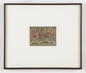
Sold2023Tony Fitzpatrick (American, b. 1958) "The China Sea Horse," 1994Tony Fitzpatrick (American, b. 1958) "The China Sea Horse," 1994, 4 color etching, signed with initials, dated, titled and P.P. Framed. Fleisher Ollman Gallery, Philadelphia, PA. Size: 15'' x 18'', 38See Sold Price
Sold2018(2) Two Anna Weatherley Fine China Group(2) Two Anna Weatherley China Group. Vase. Cookie Jar. Both appear to be used. Vase Measures 10 inches high. Cookie Jar Measures 7 inches high. Butterflies, Flowers.See Sold Price
2 days LeftJasper52South west Pacific Ocean Melanesia Polynesia ADMIRALTY sea chart 1875 (1968) map$120
2 days LeftJasper52Caroline Islands Palau Malakal Ngulu Angaur. ADMIRALTY sea chart 1928 (1956) map$120
Featured2 days LeftJasper52Fiji - Samoa Melanesia Polynesia Pacific ADMIRALTY sea chart 1896 (1954) map$140
5 days LeftBaker's Antiques and AuctionsPair of Lefton China sea captain wall plaques on a wood base$65
Featured2 days LeftJasper52Marshall Islands North Pacific Ocean Micronesia ADMIRALTY chart 1891 (1953) map$120
2 days LeftJasper52Hawaiian–Emperor seamount chain Midway-Kauai ADMIRALTY chart 1950 (1955) map$140(1 bid)
Jun 30Tremont AuctionsJade group. China. 19th century. Pair of geese and water plants. Stone with pronounced red veining.$100
4 days LeftCastle Valley Art Gallery Inc. A group, china Tang Dynasty jade Hu people music figurines$200
4 days LeftCastle Valley Art Gallery Inc. A group, china celadon twelve zodiac seated figures from Song Dynasty$500
4 days LeftCastle Valley Art Gallery Inc. A group of China Tang Dynasty painted pottery fat girl music figurines$500


![Mount & Page: Antique Coast Profile of Ireland, 1749: Title/Content of Map: '[A description of the sea coast of Ireland]' The following places are shown or referred to on the coastal profile chart: Galloway (Galway) Aran Islands Limerick Date Printed: 17](https://p1.liveauctioneers.com/5584/110608/56777156_1_x.jpg?height=310&quality=70&version=1507840413)


![It Came from Beneath the Sea. Group of Eight Color Lobby Ca...: It Came from Beneath the Sea. Group of Eight Color Lobby Cards. [Hollywood: Columbia Pictures Corp, 1955]. Cards for the classic monster movie feature the giant monster as well as cast members Kenneth](https://p1.liveauctioneers.com/928/321037/172574108_1_x.jpg?height=310&quality=70&version=1709226402)