Sold20182 Colton Civil War Maps, Military Stations & Forts, 3Two (2) Colton Civil War maps, 3 items total. 1st item: J.H. Colton, Civil War era map of the United States showing Military Stations and Forts, prepared for The Rebellion Record, New York: G.P. PutnaSee Sold Price
Sold2019Colton's Civil War map of the United States 1862Heading: (Maps) Author: Colton, J.H. Title: Colton's United States Showing the Military Stations, Forts &c. Place Published: New York Publisher: Date Published: 1862 Description:See Sold Price
Sold2017Ettling: Map of United States of North America, 1860United States of North America (Eastern & Central) T. J. Ettling, c1860 17 x 25. This great Civil War era map covers the country from the Rocky Mountains to the Atlantic seaboard. The map is engravedSee Sold Price
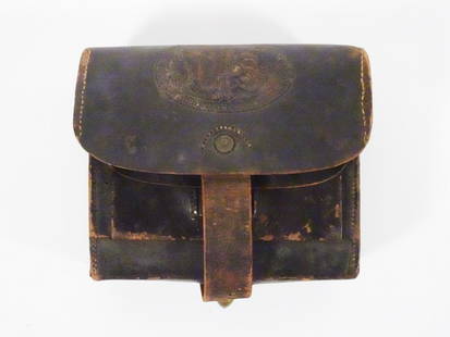
Sold2023U.S. Civil War Leather Cartridge BoxOriginal United States Civil War era Model 1864 leather cartridge box, stamped "Col. Mann's Patent Re Issued June 7th 1864. / E. Gaylord Maker Chicopee. Mass." and "J. Shepard US", 5 1/2" (h) x 6 1/4"See Sold Price
Sold20211861 Colton United States Map with Civil War MilitaryTitle: 1861 Colton United States Map with Civil War Military Stations -- Colton's United States Shewing the Military Stations Forts &c. Cartographer: J Colton Year / Place: 1861, New York Map DimensioSee Sold Price
Sold2022AN AMERICAN CIVIL WAR ERA MAP, "United States of North America (Eastern & Central)," LONDON,AN AMERICAN CIVIL WAR ERA MAP, "United States of North America (Eastern & Central)," LONDON, 1861-1873, THEODORE ETTLING (b. 1823), hand colored lithograph on paper, by T. Ettling, published by CasselSee Sold Price
Sold2022Map of United States, JH Colton, ca 1849A framed map of the United States, Map of the United States of America, The British Provinces, Mexico, the West Indies and Central America with part of New Granada and Venezuela by JH Colton, ca 1849,See Sold Price
Sold2017Civil War Era Map of the United StatesUnited States. Taliaferro Preston Shaffner (1811 – 1881). Lithographed Map. London: Schaffner, 1862. 12 1/4 x 18 1/2 inchesSee Sold Price
Sold2017Civil War Era Map of the United StatesMap of the United States and Territories. Henry F. Walling (1825 - 1889) & Ormando W. Gray (fl. 1860 – 1880). Lithographed Map. Boston, 1871. 17 x 25 1/2 inches sheetSee Sold Price
Sold2021CIVIL WAR-ERA JOHNSON'S MILITARY MAP UNITED STATESFramed engraving with color on paper, "Johnson's New Military Map of the United States, Showing the Forts, Military Posts & c., with Enlarged Plans of Southern Harbors from Authentic Data Obtained atSee Sold Price
Sold20221893 Government Map of Civil War Era United States -- Map of the United States of America ShowingTitle: 1893 Government Map of Civil War Era United States -- Map of the United States of America Showing the Boundaries of the Union and Confederate Geographical Divisions and Departments CartographerSee Sold Price
Sold20221893 Government Map of Civil War Era United States -- Map of the United States of America ShowingTitle: 1893 Government Map of Civil War Era United States -- Map of the United States of America Showing the Boundaries of the Union and Confederate Geographical Divisions and Departments; Plate CLXIVSee Sold Price
Sold20221893 Government Map of Civil War Era United States -- Map of the United States of America ShowingTitle: 1893 Government Map of Civil War Era United States -- Map of the United States of America Showing the Boundaries of the Union and Confederate Geographical Divisions and Departments; Plate CLXIISee Sold Price
Sold20221864 Civil War MAP United States Statistics Commerce1864 Civil War MAP United States Statistics Commerce American Trade Gold Silver The United States Department of Treasury published this Civil War-era report analyzing the commerce of the US GovernmentSee Sold Price
Sold2022Significant United States map, 1864 Johnson & WardVery interesting hand-colored map created at a pivotal time in the settlement of the American West. In this lovely Civil War era map many of the western states have still not settled their borders. ArSee Sold Price
Sold2017J. H. Colton: Map of United States of America, 1855The United States of America. J. H. Colton, 1855. 15.75 x 26. From the 1856 second edition of Colton’s Atlas of the World. Clean with very minor edge toning. Couple of tiny margin spots. One extremeSee Sold Price
Sold2019United States. Civil war era military map. ShowingTitle/Content of Map: United States. Civil war era military map. Showing southern ports Date: 1863 Cartographer: By Johnson & Ward. From, Johnson’s New Illustrated Family Atlas Size: 18x 26 1/4”.See Sold Price
Sold2023Civil War era map of North America from S. A. Mitchell Jr.Wonderful map of the North American continent with 1860 date but published in the 1863 Mitchell New General Atlas. Shows the United States at the height of the Civil War. Depicts the North American coSee Sold Price
Sold2017Colton: Antique Map of United States of America, 1864Map: Colton's United States of America. Unusual Idaho Includes Colored, Un-named Montana and Wyoming - Rare Publication Date: 1864 Authors: J.H. COLTON, COLTON, JOSEPH HUTCHINS Publisher: J.H. COLTONSee Sold Price
Sold20181864 Johnson Map of the United States -- Johnson'sTitle/Content of Map: 1864 Johnson Map of the United States -- Johnson's United States Date: 1864, New York Cartographer: A Johnson Size: 16.9 x 23.1 in. This is a large, highly detailed Civil War eraSee Sold Price
Sold20241865 United States Map by ColtonTitle: 1865 United States Map by Colton Date/Period: 1865 Materials: Hand colored steel engraved Size: 12 x 9" The United States, with Mexico and the Caribbean, 1865 By J. H. Colton. New York. Hand-coSee Sold Price
Sold2019J.H. Colton Map of the United States of America, c 1849J.H. Colton Map of the United States of America, c 1849. 1st edition wall version drawn by George W. Colton and engraved by John M. Atwood with the grapevine border design with small vignettes done anSee Sold Price
Sold2018JH COLTON 1854 MAP OF THE UNITED STATESD. McLellen, New York. color lithograph. 16 x 26 inches.See Sold Price
Sold2020Early United States Roll-Up MapEarly United States roll-up map. Published by J. H. Colton / New York / 1853. 44 1/2" x 36".See Sold Price
May 09Weatherham Estate TreasuresAbraham Lincoln Bronze Bust Sculpture On Marble Base - Signed Original - 10lbs$400
7 days LeftThe Written Word AutographsGardner,Alexander Civil War Photographer Very RARE Signed Check$1,500
2024Matthew Bullock AuctioneersAlbert Taylor Bledsoe, Confederate Colonel, Acting Assistant Secretary of War,Confederate States ofSee Sold Price
May 15University ArchivesLincoln Brady Photo Study for Carpenter's "First Reading of the Emancipation Proclamation," Meserve $100(1 bid)
1 day LeftCR Sails NJ Consignment & AuctionAbraham Lincoln Signed Military Discharge, September 10, 1864$800(2 bids)
578 Lots AwayBazaar of PersiaUS Half dollar 1922 100th anniversary Birth of Ulysses S. Grant Silver coin$30(3 bids)
May 12Schilb Antiquarian Rare Books1868 Civil War General Ulysses S Grant 1ed Life Army American President Deming$10(3 bids)
5 days LeftWeatherham Estate TreasuresAbraham Lincoln Bronze Bust Sculpture On Marble Base - Signed Original - 10lbs$400
May 14Fleischer's AuctionsLincoln's Funeral Cortège Book by Custodian of Lincoln's Tomb$150(2 bids)


![[RE LEE] Signed Photograph & Letter To Namesake (1 of 3)](https://p1.liveauctioneers.com/7226/325455/175169169_1_x.jpg?height=282&quality=70&version=1712370394)
![[LINCOLN] Currier & Ives "Freedom to the Slaves" Lithograph (1 of 1)](https://p1.liveauctioneers.com/7226/322253/173251614_1_x.jpg?height=282&quality=70&version=1710004847)

![[CIVIL WAR] Beardless Lincoln Cover w/ 6th Ohio Cavalry Letter (1 of 3)](https://p1.liveauctioneers.com/7226/322253/173251606_1_x.jpg?height=282&quality=70&version=1710004847)


