Sold2020CIVIL WAR USA showing Union Confederate & BorderTITLE/CONTENT OF MAP: 'United States of North America (Eastern & central)' The map depicts the United States as divided in the early part of the Civil War between the Union states, the Confederate staSee Sold Price
Sold2017Old Map of 1864 United States with Civil War BoundariesOld Map entitled "Map of the United States of America Showing Boundries of the Union & Confederate Geographic Divisions and Departments Dec. 31, 1864." Printed by Julius Bien & Co. Lith, NY. Top markeSee Sold Price
Sold20221893 Government Map of Civil War Era United States -- Map of the United States of America ShowingTitle: 1893 Government Map of Civil War Era United States -- Map of the United States of America Showing the Boundaries of the Union and Confederate Geographical Divisions and Departments CartographerSee Sold Price
Sold20221893 Government Map of Civil War Era United States -- Map of the United States of America ShowingTitle: 1893 Government Map of Civil War Era United States -- Map of the United States of America Showing the Boundaries of the Union and Confederate Geographical Divisions and Departments; Plate CLXIVSee Sold Price
Sold20221893 Government Map of Civil War Era United States -- Map of the United States of America ShowingTitle: 1893 Government Map of Civil War Era United States -- Map of the United States of America Showing the Boundaries of the Union and Confederate Geographical Divisions and Departments; Plate CLXIISee Sold Price
Sold2020Britains #2070 Union and Confederate 186329 Pieces Condition Very Good (Missing 1 Cannon) Box Very GoodSee Sold Price
Sold2017Bien: Antique Map of the US, Union & Confederate, 1895Item: Map of the United States of America showing the boundaries of the Union and Confederate geographical divisions and departments, Dec. 31, 1860 Maker: Julius Bien & Co Size: 28 x 17 inches Date: 1See Sold Price
Sold2022MapMap "MAPE / OF THE / UNITED STATES / OF AMERICA / SHOWING THE / BOUNDARIES / OF THE / UNION AND CONFEDERATE / GEOGRAPHICAL DIVISIONS / AND / DEPARTMENTS / JUNE 30 1861". Sight 17" x 28 1/2", overall 2See Sold Price
Sold2022JOHN TALLIS (1817-1876) AN AMERICAN CIVIL WAR MAP, "United States," LONDON, CIRCA 1863,JOHN TALLIS (1817-1876) AN AMERICAN CIVIL WAR MAP, "United States," LONDON, CIRCA 1863, hand-colored lithograph on wove paper showing, "Federal, Non Slave Holding States (Red); Border, Slaveholding (BSee Sold Price
Sold2021Britains American Civil War SetsUnion Colour Bearer with Flag #17525, and Confederate State Flagbearer #17867. 2 pieces. Mint condition. Boxes excellent.See Sold Price
Sold2017W Britain Set #17833 & #17867 Valley SeriesIncludes Set #17833 Union Infantry in Frock Coats Charging Set #2 and Set #17867 Confederate State Flagbearer #1 - Virginia. 54mm Figures. 4 pieces. Condition figures near mint. Condition boxes excellSee Sold Price
Sold2021Conte Civil War Gettysburg High Water Mark.Boxed Conte Products depiction of Confederates breaching the salient of the Union line on Cemetery Ridge at Gettysburg on July 3, 1863. 9 pieces, marvelous action sculpting. Condition Mint in mint boxSee Sold Price
Sold2017The Position of Yorktown and the ApproachesWashington Government Printing Office 1892. Civil War Map showing Union and Confederate troop locations and movement Size: 29 x 18 inches No Reserve: This lot starts at $1 and has no reserve as a courSee Sold Price
Sold20211863 Old Franklin Almanac CIVL WAR Confederate Union1863 Old Franklin Almanac CIVL WAR Confederate Union ARMY Troops Abe Lincoln Known as one of the most important and prolific founding fathers of America, Benjamin Franklin wrote several works that havSee Sold Price
Sold2016Civil War Map of Secessionville, James IslandTitle: Map of the Engagement At Secessionville James Island, S.C. June 16, 1862 Maker: Washington Government Printing Office Date:1892 Civil War Map showing Union and Confederate troop locations and mSee Sold Price
Sold2019Civil War Atlas, United States Boundaries Showing UnionCivil War Atlas, United States Boundaries Showing Union and Confederate Divisiomns and Departtments," 1861, Plate 164, , H. - 18 1/4 in., W. - 29 1/2 in.See Sold Price
Sold2021Civil War Geographical Boundary mapDefinitive map of the geographical boundaries between the Union and Confederate armies. Opens a window into the state of the U. S. during the height of the Civil War. “Map of the United States oSee Sold Price
Sold2016Chancellorsville Campaign and DranesvilleMap: Chancellorsville Campaign and Dranesville, Atlas to Accompany the Official Records of the Union and Confederate Armies Maker: The United States War Department Printer: Julius Bien & Company, WashSee Sold Price
Sold20201866 CIVIL WAR CONFEDERATE UNION ARMIES GETTYSBURG1866 CIVIL WAR CONFEDERATE UNION ARMIES GETTYSBURG, ILLUSTRATED 2 VOLUME SET 153 YEAR OLD HISTORY OF THE CIVIL WAR WITH DOZENS OF ILSee Sold Price
Sold2024Official Civil War Geographical Boundary map, Julius Bien 1891Scarce definitive map of the geographical boundaries between the Union and Confederate armies. Opens a window into the state of the U. S. during the height of the Civil War. “Map of the United SSee Sold Price
Sold2017Civil War Map of America June 30, 1861Framed Civil War Map of America from June 30, 1861 showing the boundaries of the Union and Confederate Geographical Divisions and Departments. It also features a gold plaque with the description. ThisSee Sold Price
Sold2021U. S. TERRITORY STILL UNDER INSURRECTIONARY CONTROLCivil War Dated Wood Engraved Map MAP SHOWING THE EXTENT OF UNITED STATES TERRITORY STILL UNDER INSURRECTIONARY CONTROL, Harper's Weekly, June 28, 1862 (Civil War, Confederate States, Rebels, SuccessiSee Sold Price
Sold2018Britains Set #2070 Civil War 2 Tier Display SetIconic American Civil War 2 tier Display Set comprising complete Cavalry, Infantry & Artillery for both Union & Confederate Forces. Classic set circa 1959 30 pieces. Condition mint with complaint slipSee Sold Price
Sold2023Britains #2070 American Civil War Display SetUnion & Confederate Troops and Guns. Post war issue. Two level boxed set. 30 pieces. Mint to near mint condition. Box excellent.See Sold Price
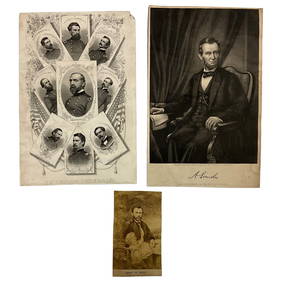
2 days LeftLakeshore Event CenterEphemera, Civil War Generals, Abraham Lincoln, Ulysses Grant, Lot of 3$62(2 bids)
3 days LeftSchilb Antiquarian Rare Books1890 1ed Confederate Memoirs of Joseph Johnston & Jefferson Davis Civil War CSA$66(3 bids)
Jul 07Case Antiques, Inc. Auctions & Appraisals3 Civil War Era Photos, incl. Rose O'Neal Greenhow, poss. Jeff Davis$150
Featured6 days LeftUniversity ArchivesCapture of Jefferson Davis: “Mr. Davis tried to escape…with a ladies waterproof$1,600
Jul 14Schilb Antiquarian Rare Books1928 Life of Abraham Lincoln 1ed SLAVERY Civil War Albert Beveridge 2v SET$1(1 bid)
Jul 04Weatherham Estate TreasuresAbraham Lincoln Bronze Bust Sculpture On Marble Base - Signed Original - 10lbs$400
Jul 06Case Antiques, Inc. Auctions & Appraisals7 Stephens and Davis CSA Items inc. ALS, Bust, CDVs and Seals$150(1 bid)
3 days LeftSchilb Antiquarian Rare Books1918 Robert E Lee Civil WAR Confederate General CSA Battles MAPS Illustrated$62(6 bids)
2 days LeftActivity AuctionsJefferson Davis Autograph Signed Civil War Confederate President Framed (JSA LOA)$1,400
BonhamsDITTERLINE, THEODORE. 1816-1883. Sketches of the Battles of Gettysburg with Explanatory Map. New...$1,600
Freeman's | Hindman[CIVIL WAR]. 13 CDVs & tintypes of Naval subjects, incl. CSS Alabama, Union officers, & sailors.$150
Freeman's | Hindman[CIVIL WAR]. Extensive research library from the Estate of Carroll J. Delery III.$100
Featured6 days LeftUniversity ArchivesAbraham Lincoln PSA GEM MT 10 CDV, Signed 3 Weeks Before His Death.$30,000(1 bid)
Featured5 days LeftJasper521876 Bachelder View of Pickett's Charge at Gettysburg -- Battle of Gettysburg (Repulse of$480
5 days LeftBonhamsCIVIL WAR. MOORE, SAMUEL PRESTON. 1813-1889. A Manual of Military Surgery Prepared for Use of th...$800(2 bids)


![[CIVIL WAR]. 13 CDVs & tintypes of Naval subjects, incl. CSS Alabama, Union officers, & sailors. (1 of 6)](https://p1.liveauctioneers.com/197/333931/180433342_1_x.jpg?height=282&quality=70&version=1718838007)
![[CIVIL WAR]. Extensive research library from the Estate of Carroll J. Delery III. (1 of 0)](https://p1.liveauctioneers.com/dist/images/placeholder.jpg?height=282&quality=70)


