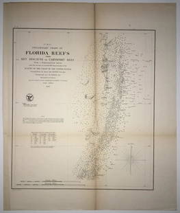
Sold2020(F No.4) Preliminary Chart of Florida Reefs from KeyTitle/Content of Map: (F No.4) Preliminary Chart of Florida Reefs from Key Biscayne to Carysfort Reef... Publication Date: 1855 Cartographer: Totten, Jas./I. Hull Adams Publisher: U.S. Coast Survey DeSee Sold Price
Sold2017Bellin: Antique Map, Florida Coastal Chart, 1764Map: Carte de la Coste de la Floride Cartographer: Bellin Place & Date: Paris / 1764 Size: 13 1/4" x 8 3/4" Condition: outline color; very light age toning at outer edges of margins A beautifully presSee Sold Price
Sold2022(FLORIDA PANHANDLE.) Joseph Frederick Wallet des Barres. The North East Shore of the Gulph of(FLORIDA PANHANDLE.) Joseph Frederick Wallet des Barres. The North East Shore of the Gulph of Mexico. Large engraved coastal chart of western Florida from Apalachicola to Mobile Bay. 4 sheets of "LVG"See Sold Price
Sold2020United States – Florida Reefs British Admiralty ChartSmall scale and detailed sea chart of the Florida Reefs with Key West and the former rail road over the islands. Tidal information is mentioned for the most important ports. Authentic, very detailed sSee Sold Price
Sold2021Vintage Intracoastal and Inland Waterway ChartsGroup of vintage intra-coastal waterway and inland waterway charts of Florida, North Carolina, Chesapeake Bay, Cuba, etc. Some staining. Provenance: The Waldingfield collection of Arthur Finkelstein aSee Sold Price
Sold2023ANTIQUE FLORIDA FRAMED MAPS - LOT OF 2148268 ANTIQUE FLORIDA FRAMED MAPS - LOT OF 2 Antique Florida map framed map to include one 1853 U.S. Coast Survey Chart or Map of St. George's Sound, Florida, and one unsigned map of Florida denotedSee Sold Price
Sold20161800's Chart Showing Penobscot Bay, MaineOriginal coastal survey from 1880 detailing Penobscot Bay from Belfast to Thomaston and as far east as Deer Isle. Mounted in a silver frame. Top of chart has minor loss. Overall Dimensions: 48" H x 40See Sold Price
Sold2022Martha’s Vineyard, 1855 Coastal SurveyPainstakingly hand-colored large chart showing Martha’s Vineyard and the Falmouth area of Cape Cod. Minutely detailed with hundreds of soundings shown. “Preliminary Chart of Muskeget ChannSee Sold Price
Sold2018Antique 1856 US Coastal Survey of Martha's VineyardTitle/Content of Map: 1856 US Coastal Survey of Martha's Vineyard amd Nantucket Area in Massachusetts -- Preliminary Chart of Part of the Sea Coast of Massachusetts from Saughkonnet River to PlymouthSee Sold Price
Sold2019A.D. Bache U.S. Coast Survey Charts East CoastA.D. Bache: Preliminary Coastal Chart N. 8, Sequin Island to Kennebunkport, Maine 1859. Measures 38” X 22”. Paper size 40" x 24 1/2". Used Condition, creases, burn. electrotype have some sSee Sold Price
Sold2023SPI BRONZE RIBBON REEF DOLPHINS SCULPTURE 9"SPI SAN PACIFIC BRONZE SEA TURTLE DUET SCULPTURE STATUE | FLORIDA COASTAL HOME DECOR ANIMAL LOVER SEA LIFE PATINATED VERTIGRIS-8" X 9" X 4" APPROX -VERY GOOD CONDITION-DP111723WINDO Bidders may pick uSee Sold Price
Sold2023DOC Map, Fowey Rocks to Alligator Reef, Florida East CoastA color map depicting the land and sea area of Fowey Rocks to Alligator Reef. Publishing stamp by "The U.S Coast and Geodetic Survey" located on bottom. Issued: 1921 Dimensions: 46"L x 35"W MaSee Sold Price
Sold2020United States, East Coast – Forida Street BritishUnused, very detailed sea chart of the Florida coasts with Miami, Cape Kennedy, the Bahama Banks and so on. The first surveys are from 1898 from Admiralty surveys. Authentic, very detailed sea chart,See Sold Price
Sold2018Scarce Sea Chart with every building, fort andHarrison, A. M. & Dorr, F. W. et al. Coast Chart No. 59, St. Augustine Inlet to Halifax River Florida. Lithographed map. U.S. Coast and Geodetic Survey, c. 1885. 41 ¼" x 31 ⅛" sheet. Great dSee Sold Price
Sold2019Western Coast of U. S., 1854 Coast SurveyLarge, impressive nautical chart of the Reconnaisance of the Western Coast of the United States (Middle Sheet) from San Francisco to Umpquah River. Coastal chart of the western coast with twelve vigneSee Sold Price
Sold2019Western Coast of U. S., 1853 Coast SurveyHand-colored, antique nautical chart of the Western Coast of the United States, from Gray’s Harbor to the Entrance of Admiralty Inlet. Coastal chart of the northwestern corner of Washington, Cape FlSee Sold Price
Sold2017USCGS: Antique Coastal Chart Map of Suisun Bay, 1870Title/Content of Map: 'Suisunbay California from a Trigonometrical survey under the direction of A.D. Bache, Superintendent of the survey of the Coast of the United States Published by 1872' COASTAL CSee Sold Price
Sold2023U S Coast Survey 1856 Large Map. St. Mary's Bar & Fernandina Harbor Florida"Preliminary Chart of St. Mary's Bar and Fernandina Harbor Florida"Large Lithograph Map Published 1857, Washington for "U.S. Coast and Geodetic Survey" Folds as issued. Paper Size: 25 x 23 inch (64 xSee Sold Price
Sold2022The Atlantic Coast Pilot (1878)A copy of The Atlantic Coast Pilot. Boston Bay to New York. By the United States Coast Survey. (Washington, D.C., 1878). With many engraved folding plates of coastal profiles and harbor charts.See Sold Price
Sold2021Kerry Hallam Acrylic on Coastal Chart - Long IslandKerry Hallam (British 1937-2020) Acrylic on Coastal Chart - Long Island Sound, Nantucket Sound and New England Coastline, signed lower left 26 in. x 43.5 in. Overall 29.5 in. x 47.5 in. Dimensions 26See Sold Price
Sold20151845 U.S. Coastal Survey Print NY Bay and HarborU.S. Coastal Survey Print, Map of New York Bay and Harbor and the Environs, published 1845, A.D. Bache Superintendent, overall 30-1/2 x 38-1/2""See Sold Price
Sold2024COASTAL FLORIDA EGRETS PAINTING 39.5"COASTAL FLORIDA EGRETS PAINTING-27" X 39.5" APPROX-VERY GOOD PRE OWNED CONDITION-DP31124 Bidders may pick up their items from the auction-house or have their items shipped.Appointments are required foSee Sold Price
2022M. HENDERSON COASTAL FLORIDA WATERCOLOR TRIPTYCHORIGINAL MAULINE HENDERSON COASTAL FLORIDA BIRD WATERCOLOR PAINTING TRIPTYCH WALL ART 28" X 40.5" EACH-VERY GOOD CONDITION, SEE PHOTOS-DP5322See Sold Price
Sold2021Dezene, Signed Coastal Florida PaintingDezene, Signed Coastal Florida Painting depicting pal trees being tossed byu the wind, sailboat in the distance. Oil on board. Signed lower right, inscribed verso. Sight Size: 20 x 16 in. Overall FramSee Sold Price
Jun 13Swann Auction Galleries(HAWAII.) Group of 8 eighteenth-century engraved maps and coastal elevation charts.$1,300
Jun 11Bill Hood & Sons Art & Antique AuctionsPossibly Giacinto Gigante (Italian 1806-1876) Coastal Scene by Moonlight, Watercolor, Signed, Image$250
Jun 11Bill Hood & Sons Art & Antique AuctionsCECIL SCHAPIRO, (NYC, 20th Century), Watercolor on Paper, MODERNIST AMERICAN SCENE COASTAL$100
2 days LeftRapid Estate Liquidators and Auction Gallery1910 USGS Topographic Map of Iowa-Illinois$5(1 bid)


![Columbus Audubon Society Calendars [180983] (1 of 7)](https://p1.liveauctioneers.com/2699/331499/178846655_1_x.jpg?height=282&quality=70&version=1717095214)
