Sold2017Edward Wells, map North AmericaEdward Wells, map North America, Edward Wells (British, 1667-1727), "A New Map of North America Shewing its Principal Divisions, Chief Cities, Townes... Dedicated to His Highness William Duke of GloucSee Sold Price
Sold2018EDWARD WELLS (ENGLISH, 1667-1727) MAP OF NORTH AMERICAEDWARD WELLS (ENGLISH, 1667-1727) MAP OF NORTH AMERICA, hand-colored, on laid paper, cartouche in upper left corner lettered in part "A New Map of NORTH AMERICA / Shewing its Principal Divisions, ChieSee Sold Price
Sold2023Group of MapsMAPS. - [Edward WELLS]. A New Map of the Most Considerable Plantations of the English in North America. [Oxford: c. 1700]. Engraved map, hand-colored in outline. Wide margins (sheet size: 17.5 x 22.25See Sold Price
Sold20222 maps, colonial New York & North America, New York2 maps, colonial New York & North America, New York City, North River, Hudson Valley, "for D1, Valentine's Manual, for 1860, 13' by 10" & map of North America, United States, with various illustrationSee Sold Price
Sold2020KITCHIN, THOMAS. A New Map of the British Empire inKITCHIN, THOMAS. A New Map of the British Empire in Nth. America. Hand-colored engraved folding map of colonial North America from George Millar's New and Universal System of Geography. 13½x15See Sold Price
Sold2022(COLONIAL NORTH AMERICA.) Group of 3 small format 18th-century engraved maps.(COLONIAL NORTH AMERICA.) Group of 3 small format 18th-century engraved maps. London, vd - The Royal Magazine; G. Rollos, engraver. A New and Accurate Map of the Present Seat of War in North America.See Sold Price
Sold2020MOLL, HERMAN. A Map of New France Containing Canada,MOLL, HERMAN. A Map of New France Containing Canada, Louisiana &c. in Nth America. Hand-colored engraved map of colonial North America. 7¾x10¾ inches sheet size, ample margins; mounted to foSee Sold Price
Sold2022(CARIBBEAN.) Emanuel Bowen. A New and Accurate Chart of the West Indies with the Adjacent Coasts of(CARIBBEAN.) Emanuel Bowen. A New and Accurate Chart of the West Indies with the Adjacent Coasts of North and South America. Double-page engraved map of colonial North America and the western AtlanticSee Sold Price
Sold2019Stanford Map of North AmericaSTANFORD, Edward (1827-1904). North America (Sheet II) The dominion of Canada, parts of Quebec and New Brunswick... Lithograph with original hand color from the Society for the Diffusion of Useful KnoSee Sold Price
Sold2022Antique Map - Map of North America - Michigan - Wisconsin - Detroit - Oliver J.Original antique map of Michigan & Wisconsin from Francis McNally's System of Geography: National Geographical Series, (New York: S. Barnes & Co., c. 1871), drawn by J. Wells NY. Technique: Steel EngrSee Sold Price
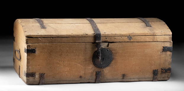
Sold202218th C. Spanish Colonial Mexican Wood & Iron TrunkNorth America, probably Mexico or New Mexico, Spanish Colonial period, ca. late 18th to early 19th century CE. This is a large and well-preserved storage or travel trunk made from wood and wrought iroSee Sold Price
Sold2024John Cary 1819 Map of North AmericaJohn Cary 1819 Map of North America. 'A New Map of North America from the Latest Authorities' by John Cary, Engraver 1819. Overall Size: 25 x 26 1/2 in. Sight Size: 18 1/2 x 21 in. #1430See Sold Price
Sold2016[Map] New Map North America 1855Jacob Monk ,Baltimore; North America and Territories, Canada,Central America and West Indies, 57 x 62 in. Large Roll down map.See Sold Price
Sold2023 [MAPS - COLONIAL NORTH AMERICA]. VAUGONDY, Gilles Robert de...[MAPS - COLONIAL NORTH AMERICA]. VAUGONDY, Gilles Robert de (1688-1766). Partie de l'Amerique Septentrionale qui Compred le Cours de l'Ohio… Paris, 1755. Large hand-colored engraved map (520 x 6See Sold Price
Sold2016Early Map: "A New Map Of North America...."Early map: "A New Map Of North America Showing its Principal Divisions....Dedicated To His Highness William Duke Of Gloucester...". Dated 1573. Sight 15" x 19 1/2".See Sold Price
Sold2022(COLONIAL NORTH AMERICA.) Richard William Seale. A Map of North America with the European(COLONIAL NORTH AMERICA.) Richard William Seale. A Map of North America with the European Settlements & Whatever Else is Remarkable in ye West Indies. Double-page engraved map of North America featuriSee Sold Price
Sold2016A NEW MAP OF NORTH AMERICA FROM 1763 DISCOVERIESPrinted on laid paper with Irish 1763 Pro Patria watermark of Detailed map of the British Colonies in North America at the close of the French & Indian War. The claims of the Carolinas, Virginia and NSee Sold Price
Sold2021"A New Map of North America" by John Cary, 1806John Cary (English, 1754-1835). An engraved map with hand coloring by famed cartographer John Cary, whose maps of North America documented the wide ranging unknown, especially surrounding the MidwestSee Sold Price
Sold2019Thomas Conder (1747-1831), "A New Map of North AmericaThomas Conder (1747-1831), "A New Map of North America Agreeable to the Most Approved Maps and Charts," H. - 14 in., W. - 18 in.See Sold Price
Sold20181785 A New Map of North AmericaA New Map of North America, published for Harrison and Co., 1785, London. Folding map, light offset, Fine condition, measures 15.5 x 10". Please note that this lot has a confidential reserve. When youSee Sold Price
Sold2019Unknown, "A New Map of North America," mounted andUnknown, "A New Map of North America," mounted and matted, H. - 10 in., W. - 10 1/2 in.See Sold Price
Sold2024Pownall Map of North America with the West India IslandsPOWNALL, Thomas (1720-1805). A New Map of North America with the West India Islands, divided according to the Preliminary Articles of Peace, Signed at Versailles, 20, jan 1783, wherein are particularlSee Sold Price
Sold2024Lotter Map Of Colonial North America In French By Matthew AlbertMap is roughly 1760's, Site 24.5" x 20.25"See Sold Price
Sold2022(AMERICAN SOUTHEAST.) Herman Moll. Carolina.(AMERICAN SOUTHEAST.) Herman Moll. Carolina. Engraved map of colonial North America from St. Augustine to the Chesapeake Bay. 8½x12 inches sheet size, ample margins; minor closure at upper edge,See Sold Price
3 days LeftJasper52New Map of That Portion of North America Exhibiting the United States and Territories...Mexico...$360
4 days LeftDoyle New YorkA highly detailed map of New England after the Jansson-Visscher series$200(1 bid)
4 days LeftDoyle New YorkThe top sheet of the famous Ratzer Map - with additions relating to an 1810 real estate dispute$7,500
Featured4 days LeftJasper52New Zealand Sandwich Galapagos Islands. Papuan Archipelago. Melanesia 1860 map$130
May 15University ArchivesDeclaration of Independence, Very Early British Publ. in Gentleman's Magazine & Rare Map$1,000
4 days LeftDoyle New YorkThe Audubon's definitive study of American four-footed wildlife$2,000(1 bid)


![Group of Maps: MAPS. - [Edward WELLS]. A New Map of the Most Considerable Plantations of the English in North America. [Oxford: c. 1700]. Engraved map, hand-colored in outline. Wide margins (sheet size: 17.5 x 22.25](https://p1.liveauctioneers.com/3975/301526/160694339_1_x.jpg?height=310&quality=70&version=1694182765)


![[Map] New Map North America 1855: Jacob Monk ,Baltimore; North America and Territories, Canada,Central America and West Indies, 57 x 62 in. Large Roll down map.](https://p1.liveauctioneers.com/523/85328/43939935_1_x.jpg?height=310&quality=70&version=1455914464)
![[MAPS - COLONIAL NORTH AMERICA]. VAUGONDY, Gilles Robert de...: [MAPS - COLONIAL NORTH AMERICA]. VAUGONDY, Gilles Robert de (1688-1766). Partie de l'Amerique Septentrionale qui Compred le Cours de l'Ohio… Paris, 1755. Large hand-colored engraved map (520 x 6](https://p1.liveauctioneers.com/928/301544/160920952_1_x.jpg?height=310&quality=70&version=1694462960)


