Sold2022(AMERICAN SOUTHEAST.) Herman Moll. Carolina.(AMERICAN SOUTHEAST.) Herman Moll. Carolina. Engraved map of colonial North America from St. Augustine to the Chesapeake Bay. 8½x12 inches sheet size, ample margins; minor closure at upper edge,See Sold Price
Sold2016Map of Port Royal Harbour Carolina by Herman Moll 1730Map: Plan of Port Royal Harbour in Carolina Maker: Herman Moll Date: 1730-32 Size: 8 x 10.5 inches Hilton Head and Port Royal, South Carolina. Moll notes on the map that it is "the best Country in CarSee Sold Price
Sold2023AMERICA H. Moll Geographer 1732 MapHerman Moll 1732 Map of the Americas, North and South America with California depicted as an island. Hand Colored engraving 8 1/2 x 11 in Matt.See Sold Price
Sold2023HERMAN MOLL (ENGLISH, C. 1654-1732) MAP OF NORTH AND SOUTH CAROLINAHERMAN MOLL (ENGLISH, C. 1654-1732) MAP OF NORTH AND SOUTH CAROLINA, hand-colored engraving on laid paper, titled "CAROLINA / By / H. Moll Geographer" in a rectangular cartouche along lSee Sold Price
Sold2016Carolina & Bermuda 1716Map Title: Carolina & The Island Bermudos Maker: Herman Moll Date: 1716 Origin: Atlas Geographicus Size: 13 x 16 inches Medium: Copperplate engraving Herman Moll (1654-1732) was a London cartographer,See Sold Price
Sold2022Moll, Plan of Port Royal Harbour in Carolina 1730-32Property from the Collection of John and Virginia Duncan, Savannah, GA Description: Herman Moll (1654-1732), A Plan of Port Royal Harbour in Carolina, Engraving, 1730-32, A Plan of Port Royal HarbSee Sold Price
Sold2017H. Moll: Rare Antique Map of Carolina, 1746Title/Content of Map: Carolina's Rare & important Map Date Printed: 1746 Cartographer: Thomas Salmon & Herman Moll Material/Medium: Paper Size: 14 1/2" x 8 1/2" Copperplate engraved. Published in LondSee Sold Price
Sold2022BEAVER MAP, HERMAN MOLL (DUTCH/BRITISH, 1654-1732)A New and Exact Map of the Dominions of the King of Great Britain on ye Continent of North America containing Newfoundland, New Scotland, New England, New York, New Jersey, Pensilvania, Maryland, VirgSee Sold Price
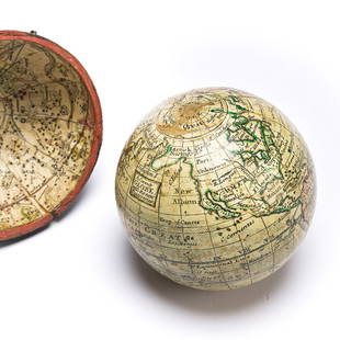
Sold2023(GLOBES.) Style of Herman Moll. A Correct Globe with the New Discoveries.(GLOBES.) Style of Herman Moll. A Correct Globe with the New Discoveries. 2¾-inch miniature terrestrial pocket globe comprised of 12 hand-colored engraved gores and 2 polar calottes on a plasterSee Sold Price
Sold2024Map of the North Parts of America Claimed by France by Herman Moll (London, 1720)Map of the North Parts of America Claimed by France by Herman Moll (London, 1720) "A New Map of the North Parts of America claimed by France under ye Names of Louisiana, Mississippi, Canada, and New FSee Sold Price
Sold2020Herman Moll Emanuel Bowen "A Complete System of GHerman Moll (ca. 1654-1732) and Emanuel Bowen (1694-1767), "A Complete System of Geography," London, 1747. Volumes I and II. The title page reads: "A Complete System of Geography. Being a DescriptionSee Sold Price
Sold2017FRAMED WORLD MAP BY HERMAN MOLL, 1719'A New & Correct Map of the Whole World, by Herman Moll, Geographer, 1719.' Hand tinted and framed. Frame size: 73 x 124 cm (28 3/4 x 48 3/4 in.)See Sold Price
Sold2019Herman Moll 1654-1732), "A New And Correct Map of theHerman Moll 1654-1732), "A New And Correct Map of the World," 1710, hand colored, H. - 22 in., W. - 38 in.See Sold Price
Sold2018Herman Moll. Atlas Minor. Lon: Bowles, 1732.[Atlas] Herman Moll. Atlas Minor. Lon: Thos. Bowles & John Bowles, (1732). Engraved title + 50 of 62 maps with hand colored outline. Lacking maps 5, 8, 9, 19, 24, 27, 31, 49, 50, 51, 52, and 58. OblonSee Sold Price
Sold2022Herman Moll's New Map of the World - California as an Island!, Ca. 1725Herman Moll's New Map of the World - California as an Island!, Ca. 1725 1p, measuring 13.625" x 8.5", n.p., ca. 1725. A hand-colored map entitled "A New Map of the World according to the New ObservatiSee Sold Price
Sold2020Herman Moll Map of Africa ca. 1720Herman Moll (ca. 1654-1732). Map of Africa, London, ca. 1720. With an elaborate dedication cartouche reading "To the right honourable Charles, Earl of Peterborow and Monmouth, etc this map of Africa aSee Sold Price
Sold20241784 Herman Moll "Bowles's Geographica Classica or the Geography of the Ancients"as contained in the greek and latin classics, exhibited in 32 maps showing the several empires, kingdoms, and provinces, the chief cities, towns, rivers and mountains mentioned in Homer, Herodotus, JuSee Sold Price
Sold2024Herman Moll A New Map of Ye North Parts of AmericaHerman Moll (British, 1654-1732). Colored engraved map, A New Map of Ye North Parts of America Claimed by France Under Ye Names of Louisiana, Mississipi [sic], Canada & New France, With the AdjoiningSee Sold Price
Sold2021American Carolina Lily quilt 71" x 81 1/2"American Carolina Lily quilt USA, first half 20th century hand-stitched cotton fabrics with appliqué 71" x 81 1/2"See Sold Price
Sold2016Straights of Magellan by Herman Moll, 1716Original copper engraving of Straights of Magellan published in Atlas Geographicus by Herman Moll, London, 1716. Dimensions: 11 1/2” x 19 1/2” Shipping Domestic: Shipping rates are determind by deSee Sold Price
Sold20231729 Map of New England, New York, Herman Moll1729 English Map of New England, Herman Moll (1654-1732). Map titled, "NEW ENGLAND NEW YORK NEW JERSEY and PENNSYLVANIA". Map with detailed depiction of the North East, with hand coloring. Good conditSee Sold Price
Sold2016America by Herman Moll 1716Map Title: America, According to the Newest and Most Exact Observations Maker: Herman Moll Date: 1716 Origin: Atlas Geographicus Size: 13 x 16 inches Medium: Copperplate engraving Herman Moll (1654-17See Sold Price
Sold2023Herman Moll, Map of Bermuda, 1729Herman Moll, Map of Bermuda, 1729, "The Island of Bermudos Divided into its Tribes, with the Castles, Forts, &c", hand-colored engraving on paper, gallery stamps verso, matted and framed under glass,See Sold Price
Sold2022(AMERICAS.) Herman Moll. A Map of America According to ye Newest and Most Exact Observations.(AMERICAS.) Herman Moll. A Map of America According to ye Newest and Most Exact Observations. Engraved map of North and South America showing California as an island. 11½x7¾ inches sheet sizSee Sold Price
2 days LeftLeland LittleJ. M. Henry (American, b. 1959), Moonrise (Theme for an Imaginary Western)$100(3 bids)
5 days LeftBKG Antique MallSigned Herman Maril (American, 1908-1986) Oil Painting on Board Training Period$800


![Herman Moll. Atlas Minor. Lon: Bowles, 1732.: [Atlas] Herman Moll. Atlas Minor. Lon: Thos. Bowles & John Bowles, (1732). Engraved title + 50 of 62 maps with hand colored outline. Lacking maps 5, 8, 9, 19, 24, 27, 31, 49, 50, 51, 52, and 58. Oblon](https://p1.liveauctioneers.com/179/122672/62428326_1_x.jpg?height=310&quality=70&version=1527272450)


![Herman Moll A New Map of Ye North Parts of America: Herman Moll (British, 1654-1732). Colored engraved map, A New Map of Ye North Parts of America Claimed by France Under Ye Names of Louisiana, Mississipi [sic], Canada & New France, With the Adjoining](https://p1.liveauctioneers.com/7691/320359/172153415_1_x.jpg?height=310&quality=70&version=1708543789)


