Sold2018Levasseur, Victor 1859 Map of Guadeloupe. Caribbean"Colonies Francaises en Amerique" Steel Engraved Map Published 1859, Paris for "Atlas National Illustre" by Victor Levasseur. Paper Size: 20.5 x 14.5 inch (52 x 37cm)See Sold Price
Sold2020Levasseur, Victor C1850 Map of Guadeloupe Caribbean"Colonies Francaises en Amerique" Steel Engraved Decorative Map Published C1850, Paris for "Atlas National Illustre" by Victor Levasseur. Paper Size: 20.5 x 15 inch (52 x 38cm) Good ConditionSee Sold Price
Sold2022Antique 1857 West Indies Map of French ColoniesAntique 1857 West Indies Map of French Colonies, original Victor Levasseur map of Colonies Francaises (En-Amerique), gorgeously illustrated map, verso reads MARINO RONCARI Frame Gallery Inc, professioSee Sold Price
Sold2020Levasseur, Victor C1850 Map of Madagascar & Gambia"Colonies Francaises en Afrique" Steel Engraved Decorative Map Published C1850, Paris for "Atlas National Illustre" by Victor Levasseur. Paper Size: 20.5 x 15 inch (52 x 38cm) Good ConditionSee Sold Price
Sold2018Levasseur, Victor 1859 Map of Senegal, Madagascar"Colonies Francaises en Afrique" Steel Engraved Map Published 1859, Paris for "Atlas National Illustre" by Victor Levasseur. Paper Size: 20.5 x 14.5 inch (52 x 37cm) Good ConditionSee Sold Price
Sold2020Levasseur, Victor 1869 Pair of HC Maps of N. & W."Algerie, Colonie Francaise" and " Colonies Francaises en Afrique" showing Senegal etc. Hand Coloured Steel Engraved Decorative Maps Published C1850, Paris for "Atlas National Illustre" by Victor LevaSee Sold Price
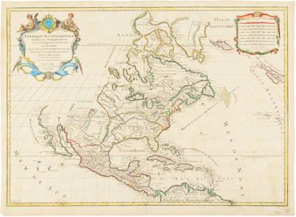
Sold2017Levasseur: Antique Map of North America, 1840Title/Content of Map: 1840 Levasseur Map of North America - Amerique Septrentionale Date Printed: 1840 Paris Cartographer: V. Levasseur Size: 11 x 16.5 in. Condition: Excellent. Minor age toning; issuSee Sold Price
Sold2023FIRST EDITION OF RARE REVOLUTIONARY WAR MAPCarte Nouvelle des Possessions Angloises en Amérique dressée pour l'intellegence de la guerre, Paris 1777, Maurille Antoine Moithey, engineer. Translation: New map of the English possessionsSee Sold Price
Sold2023Partie de l'Amerique Septentrionale… Northeastern USA. VAUGONDY 1755 old mapTITLE OF MAP (NOT PRINTED ON THE PAGE):'Partie de l'Amerique Septentrionale, qui comprend le Cours de l'Ohio, la Nlle. Angleterre, la Nlle. York, le New Jersey, la Pensylvanie, le Maryland, la VirginiSee Sold Price
Sold20191792 Elwe Map of North America -- AmeriqueTitle/Content of Map: 1792 Elwe Map of North America -- Amerique Septentrionale Divisee en Ses Principales Parties Cartographer: J ElweDate: 1792, Amsterdam Size: 18.3 X 23.1 in. This is an outstandinSee Sold Price
Sold2017GEORGE-LOUIS LE ROUGE (FRENCH, 18TH CENTURY)GEORGE-LOUIS LE ROUGE (FRENCH, 18TH CENTURY) REVOLUTIONARY WAR MAP hand-colored engraving on laid paper, "Theatre du Guerre en Amerique", published in Paris 1777, includes a small vignette of NiagaraSee Sold Price
Sold2020A LOUIS XIV MAP, "L'Amerique Septentrionale," HUBERTA LOUIS XIV MAP, "L'Amerique Septentrionale," HUBERT JAILLOT, PARIS, 1696, hand colored engraving on paper, "Divisée en ses principals parties, ou sont distingués les uns des autres Les Estats suivaSee Sold Price
Sold2017Jaillot: Antique Map of North America, 1696Map: 1696 Jaillot Map of North America (California as an Island) -- Amerique Septentrionale Divisee en ses Principales Parties Date Printed: 1696 Amsterdam Cartographer: H. Jaillot Size: 19.3 x 23 in.See Sold Price
Sold2015Map of North America 1719Heading: (North America) Author: Sanson, Nicolas/ Hubert Jaillot Title: Amerique Septentrionale divisée en ses Principales Parties, ou sont distingués les uns des autres les Estats suivant quils appSee Sold Price
Sold2016Hubert Jaillot. Amerique Septentrionale diviséeHubert Jaillot. Amerique Septentrionale divisée en ses principales parties<See Sold Price
Sold2023General Map of the West Indies'. West sheet only. Bryan EDWARDS. Caribbean 1794Title: General Map of the West Indies'. West sheet only. Bryan EDWARDS. Caribbean 1794 Description: A New Map of the West Indies for the History of the British Colonies by Bryan Edwards' by Bryan EdwaSee Sold Price
Sold2022ENGRAVED MAP OF THE AMERICAN COLONIES BY JEAN PALAIRET 1775 17.5” x 23” sight. FramedENGRAVED MAP OF THE AMERICAN COLONIES BY JEAN PALAIRET1775Double-page “Carte des Possessions Angloises & Françoises du Continent de l'Amérique". After Mitchell.17.5” x 23See Sold Price
Sold2020Early Coltons atlas of the world vol. IThis old atlas is large and measures 16.5in x 18.75in overall. The book should be rebound and does have some ware on the edges. Maps are dated 1856. There are many antique maps inside and they range iSee Sold Price
Sold2019Ca. 1856 Map titled Algerie Colonie FrancaiseCa. 1856 Atlas Map titled Algerie Colonie Francaise. Atlas National Illustre. V. Lavasseur. Measures 13.75 in. x 20.625 in. Unframed, loose and not mounted or glued down. If lot is absent of a conditiSee Sold Price
Sold20231835 DEMOCRATIE EN AMERIQUE VOL II BOOK BY TOCQUEVILLEDe la Democratie en Amerique, Democracy in America by Alexis De Tocqueville. Published by Librairie de Charles Gosselin, Paris, 1835. Vol. II of two only. In French. First edition in rare original papSee Sold Price
Sold2022Atlas. SANSON D'ABBEVILLE. L'Europe, l'Asie, L'Afrique, l'Amérique en plusieurs cartes et enSANSON D'ABBEVILLE, Nicolas. L'Europe, l'Asie, L'Afrique, l'Amérique en plusieurs cartes et en divers traités de Géographie et d'Histoire.Paris, Chez l'Autheur 1683In-4to. 220x175 mm. LSee Sold Price
Sold2020William Penn MDS Selling 500 Acres in His 1-Year-OldWilliam Penn MDS Selling 500 Acres in His 1-Year-Old Colony for Less Than a Penny an Acre! 1p manuscript document signed by Pennsylvania founder William Penn (1644-1718) along the bottom fold. [LondonSee Sold Price
Sold2017BRETON, Jules. Oil on Panel. Study for "TheBlessing of the Wheat" (La Benediction de Bles en Artois), c. 1856/1857. Jules Breton (French, 1827-1906). This is a study for one of Breton's most famous works, "La Benediction de Bles en Artois", whSee Sold Price
Sold2020Alex Katz, American (Born 1927)Alex Katz, American (Born 1927) 1979 Screenprint in Colors on Stonehenge Paper "Red Band" Pencil Signed and Numbered 2/60 Lower Left. Maravell catalog raisonne. Remnant of an old gallery label en versSee Sold Price
7 hrs LeftDuMouchellesRigobert Bonne (French, 1727-1794) Hand Colored Engraving Ca. 18th Century, Les Etats Unis De$50(1 bid)
BonhamsEGYPT - ANTIQUITIES [Description de l'Égypte, ou recueil des observations et des recherches...£400
BonhamsILLUMINATED MANUSCRIPT - NINETEENTH CENTURY The Ballad of Chevy Chase, ILLUMINATED MANUSCRIPT, '...£500(1 bid)