Sold2017Colton: Antique Map of Chicago & St. Louis, 1859Title/Content of Map: Chicago & St. Louis by Colton Date Printed: 1859 Cartographer: H. J. Colton Material/Medium: Paper Size: 17 1/2" x 15" Hand colored engraved. Published in New York in 'Colton's GSee Sold Price
Sold2017Colton: Antique Map of St. Louis & Chicago, 1861Title/Content of Map: St. Louis & Chicago Date Printed: 1861 Cartographer: J.H. Colton Material/Medium: Paper Size: 17 1/2" x 14" Hand colored, steel engraved. From 'Colton's General Atlas. PublishedSee Sold Price
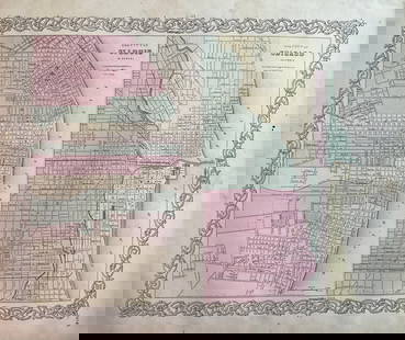
Sold20201855 Colton Map of Chicago and St. Louis -- The CityTitle/Content of Map: 1855 Colton Map of Chicago and St. Louis -- The City Map of St. Louis Missouri [with] The City Map of Chicago Illinois Date: 1855, New York Cartographer: J ColtonSize: 11.8 X 14.See Sold Price
Sold20231859. St. Louis and Chicago by ColtonTitle: 1859. St. Louis and Chicago by Colton Date/Period: 1859 Materials: Steel engraved Size: 17 1/2 x 14 1/2? St. Louis and Chicago. By J. H. Colton & G. W. Colton. From "General Atlas". Published iSee Sold Price
Sold2019Colton's St. Louis/Chicago Map [Midwest City Map]Colton's St. Louis and Chicago Map; left is St. Louis and right is Chicago. J. H. Colton Cartographer. Published by J. H. Colton, New York. Stamped 'Entered according to Act of Congress in the Year 18See Sold Price
Sold2017Lee: Antique Map of St. Louis & Mississippi River, 1837Map: 1837 Lee Map of St. Louis and Mississippi River -- No.3. Map of the Harbor of St. Louis, Mississippi River. Oct. 1837 Cartographer: R E Lee Year / Place: 1837, Washington Map Dimensions: 16 x 41See Sold Price
Sold2017Mitchell: Antique Map of St. Louis, 1869Title/Content of Map: St. Louis Date Printed: 1869 Cartographer: Augustus S. Mitchell Material/Medium: Paper Size: 15" x 12" Hand colored engraved Map. From 'Mitchell's New General Atlas.' Published iSee Sold Price
Sold2017Colton: Antique Map of Cuba, 1859Title/Content of Map: Cuba by Colton Date Printed: 1859 Cartographer: H. J. Colton Material/Medium: Paper Size: 17 1/2" x 15" Hand colored engraved. Published in New York in 'Colton's General Atlas'.See Sold Price
Sold2018Colton: Antique Map of Georgia, 1859Title/Content of Map: Georgia by Colton Date Printed: 1859 Cartographer: H.J. Colton Material/Medium: Paper Size: 17 1/2" x 15" Hand colored,engraved. Published in New York in 'Colton's General Atlas.See Sold Price
Sold2017Colton: Antique Map of Wisconsin, 1859Title/Content of Map: Wisconsin by Colton Date Printed: 1859 Cartographer: H. J. Colton Material/Medium: Paper Size: 17 1/2" x 15" Hand colored engraved. Published in New York in 'Colton's General AtlSee Sold Price
Sold2018Colton: Antique Map of London, 1859Title/Content of Map: London by Colton Date Printed: 1859 Cartographer: H.J. Colton Material/Medium: Paper Size: 17 1/2" x 15" Hand colored,engraved. Published in New York in 'Colton's General Atlas.'See Sold Price
Sold2018Colton: Antique Map of Prussia, 1859Title/Content of Map: Prussia by Colton Date Printed: 1859 Cartographer: H.J. Colton Material/Medium: Paper Size: 17 1/2" x 15" Hand colored,engraved. Published in New York in 'Colton's General Atlas.See Sold Price
Sold2018Colton: Antique Map of Vermont, 1859Title/Content of Map: Vermont by Colton Date Printed: 1859 Cartographer: H.J. Colton Material/Medium: Paper Size: 17 1/2" x 15" Hand colored,engraved. Published in New York in 'Colton's General Atlas.See Sold Price
Sold2018Colton: Antique Map of Russia, 1859Title/Content of Map: Russia by Colton Date Printed: 1859 Cartographer: H.J. Colton Material/Medium: Paper Size: 17 1/2" x 15" Hand colored,engraved. Published in New York in 'Colton's General Atlas.'See Sold Price
Sold2018Colton: Antique Map of Connecticut, 1859Title/Content of Map: Connecticut by Colton Date Printed: 1859 Cartographer: H.J. Colton Material/Medium: Paper Size: 17 1/2" x 15" Hand colored,engraved. Published in New York in 'Colton's General AtSee Sold Price
Sold2018Colton: Antique Map of Mississippi, 1859Title/Content of Map: Mississippi by Colton Date Printed: 1859 Cartographer: H. J. Colton Material/Medium: Paper Size: 14" x 17" Provenance: New York Published in New York Please note that this lot haSee Sold Price
Sold2018Colton: Antique Map of Asia, 1859Asia by Colton 1859 H.J. Colton 17 1/2" x 15" Hand colored and engraved. Published in New York in Colton's 'General Atlas'. Please note that this lot has a confidential reserve. When you leave a bid iSee Sold Price
Sold2018Colton: Antique Map of Mexico, 1859Title/Content of Map: Mexico by Colton Date Printed: 1859 Cartographer: H.J. Colton Material/Medium: Paper Size: 17 1/2" x 15" Hand colored, engraved Map. Published in New York in Colton's 'General AtSee Sold Price
Sold2017Colton: Antique Map of Louisiana, 1859Title/Content of Map: Louisiana by Colton Date Printed: 1859 Cartographer: H. J. Colton Material/Medium: Paper Size: 17 1/2" x 15" Hand colored engraved. Published in New York in 'Colton's General AtlSee Sold Price
Sold2018Colton: Antique Map of Maine, 1859Title/Content of Map: Maine by Colton Date Printed: 1859 Cartographer: H.J. Colton Material/Medium: Paper Size: 17 1/2" x 15" Hand colored,engraved. Published in New York in 'Colton's General Atlas.'See Sold Price
Sold2018Colton: Antique Map of Alabama, 1859Title/Content of Map: Alabama by Colton Date Printed: 1859 Cartographer: H.J. Colton Material/Medium: Paper Size: 17 1/1" x 15" Hand colored,engraved. Published in New York in 'Colton's General Atlas.See Sold Price
Sold2018Colton: Antique Map of Missouri, 1859Title/Content of Map: Missouri by Colton Date Printed: 1859 Cartographer: H. J. Colton Material/Medium: Paper Size: 17 1/2" x 15" Hand colored engraved. Published in New York in 'Colton's General AtlaSee Sold Price
Sold2023Union Pacific RR February 1892 Public TimetableThis is an amazing Union Pacific Railroad public timetable from February of 1892. It has 42 pages (48 total panels) on two long sheets. Includes a route map, maps of Chicago and St. Louis, color coverSee Sold Price
Sold2018Colton: Antique Map of West Indies, 1859Title/Content of Map: West Indes by Colton Date Printed: 1859 Cartographer: H.J. Colton Material/Medium: Paper Size: 17 1/2" x 14 1/2" Hand colored engraved Map. Publsihed in New York in 'Colton's GenSee Sold Price
May 09Rail & Road AuctionsPair of Cleveland, Cincinnati, Chicago & St. Louis Railroad / Big Four Railroad Lanterns$40(2 bids)
May 09Rail & Road AuctionsAdams & Westlake Reliable CCC&St.L Reliable Lantern w/ B&O Capitol Dome Cast Globe$40(1 bid)
May 09Rail & Road AuctionsSix New York Central Railroad Menus - 1927 Big Four Route, Cornhusker Special, Children's Menus, and$40
May 09Rail & Road AuctionsSeven Midwest Railroad Annual Passes - 1894 Louisville, Evansville & St. Louis, 1897 Big Four, 1899$50
May 09Rail & Road AuctionsSeven 1912 Midwestern Railroad Annual Passes - Chicago & Alton, Illinois Central, Rock Island, New$30
May 09Rail & Road AuctionsEight 1912 Midwestern Railroad Annual Passes - Wabash, Vandalia, Mobile & Ohio, Chicago &$40
2 days LeftKey Date CoinsFull District Set of 12x 1976 $2 Federal Reserve Notes All 12 Districts A-L AU/CU$200
4 days LeftBright Star Antiques Co.Early Oak Haberdashery Counter from St. Louis / 33 1/2"H, 120 1/2"L(10 ft. 1/2 in.), 25 5/8"W$325(4 bids)
May 16Potter & Potter AuctionsLANGENECKERT. It’s A Dog’s World. 1968. St. Louis: Ralston ...$100


![1855 Colton Map of Chicago and St. Louis -- The City: Title/Content of Map: 1855 Colton Map of Chicago and St. Louis -- The City Map of St. Louis Missouri [with] The City Map of Chicago Illinois Date: 1855, New York Cartographer: J ColtonSize: 11.8 X 14.](https://p1.liveauctioneers.com/5584/160636/81086744_1_x.jpg?height=310&quality=70&version=1580865551)
![Colton's St. Louis/Chicago Map [Midwest City Map]: Colton's St. Louis and Chicago Map; left is St. Louis and right is Chicago. J. H. Colton Cartographer. Published by J. H. Colton, New York. Stamped 'Entered according to Act of Congress in the Year 18](https://p1.liveauctioneers.com/5755/154409/77936935_1_x.jpg?height=310&quality=70&version=1573094011)


