Sold2021TWO FRENCH LOUIS XV AND LOUIS XVI PLANS OF NEW ORLEANS,TWO FRENCH LOUIS XV AND LOUIS XVI PLANS OF NEW ORLEANS, "Nouvelle Orléans Capitale de la Louisiane.," AND, "Plan de La Nouvelle Orléans," 1758-1780, comprising two engravings on paper, "NOUVELLE ORLSee Sold Price
Sold2019Plan scenographique de la Cité des Rois ou Lima'. Peru.TITLE/CONTENT OF MAP: 'Plan scenographique de la Cité des Rois ou Lima, Capitale du Royaume de Perou [Scenographic plan of the City of Kings, or Lima, capital of the Kingdom of Peru]' DATE PRINTED: 1See Sold Price
Sold2022(VENICE.) Pierre Aveline; after. Venise Ville Capitale de la Republique de Meme Nom en Italie.(VENICE.) Pierre Aveline; after. Venise Ville Capitale de la Republique de Meme Nom en Italie. Etched and engraved perspective plan of Venice with a 37-point reference key. 13½x20½ inches shSee Sold Price
Sold20221638 SIEGE DE LA VILLE DE DOLE ANTIQUE VELLUM BINDING ILLUSTRATED w/ PLANSBoyvin, Jean. Le Siege de la Ville de Dole: capitale de la Franche-Comte et son hereuse deliverance ... Antwerp, 1638 pictorial engraved title, folded pictorial plan, approbation leaf; Original vellumSee Sold Price
Sold2017Bellin: Antique Plan of Lima, 1754Map: Plan Scenographique de la Cite des Rois ou Lima Capitale du Royaume de Perou Cartographer: Bellin Place & Date: Paris / 1754/1760 Size: 12 1/2" x 7 5/8" Condition: b&w; light overall age toning;See Sold Price
Sold2022New road map of the city of Paris 1839 Rosselin editeur engravingNouveau plan routier de la ville de Paris, Guide exacte de cette capitale : en 12 arrondissemens avec leurs mairies et en 48 quartiers, 1839V. ROSSELIN (19th century), print editor, Paris, EstablishedSee Sold Price
Sold2019Prevost: Xian & 4 Other Chinese City Plans (2 plates)Map Title: Villes de la Province de Chensi: Si-ngan-Fu Capitale/Tchouang Lan ou Chwang lan (plate 1); Lan-tcheou ou Lan-chew/Can tcheou ou Kan-chew/ Tchin-Ywen-Fou ou Chin-Ywen-Fu Dans la Province deSee Sold Price
Sold2022SARTINE, ANTOINE DE Plan de l'île d'Amelia à la côte de la Floride orientale,SARTINE, ANTOINE DE Plan de l'île d'Amelia à la côte de la Floride orientale, tiré de la carte de la Georgie et de la Caroline méridionale de De Brahm, et assujeti pour le porSee Sold Price
Sold2022[CHINA] CHARPENTIER DE COSSIGNY, JOSEPH FRANCOIS. Voyage a Canton, capitale de la province de ce[CHINA] CHARPENTIER DE COSSIGNY, JOSEPH FRANCOIS. Voyage a Canton, capitale de la province de ce nom, a la Chine; par Gorée, le Cap de Bonne Espérance, et les Isles de France et de la ReunioSee Sold Price
Sold2017J.-N. Bellin, "Plan de la Nouvelle Orleans""Plan de la Nouvelle Orleans", by Jacques Nicolas Bellin (French, 1703-1772), hand-colored copper engraved map on laid paper, from Abbe Antoine Francois Prevost'sL'Histoire Generale des Voyages..., voSee Sold Price
Sold2021Plan de Paris au XVII SièclePlan de Paris au XVII Siècle Bound set of nine engravings of Paris in black on laid paper with a gilt stamp titled on the spine. 23 x 25 3/4 in. (sheet). The Neoclassicist: Niall SmithSee Sold Price
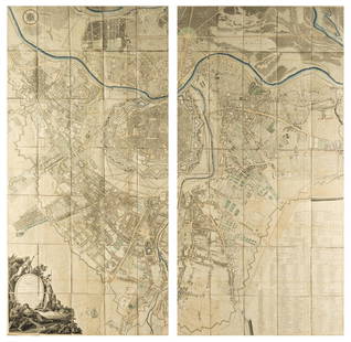
Sold2023Plan de la Ville et Fauxbourgs de ParisPlan de la Ville et Fauxbourgs de Paris, 1763 historic wall map of Paris, 1777 "Divise en 20 quartiers dont la plus grande partie a ete rectifiee" by Debarme paper size 60" x 70 1/2", frame size 62" xSee Sold Price
Sold2022Plan de Paris 1927 Made for Washington Sq. BookPlan de Paris map by Ilonka Karasz printed for sale at the Washington Square Bookshop in 1927. Measures 27.5 in. x 36 in. and folds to 14 in. x 9 in. Loose in a leatherette folio. Color with gilt on tSee Sold Price
Sold2022Engraving of Guillaume DHEULLAND Plan de la Ville de Paris 1756This is Dheulland's historical view of Paris, a fascinating mid-18th century piece showing the city as it stood during the reign of Charles IX, that is, sometime between 1560 and 1574. Published in PaSee Sold Price
Sold2016Manifiesto a la Nacion. Adhesion al Plan de Guadalupe.Manifiesto a la Nacion. Adhesion al Plan de Guadalupe. Piedras Negras, Coahuila, Marzo 27 de 1913.See Sold Price
Sold2016"Plan de la Nouvelle Orleans," by Jacques Nicolas"Plan de la Nouvelle Orleans," by Jacques Nicolas Bellin, Paris, 1764, hand colored copper engraving, depicting the French Quarter, with a list of keys across the top and turbulent waves of the MissisSee Sold Price
Sold2018Austria.- Grimm (Maximilian von) Grundriss der Kl: Kl:Austria.- Grimm (Maximilian von) Grundriss der Kl: Kl: Haupt und Residenzstadt Wien mit ihren Vorstadten nach den Neuen Hausnumern 1797 / Plan de la Ville de Vienne et de ses Fouxbourgs avec le DenombSee Sold Price
Sold2021Jacques Nicolas Bellin MapsJacques Nicolas Bellin , "Plan de La Nouvelle Orleans" and "Carte des Embouchures du Mississipi", two hand-colored engraved maps, from Le Petit Atlas Maritime, 1764, 7 1/2 in. x 11 in., framed . ProveSee Sold Price
Sold202119th Century Map of MemphisPLAN DE LA VILLE DE MEMPHIS (ETATS-UNIS) 40,000 HABITANTS pen and ink with watercolor hand drawn drainage system map, circa 1870. Depicts a grid street plan of the city of Memphis with labeled streetSee Sold Price
Sold2019Rare map of the Bosphorus, 1788Heading: Author: Maire, François Joseph Title: Plan de Constantinople et du Bosphore pour Servir de Renseignement a la Carte des Limites des Trois Empires, ou Theatre de la Guerre Presente Place PubSee Sold Price
Sold2016Large plan of Paris 1814Heading: Author: Bonnisel, J. Title: Plan de la Ville et Faubourgs de Paris avec ses Monuments… Place Published: Paris Publisher: Date Published: 1814 Description: EngravedSee Sold Price
Sold2022Nicolas de La Mare (French, 1639–1723), Antoine Coquart (French, 1668–1707), and Nicolas de FerNicolas de La Mare (French, 1639–1723), Antoine Coquart (French, 1668–1707), and Nicolas de Fer (French, 1646-1720), "Cinquieme Plan de la Ville de Paris," c. 1705, hand-colored map, preSee Sold Price
Sold2016c. 1770 Georgeous Hand-Colored Plan of BostonColonial America Hand-Colored Plan of Boston Town and Harbor by Bellin c. 1770 Colonial Era, “Plan de la Ville de Boston et Ses Environs,” Jacques Nicolas Bellin, Choice Crisp Extremely Fine. ThisSee Sold Price
Sold2023Delisle Map of Paris, France, Hand Colored 1716Important Map of Paris by Guillaume De L'Isle, Full Title: Plan de la Ville et Fauxbourgs de Paris. Dressee sur les observations astronomiques de l'Academie Royale des Sciences et sur les operations gSee Sold Price
Featured3 days LeftJasper521724-6 Valentijn View of Cambodia's Lovek -- Eauweck, Hoofd-Stad van Cambodia$160
5 days LeftMynt AuctionsChristian Dior LADY D-LITE Medium Handbag Plan de Paris Embroidery M0565OOMP_M993 Cotton Made in$5
Jul 16BADO e MART AUCTIONSNautical Chart. TARDIEU – BESANCON. Plan de la Baie de Espirito Santo.€500
3 days LeftJasper521714 Chatelain Map of Moscow with Coats of Arms -- Carte du Gouvernement Civil et Ecclesiastique de$240
6 days LeftSwann Auction Galleries(MEXICAN IMPRINT--1618.) [Diego Cisneros.] [Sitio, naturaleza y propriedade dela ciudad de Mexico,$600
3 days LeftJasper521774 FRENCH HISTORY ANECDOTES of CHINA JAPAN SIAM TONKIN LAOS CAMBODIA antique$220
3 days LeftJasper521696 De Romana Republica by Petro Cantelio ILLUSTRATED antique ARMORIAL VELLUM$280
5 days LeftForum Auctions[Hobbes (Thomas)] De mirabilibus Pecci: being the Wonders of the Peak, in Darby-shire, first£200


![Plan scenographique de la Cité des Rois ou Lima'. Peru.: TITLE/CONTENT OF MAP: 'Plan scenographique de la Cité des Rois ou Lima, Capitale du Royaume de Perou [Scenographic plan of the City of Kings, or Lima, capital of the Kingdom of Peru]' DATE PRINTED: 1](https://p1.liveauctioneers.com/5584/139429/70692658_1_x.jpg?height=310&quality=70&version=1554845662)


![[CHINA] CHARPENTIER DE COSSIGNY, JOSEPH FRANCOIS. Voyage a Canton, capitale de la province de ce: [CHINA] CHARPENTIER DE COSSIGNY, JOSEPH FRANCOIS. Voyage a Canton, capitale de la province de ce nom, a la Chine; par Gorée, le Cap de Bonne Espérance, et les Isles de France et de la Reunio](https://p1.liveauctioneers.com/292/263885/137590406_1_x.jpg?height=310&quality=70&version=1664914638)


![(MEXICAN IMPRINT--1618.) [Diego Cisneros.] [Sitio, naturaleza y propriedade dela ciudad de Mexico, (1 of 1)](https://p1.liveauctioneers.com/199/334052/180498088_1_x.jpg?height=282&quality=70&version=1718909401)


![[Hobbes (Thomas)] De mirabilibus Pecci: being the Wonders of the Peak, in Darby-shire, first (1 of 1)](https://p1.liveauctioneers.com/5458/333399/180018785_1_x.jpg?height=282&quality=70&version=1718372581)


