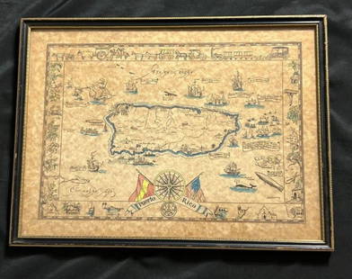
Sold2022EBK Dooley Hand Colored Puerto Rico Pictorial MapAntique hand colored map of Puerto Rico by EBK Dooley (Eliza Bellows King Dooley), published 1931. No tares and color it still vibrant.See Sold Price
Sold2023Vintage Hand -Colored Pictorial Map of Puerto Rico Circa 1931 by E.B.K. DooleyA vintage hand-colored map of Puerto Rico by E.B.K. Dooley, published c. 1931. This map has a decorative border filled with local plants, wildlife, buildings and transportation. In small scrolls, therSee Sold Price
Sold2021Antique MapsGrouping of Two (2) Antique Engraved Maps. Includes a J.H. Colton & Co hand colored map of Cuba, Jamaica, and Puerto Rico together with a Jacques-Nicolas Bellin "Carte de la Nouvelle Angleterre, NouveSee Sold Price
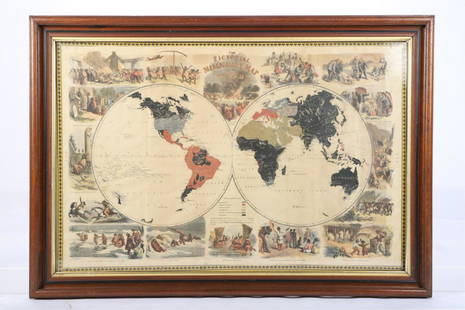
Sold2020Illustrated Van Loon Hand-Colored World Map, 1932Hendrik Willem Van Loon (Dutch-American, 1882-1944). Illustrated World Map, 1932. A hand colored outlined pictorial map of the world on Mercator projections with topographical relief shown pictoriallySee Sold Price
Sold2023Antique 1853 Hand Colored United States of America Pictorial Map Thayer Bridgman Fanning PublishersDescribed By:Michelle NODD HFA DBJQ Title:Antique 1853 Hand Colored United States of America Pictorial Map Thayer Bridgman Fanning Publishers Description: Antique 1853 Hand Colored United States of AmSee Sold Price
Sold2021Pictorial Map of Nantucket by Austin StrongHand colored in original and great condition, professionally matted and framed, c. 1921, 14 H inches x 17 W inches sight, 23 H inches x 26 W inches, overall. Austin Strong (1881-1952)Austin Strong, stSee Sold Price
Sold2022Marvelous pictorial map of the WorldHeading: (Maps) Author: Ensign & Thayer Title: World at One View Place Published: New York Publisher: Date Published: 1847 Description: Lithographed double-hemisphere map of theSee Sold Price
Sold2020Small Hand-Colored Map of Nantucket by William SchontzeSmall Hand-Colored Map of Nantucket by William Schontzeler,rare pictorial map of Nantucket in original frame, signed, l.r William Cotton Schontzeler, trained as a draftsman in NY, he owned and workedSee Sold Price
Sold2024Pictorial Map of the United States, 1849PICTORIAL MAP OF THE UNITED STATES 1849. New York: Ensign and Thayer, [ca. 1849.] Sheet 44" x 32.25".*** An attractive hand-colored map providing a view of the United States as it was in the mid-19thSee Sold Price
Sold20231859 Cuba, Jamaica and Puerto Rico. By ColtonTitle: 1859 Cuba, Jamaica and Puerto Rico. By Colton Date/Period: 1859 Materials: Hand colored steering engraved Size: 17 1/2 x 14 1/2” Cuba, Jamaica, and insert of Puerto Rico. 1859. By J. H. CSee Sold Price
Sold2022Lloyd Coe Hand Colored Map of Marthas VineyardLloyd Coe Hand Colored Map of Marthas Vineyard, measures 28 x 21 inches, wood frame, surface wear to frame, professionally framed, not examined out of frame. Pictorial map of Marthas Vineyard, a summeSee Sold Price
Sold2021Angel Botello (Spanish/Puerto Rico, 1913-1986)Angel Botello (Spanish/Puerto Rico, 1913-1986) "Girl With Starfish", ca. 1975 hand-colored linocut on black Arches paper signed lower right, numbered "1/100" lower left, marked "RR" upper left, afterSee Sold Price
Sold2021Arrowsmith's large map of America 1804Heading: Author: Arrowsmith, Aaron Title: Map of America Place Published: London Publisher:A. Arrowsmith Date Published: 1804 Description: Engraved map, hand-colored, with uncolSee Sold Price
Sold2021PICTORIAL MISSIONARY MAP OF THE WORLDHand colored lithograph featuring map of the globe with vignettes of the introduction of Christianity in various cultures of the world, published in 1861, sight size 18 3/4 x 28 3/4 inches, set in oriSee Sold Price
Sold201818th C. Map of Australia w/Strait of Magellan18th c. framed map of Australia w/the Strait of Magellan. Copper engraved map, hand colored, w/ large colored pictorial cartouche, by Bernaidus Joannis Manasterienfis. Visible paper measures approximaSee Sold Price
Sold2016Map of Milan region Italy 1640Heading: Author: Blaeu, Willem Title: Stato di Milano Place Published: Amsterdam Publisher: Date Published: c.1640 Description: Copper-engraved map, hand-colored in outline; colSee Sold Price
Sold2023Colton's Cuba, Jamaica and Porto Rico. Puerto Rico. Bahamas 1869 old mapTitle: Colton's Cuba, Jamaica and Porto Rico. Puerto Rico. Bahamas 1869 old map Description: Colton's Cuba, Jamaica and Porto Rico' by Joseph Hutchins Colton (1869). Antique engraved hand coloured atlSee Sold Price
Sold20221846 Pictorial View of the World, by Phelps, NYHistoric Maps "Pictorial View of the World 1846" Map by Phelps 1846-Dated, Hand-Colored Printed Broadside Poster, "Pictorial View of the World. - 1846" With a Map of the World, Showing a List of "DistSee Sold Price
Sold2017Blaeu map of Cyprus c.1640Heading: Author: Blaeu, Willem Title: Cyprus Insula Place Published: Amsterdam Publisher: Date Published: c.1640 Description: Copper-engraved map, hand-colored in outline,See Sold Price
Sold2023Johnson's Cuba, Jamaica & Porto Rico. Puerto Rico. Bahamas Florida Keys 1861 mapTitle: Johnson's Cuba, Jamaica & Porto Rico. Puerto Rico. Bahamas Florida Keys 1861 map Description: Johnson's Cuba, Jamaica and Porto Rico' by Alvin Jewett Johnson (1861). Large, decorative hand coloSee Sold Price
Sold2021(16) 19TH C. MAPS OF THE WEST INDIES IN FOLIO,Including: "L'Isle de Ste. Domingue, et celle de Porto Rico", by Bonne, hand colored engraving,1778, 10" x 14 1/2"; PLUS "West Indies", Smith's Atlas, 1808, hand colored engraving, 1808, 11" x 14"; PLSee Sold Price
Sold2022(PICTORIAL MAPS.) The Crawfords. Group of 24 hand-printed textile maps.(PICTORIAL MAPS.) The Crawfords. Group of 24 hand-printed textile maps. Variously colored screen-prints on cotton fabric. Approximately 12x18 inches each; occasional light foxing. Jamestown, RI, lateSee Sold Price
Sold2022Map of Cuba, Jamaica & Puerto Rico, J. H. ColtonAn excellently colored map of these islands. Nice impression. Shows railroads, roads, towns, coastal features, islands, topography, bays. Extremely light toning at paper edges. Inset of Porto Rico. 12See Sold Price
May 26Ararity AuctionsThomson's 1817 Hand Colored Map Comparative Heights of the World's Great Mountains$50
5 days LeftBlackstone Valley Auctions & Estates LLCRevolutionary Era War Map of the Attack on Ft. Moultrie.$225(3 bids)
13 hrs LeftFleischer's Auctions1755 Map Partie de l'Amerique Septentrionale, qui comprend Le Cours de L'Ohio...$200(3 bids)
4 days LeftAlbion AuctionsClarke & Russell 1814 Hand Col Map. Canada - British Dominions in North America$25(3 bids)


![Pictorial Map of the United States, 1849: PICTORIAL MAP OF THE UNITED STATES 1849. New York: Ensign and Thayer, [ca. 1849.] Sheet 44" x 32.25".*** An attractive hand-colored map providing a view of the United States as it was in the mid-19th](https://p1.liveauctioneers.com/3532/326332/175680404_1_x.jpg?height=310&quality=70&version=1713150771)