Sold2022Map of Paris, 16th century, FramedBraun and Hogenberg, "Lutetia, vulgari nomine Paris," from CIVITATES ORBIS TERRARUM (Cologne: G. von Kempen, first published 1572, then through several editions over 50 years); engraving with hand colSee Sold Price
Sold2024ANTIQUE MAP - REPRESENTATION OF THE TURKISH EMPIRE IN THE 16TH C.16TH C. FRAMED HAND COLORED ANTIQUE MAP - ABRAHAM ORTELIUS (BELGIAN, 1527-1598) REPRESENTATION OF THE TURKISH EMPIRE IN THE 16TH C. - TITLED "TURCICI IMPERII DESCRIPTO" - FRAME MEASURES APPROX. 23 1/2See Sold Price
Sold2024LATE 16TH C. MAP OF SCOTLAND BY MERCATOR, FRAMEDSouthern Scotland, from Mercator's Atlas "sive Cosmographicae Meditationes de Fabrica Mundi" (Duisberg, ca 1595), copperplate engraving on wove paper, with handcoloring, center fold as issued. In goldSee Sold Price
Sold20231500's Hand Colored Bookplate Map of Grodno, LithuaniaAn 16th century hand-colored bookplate map of Grodno, Lithuania. Framed, it measures 32" tall X 34" across.See Sold Price
Sold2022Map of Paris 1576Map of Paris French Munster copy of 16th Century Walled City Framed Great Graphics & Really Interesting Map print not engraving Great Vintage Condition Measuring 18" x 17" Out of New York City EstateSee Sold Price
Sold2021Early Hand-Colored Map of VeniceItaly, ca. 16th-17th century. Fine hand-colored engraved map of "Venetia" with boats in harbor and compass rose. Handsomely framed. MEASUREMENTS Sight wide: 5 7/8 / 15 cm. Sight height: 4 1/2 / 11.5 cSee Sold Price
Sold2022THREE HAND-COLORED MAPSTHREE HAND-COLORED MAPS1) “Insulae Indiae Orientalis” from the Mercator/Hondius Atlas Minor, Mid-16th Century. 6” x 7.75” sight. Framed 12.25” x 14.25”.2) "DeSee Sold Price
Sold2019MEDIEVAL ILLUMINATED VELLUM SHEET MUSIC MANUSCRIPTProbably 16th /17th Century double sided sheet music written in Latin on Vellum paper. Framed under glass in a Greek Key border frame. It measures 21" x 15"See Sold Price
Sold201716TH C. MAP OF NEW GUINEA16th Century map of the coast identifying Sierra Leone by the Portuguese. Dimensions: (Frame) H 19.5" x W 23.75" (Sight) H 13.75" x W 19.5" Condition: Foxing to mat. Wear to frame.See Sold Price
Sold202216TH C. MAP OF AMSTERDAM BY BRAUN & HOGENBERG"Amstelredamum, Nobile Inferioris Germaniae Oppidum (..)" by Frans Hogenberg (1535-1590) / Georg Braun (1541-1622). Handcolored copperplate engraving, perspective map with buildings, from the first paSee Sold Price
Sold2019Framed 16th C. Spanish Hymnal Page**Originally Listed At $350** Europe, Spain, ca. 1520s to 1530s CE. A hand inscribed hymnal leaf in red and black on vellum (a high-quality sheet made out of stretched and scraped calfskin). Just likeSee Sold Price
Sold202116TH C. GREEK ORTHODOX BRONZE CROSS PENDANTHollow cast Cross with engraved figure of Christ offering Benediction, inscription at top, 2 3/4" x 1 1/4". Edge loss at back, nice patina.See Sold Price
Sold2023FRIES EARLY 16TH C. MAP BLACK FORESTWoodcut, double-sided. Dates to c. 1522/1535. With center fold as published. Dimensions: (Paper) H 16" x W 20.75" Condition: Light age toning to margins. Otherwise bright.See Sold Price
202316th c. Map, Israel, Middle East - TRIBUS ASER by Christian van AdrichomDescription16th c. Engraved Map of Israel, Middle East - TRIBUS ASER [Territory of the Tribe of Asher in the Holy Land] by Christiaan van Adrichem, (1533-1585) and Arnold Mylius (1540-1604) | PublisheSee Sold Price
Sold2023OVERSIZED REPRODUCTION OF A 16TH C. MAPMonumental and highly decorative offset lithograph reproduction map of the world by Giovanni Marfei after Abraham Ortelius, originally published c. 1589 or 1593. Dimensions: (Frame) H 45" x W 84" CondSee Sold Price
Sold2022Antique 16th Century Map South AmericaTitle: Antique 16th Century Map South America Description:Antique 16th Century Map South America Circa Date: 1598 Condition of piece: Map displays toning, some water stains, wrinkles and creases,See Sold Price
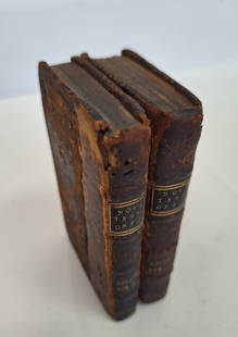
Sold2023Pair 16th Century Greek BiblesA pair of A. Plantin Greek New Testament Bibles from 1574. 4 1/8" Tall, 2 1/2" Wide. Overall average condition for age, covers show notable wear, pages and binding are intact, show some wear, the prinSee Sold Price
Sold2017Late 16th Century Maps, Incl. Siege of La Rochelle &Two maps on one sheet. Hand-colored map of Ghent (approx. 8.5 x 11 in.), tipped onto reverse side of page with map of the Siege of La Rochelle (approx. 8.25 x 11 in. plate size). Both maps printed witSee Sold Price
Sold2017European School (16th century), Map of "PersiaEuropean School (16th century), Map of "Persia (Sophorum Regnum), Armenia, Assyria, Mesopotamia et Babylonia," hand-colored copper engraving, overall (with frame): 14.25"h x 16.5"w. Property from theSee Sold Price
Sold2018Late 16th century map of CyprusLate 16th century map of Cyprus. Frame H 23" W 26.5", map H 14" W 16.25"See Sold Price
Sold201816th century map of Europe by Georg Hoefnagel16th century map of Europe by cartographer Georg Hoefnagel,hand colored. Frame :"21.75 x 25"; map:14"x 17.75".(From Wiki):"Georg (Joris) Hoefnagel was the son of the diamond trader Jacob Hoefnagel andSee Sold Price
Sold202316th CENTURY MAP of ARMENIA BLACK & CASPAN SEA REGION by PTOLEMY ANTIQUEWOOD ENGRAVED HAND COLORED MAP of ARMENIA , BLACK & CASPAN SEA REGION from DELLA GEOGRAFIA DI TOLOMEO c. second half of 16th century Overall size 9 by 12 1/4" Very good condition Reserve: $104.00 ShipSee Sold Price
Sold201816th century map of Limburg by Georg Braun16th century map of Limburg by Georg Braun. Map: 19.75"x 12.25" in a frame: 27.25"x 20".See Sold Price
4 days LeftJasper521762 d'Anville Map of Ancient Greece -- Graeciae Antiquae Specimen Geographicum$80
4 days LeftJasper521733 c. DeLisle Map of Ancient Northern Greece -- Graeciae Pars Septentrionalis$95
4 days LeftJasper521752 Robert de Vaugondy Map of Middle East and Ancient Empires -- Antiquor Imperiorum Tabula, in qua$140
4 days LeftJasper52Title/Content of Map: Puerto Rico: Port of Guánica by Ferrer Date Printed: 1818$55
4 days LeftJasper521775-1780 North & South Carolina, Georgia and Virginia. By Bonne & Raynal$160(1 bid)
4 days LeftJasper521893 Civil War Map of Siege of Yorktown, Battle of Siloh and Army of Ohio Operations -- Plan of$55
Featured4 days LeftJasper521875, Brooklyn Bridge under Construction, Prospect Part, sites in the Holy Land. By Hardesty$20
4 days LeftJasper52Title/Content of Map: Haiti: Fondeadero de Chouchou (N. coast of Haiti) and Bahia de la Granja by$55
Featured4 days LeftJasper521831 Woodbridge Map of South America and Africa -- Comparative, Geographical & Statistical Map of$70
4 days LeftJasper521747 Homann Map of Czech Rep., Silesia and Parts of Germany -- Regni Bohemiae, Duc. Silesiae,$110
4 days LeftJasper521775-1780 Uruguay, Northern Argentina, Southern Brazil, and Rio de Janeiro. By Bonne & Raynal$25(1 bid)
4 days LeftJasper52Title/Content of Map: Jamaica: port of Bahía de Lucea [Lucea Bay] by Ferrer Date Printed: 1818$55


![16th c. Map, Israel, Middle East - TRIBUS ASER by Christian van Adrichom: Description16th c. Engraved Map of Israel, Middle East - TRIBUS ASER [Territory of the Tribe of Asher in the Holy Land] by Christiaan van Adrichem, (1533-1585) and Arnold Mylius (1540-1604) | Publishe](https://p1.liveauctioneers.com/6084/291748/157234438_1_x.jpg?height=310&quality=70&version=1689539413)


![[MAP]. ORTELIUS, Abraham. Turcici Imperii Descriptio.1592. (1 of 2)](https://p1.liveauctioneers.com/197/329395/177650538_1_x.jpg?height=282&quality=70&version=1715364962)


![Pittsburg [Sic] and Vicinity. (1 of 1)](https://p1.liveauctioneers.com/5584/331064/178466317_1_x.jpg?height=282&quality=70&version=1716924723)
![Title/Content of Map: Jamaica: port of Bahía de Lucea [Lucea Bay] by Ferrer Date Printed: 1818 (1 of 1)](https://p1.liveauctioneers.com/5584/331064/178466334_1_x.jpg?height=282&quality=70&version=1716924723)