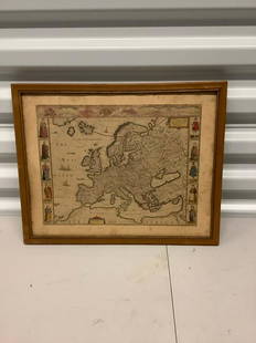
Sold2021Antique Framed Map of Europe, Europa Guilielmo BlaeuwAntique Color Map of Europe, Dutch Cartography. "Europa Recens Descripta" by Guilielmo Blaeuw, a cartographer for the Dutch East India Company. Lots of colorful detail of different nationalitiSee Sold Price
Sold20231769 ANTIQUE MAP of EUROPE framed EUROPEAN POSTAL ROADS & STATIONS1769 ANTIQUE MAP: MAPPA GEOGRAPHICA EXHIBENS POSTAS omnes tam vehiculares quam verdarias Totius Germaniae cum earum accurata distantia Diligentissime propriis sumptibus excudit. Aug. Vindelicor. : TobSee Sold Price
Sold2021Antique Diagrammatic Road Map of Central EuropeAntique Framed Diagrammatic Road Map of Central Europe by Wood McMurtry. Measures 22 inches high by 28 inches wide.See Sold Price
Sold2020Antique Map of Europe Glued on a CanvasAntique Map of Europe Glued on a Canvas. Beautifully Framed. Condition: Generally good. Dimensions: Sight- 36"x27", Frame- 43"x34". Provenance from a Long Island NY Estate. Please note the absence ofSee Sold Price
Sold2024Antique Europe Map/ France. Pieced down in sections. Sight size 26-1/2 x 36 inches. Overall framedAntique Europe Map/ France. Pieced down in sections. Sight size 26-1/2 x 36 inches. Overall framed size is 32 x 42 inchesSee Sold Price
Sold2024Two (2) Antique 18th C. Copper Engraved Framed Maps - America & EuropeTwo (2) antique 18th C. copper engraved framed maps. One of Amerique and other titled Carte d'Europe. Both framed under glass. Frame Size: 13.5H x 14.5W (each)See Sold Price
Sold20231782 COPPERPLATE ENGRAVED MAP OF EUROPEOriginal antique copperplate engraved map of “Europe” engraved for Baldwins New Complete and Universal System of Geography. Published by Thomas Conder circa 1782.Professionally framed andSee Sold Price
Sold2020AN ANTIQUE MAP, "Europe (Evrop)," JOHN SPEED,AN ANTIQUE MAP, "Europe (Evrop)," JOHN SPEED, CARTOGRAPHER, 1626-1676, hand-colored engraving on paper, Abraham Goos (1589-1643), engraver, published for merchants Thomas Basset and Richard Chiswell iSee Sold Price
Sold20222 PC. FRAMED ANTIQUE MAPS OF ISRAEL2 PC. FRAMED ANTIQUE MAPS OF ISRAEL: Comprising; 1- Detailed Ortelius Map of the Holy Land, Based on Tilemann Stella's Extremely Rare Holy Land Maps. 1- Homann based this map of the Holy Land on the cSee Sold Price
Sold2020Framed Antique Map Orbis Vetus, Robert De VaugondyItem/Description: Old print. Map of the world by Robert de Vaugondy from 1752. Orbis vetus in utraque continente : In both the old continent / world map / Vaugondy 1752. Material: Print framed under gSee Sold Price
Sold20182 Framed antique maps2 Framed antique maps, probably from an old atlas, British America & The United States, map drawn & engraved by J. Rapkin, illustrations by H. Warren & illustrations by R. Wallis, Maps are 10" x 13",See Sold Price
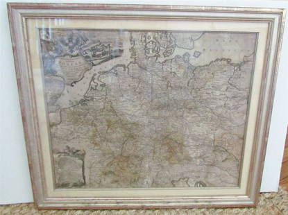
Sold2021Framed Antique Map of Northwest Germany, DeutschlandFramed Antique Map of Northwest Germany. Nicely framed in dark wood with an interior gold border and off-white mat. Tag on the back, which is wood-covered, shows the location of the map within DeutschSee Sold Price
Sold2020FRAMED ANTIQUE MAP OF THE WORLDFRAMED ANTIQUE MAP OF THE WORLD, ROBERT DE VAUGONDY, ORBIS VET US, 1752, GEOGRAPHO REGIS ORDINARIO. PAPER IS ACID BURNED AND FOLDED IN THE CENTER. Height: 27 & 19 1/2 in. by Width: 36 1/2 & 29 in.See Sold Price
Sold2021de Fer, Nicolas 1717 Antique Map. Europe"L'Europe Suivant les Nouvelles Observations" Copper Engraved Map Published 1717, Paris for "Introduction a la Geographie" by Nicolas de Fer. Folds as issued. Paper Size: 14 x 10 inch (36 x 25cm) GoodSee Sold Price
Sold2024Antique Map - Europe - Italy With the Islands of Sicily, Corsica and SardiniaMap of iItaly with the islands of Sicily, Sardinia and Corsica by Francois Halma, 1700. Decorative large map of Italy, with an elaborate cartouche.See Sold Price
Sold2022Butler, Samuel 1842 Antique Map. EuropeSteel Engraved Map Published 1842, London for "An Atlas of Modern Geography" by Samuel Butler. Drawn & Engraved by Sidney Hall. Centre fold as published. Original outline hand colour. Paper Size: 10.5See Sold Price
Sold2023"Orbis Romani Pars Occidentalis" Framed Antique Map by Charles Smith c1820s"Orbis Romani Pars Occidentalis" Framed Antique Map by Charles Smith c1820s.See Sold Price
Sold2021Barlow 1807 Antique Map. EuropeCopper Engraved Map Published 1807 by Brightly & Kinnersley, Bungay, England for "A General View of the World, Geographical, Historical and Philosophical" by The Rev. E. Blomfield. Engraved by Barlow.See Sold Price
Sold2024Cooke, George 1801 Antique Map. EuropeCopper Engraved Map Published 1801-07 by Macdonald & Son, London for "Modern and Authentic System of Universal Geography" By George A. Cooke. Folds as issued. Paper Size: 12.5 x 10 inch (32 x 26cm) ApSee Sold Price
Sold2024Russell, J. 1804 Antique Map. EuropeCopper Engraved Map with outline hand color Published 1804 by W. Peacock, London for "A Compendious Geographical Dictionary" Drawn and Engraved by J. Russell. Folds as issued. Paper Size: 6.5 x 5 inchSee Sold Price
Sold2023Brookes & Baker 1797 Antique Map. EuropeCopper Engraved Map Published 1797, London for "The General Gazetteer; Or, Compendious Geographical Dictionary" by Richard Brookes. Engraved by B. Baker. Original outline hand color. Folds as issued.See Sold Price
Sold2023Barclay, James 1808 Antique Map. EuropeCopper Engraved Map Published 1806, London for "Barclay's Complete and Universal English Dictionary" by the Rev. James Barclay. Paper Size: 10 x 8 inch (26 x 21cm) Margin tear, otherwise Good ConditioSee Sold Price
6 hrs LeftTrillium Antique Prints & Rare BooksPtolemy & Magini, pub. 1620 - Map of the Ancient World with Africa, Europe, Asia$50