Sold2021Large scale map of Paris in oak frameLarge scale Map of Paris ("Carte Particuliere des Environs de Paris") in oak frame. Originally designed in 1674 by Francois de La Pointe for the Royal Academy. This version dates to early 20th centurySee Sold Price
Sold2017Bellin: Antique Map of Mexico City Region, 1754Map: Carte des Environs de la Ville de Mexico Cartographer: Bellin Place & Date: Paris / 1754 Size: 6 3/4" x 8 3/4" Condition: outline color; overall age toning Bellin's detailed map of the environs oSee Sold Price
Sold2021Carte De La Grande BretagnePublication Date: 1744 Title: Carte De La Grande Bretagne Cartographer: DESBRUSLINS, F. PERE Publisher: BUFFIER Height: 7 Width: 5.5 Sur les degres de l'Academie des Siences [sic] de Paris. 1744." FroSee Sold Price
Sold2024Barthelemy, Jean 1790 Map. Greece - Plan des Environs d'Athenes AthensCopper Engraved Map Published 1790, Paris for "Recueil de Cartes Geographiques, Plans, Vues et Medailles de L'Ancienne Grece, Relatifs Au Voyage du Jeune Anacharsis" by Jean Jacques Barthelemy. CentreSee Sold Price
Sold20201757 Bellin Carte Du Lac De Mexico1757 Map by Jacques Bellun entitled "Carte Du Lac De Mexico Et De Ses Environs Lors de la Conqueste des Espagnols", printed at Paris. From his work "L'Histoire Generale des Voyages", Fine, measures 7See Sold Price
Sold2018Bellin: Antique Map of Course of the Amazon, 1754Title/Content of Map: Carte du Cours du Maragnon ou de la Grande Riviere des Amazones Cartographer: Bellin Place & Date: Paris / 1754/1760 Size: 14 5/8" x 6 7/8" Condition: b&w; old folds; light overaSee Sold Price
Sold2020Carte Des Environs De La Ville De Mexico PourTitle: Carte Des Environs De La Ville De Mexico Pour L'histoire Gene. Des Voyages. 1754. Publication Date: 1754 Cartographer: BELLIN, JACQUES NICOLAS, ELDER (1703-1772) Publisher: DIDOT Brief DescriptSee Sold Price
Sold20221754 Bellin Map of Mexico City and Surroundings -- Carte des Environs de la Ville de MexicoTitle: 1754 Bellin Map of Mexico City and Surroundings -- Carte des Environs de la Ville de Mexico Cartographer: J Bellin Year / Place: 1754, Paris Map Dimension (in.): 8 X 6.4 in. This a very nice maSee Sold Price
Sold2017Nouvelles Maisons Des Environs De Paris by Cesar DalyItem: Nouvelles Maisons Des Environs De Paris by Cesar Daly, steel engraving, circa 1880s Dimensions: 17x12 in Please note that this lot has a confidential reserve. When you leave a bid in advance ofSee Sold Price
Sold2018Bellin: Maps/Views of Aztec & Colonial Mexico CityTitle/Content of Map: Carte des Environs de la Ville de Mexico / Ancien Mexico [and on a second sheet] Nouveau Mexico / Carte du lac de Mexico et de ses Environs Cartographer: Bellin / Chedel Place &See Sold Price
Sold20229 Lithograph 1830 Victor Adam Fetes des Environs DePortfolio of 9 Lithograph 1830 Victor Adam Fetes des Environs De Paris And 1 Booklet Trois Contes de Notre Dame, 9" X 6", Good condition. HANDLING and SHIPPING For USA $10. FOR INTERNATIONAL SHIPPING,See Sold Price
Sold2022Gabriel Perelle (French, 1604-1677)Gabriel Perelle (French, 1604-1677), "Nouvelles Cascades pour St. Cloud", etching, printed by Nicolas Langlois, Paris, from Vues des Belles Maisons des Environs de Paris sheet 8 1/2 in. x 12 1/2 in.,See Sold Price
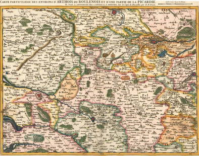
Sold2016Environs De Cambray Bappaumes, St Quentin. Jean CovensCarte Particuliere Des Environs De Cambray Bappaumes, St Quentin, Perone Maker: Covens, Jean. Origin: Amsterdam, 1730. Medium: Original copper plate engraving with later hand-coloring. Sheet size: 21See Sold Price
Sold2016Environs De Cambray, Bappaumes, St. Quentin, PeroneCarte Particuliere Des Environs De Cambray, Bappaumes, St. Quentin, Perone Maker: Fricx, Eugne Henri. Origin: Brussels, 1710. Medium: Original engraving with early hand-coloring Sheet size: 24 x 21 inSee Sold Price
Sold2022Carte Routiere Pour Automobilistes & Cyclistes - Environs De Paris, Section Nord-EstPublication Date: c1914 Title: Carte Routiere Pour Automobilistes & Cyclistes - Environs De Paris, Section Nord-Est Cartographer: A. Taride Publisher: A. Taride Height: 25.5 Width: 33.3 Large map showSee Sold Price
Sold201618th C. map of BermudaCarte des Isles Bermudes ou de Sommer, Paris 1764. Hand colored copperplate engraving From Bellin's Petit atlas maritime.Tome I N.48 Plate XXXIII. Frame under glass, not inspected out of the frame. 8"See Sold Price
Sold2022France.- Vues d'Optique.- Rigaud (Jacques) Five platesFrance.- Vues d'Optique.- Rigaud (Jacques) Five plates from 'Recueil choisi des plus belles vues des palais, châteaux et maisons royales de Paris et des environs', including Versailles, ThuilleriSee Sold Price
Sold2021[ARCHITECTURE] 2 ILLUSTRATED PORTFOLIOS[ARCHITECTURE] Portfolios with engravings and lithographs. Daly, Cesar. L'ARCHITECTURE PRIVEE AU XIXe SIECLE, NOUVELLES MAISONS DE PARIS AT DES ENVIRONS. Paris: Ducher & Co. 1872. Cloth portfolio, spiSee Sold Price
Sold2018ANTIQUE ICON & ANTIQUE PARIS ITINERARY MAPHand painted icon signed & dated 1832 - 12.25" h x 9.25" w plus antique Carte Routiere De Dion-Bouton Environs De Paris itinerary mapSee Sold Price
Sold2018ANTIQUE ICON & ANTIQUE PARIS ITINERARY MAPHand painted icon signed & dated 1832 - 12.25" h x 9.25" w plus antique Carte Routiere De Dion-Bouton Environs De Paris itinerary mapSee Sold Price
Sold20191792 Elwe Map of Indian Ocean Islands -- Parte de laTitle: 1792 Elwe Map of Indian Ocean Islands -- Parte de la Nouvelle Grande Carte des Indes Orientales, Contenant les Isles Maldives, Ceylan, Malacca, Sumatra &c. Avec Les Terres Adjacentes De CouchinSee Sold Price
Sold20191792 Elwe Map of India and Southeast India -- Partie DeTitle/Content of Map: 1792 Elwe Map of India and Southeast India -- Partie De La Nouvelle Grande Carte Des Indes Orientales, Contenant Les Terres Du Mogol, Surate,Malabar, Coromandel, Bengale, Aracan,See Sold Price
Sold2018Map of the Society Islands, 1787Heading: Author: Bonne, Rigobert Title: Carte des Isles de la Societé Place Published: Paris Publisher: Date Published: 1787 Description: Copper-engraved map, later hand-coSee Sold Price
Sold2016Jan Barend Elwe, "Partie de la Nouvelle Grande CarteJan Barend Elwe, "Partie de la Nouvelle Grande Carte des Indes Orientales", Amsterdam, 1792, 22-1/4" x 26-1/4" sight, 31-1/2" x 35" overall, center crease, multiple tears and losses to edgesSee Sold Price
6 days LeftSwann Auction Galleries(CHESAPEAKE -- VIRGINIA.) Gilles and Didier Robert de Vaugondy. Carte de la Virginie et du Maryland$600
14 hrs LeftLeon GalleryPhilippe de Pretot, Etienne Andre (c. 1710 - 1787) and William Walton - Carte de Canal des Isles₱30,000
Featured5 days LeftJasper52Cartes des Isles Britanniques qui renferment… British Isles DELAMARCHE 1804 map$260
5 days LeftJasper52Cartes des Isles Britanniques qui renferment… British Isles VAUGONDY 1780 map$260
6 days LeftSwann Auction Galleries(ROMAN ARCHITECTURE.) Charles Percier; and P.F.L. Fontaine. Choix des Plus Celebres Maisons de$375
BonhamsAFRICA L'Afrique suivant les dernières observations de M. Hass... Paris, Georges-Louis Le R...£70(8 bids)
Jun 22Jeschke Jadi Auctions Berlin GmbHJR JR au Louvre et le Secret de la Grande Pyramide. 2022. Farblithographie auf Velin. 90,5 x 47 cm€600
2 days LeftWorthington GalleriesAntique L'ANNÉE LITURGIQUE LE CARÊME R.P. Dom Prosper Guéranger, 19th Édition$10
2 days LeftWorthington GalleriesAntique PETIT LAROUSSE ILLUSTRE; NOUVEAU DICTIONNAIRE ENCYCLOPEDIQUE, 1917$10(1 bid)
Jun 30Global Auctions CompanyAfter J Vernet Engraving J Jacques Le Veau Vue des Environs de Bayonne c1750-85$100
Jun 21Hannam's Auctioneers LtdHenri Abraham Chatelain (1684-1743) Map, Carte Des Indes, De La Chine & Des Iles De Sumatra & Java.£5
7 days LeftLeland LittleGeorges van der Straeten (1856-1928), Art Nouveau Bust of a Woman with Cherries$50


![Carte De La Grande Bretagne: Publication Date: 1744 Title: Carte De La Grande Bretagne Cartographer: DESBRUSLINS, F. PERE Publisher: BUFFIER Height: 7 Width: 5.5 Sur les degres de l'Academie des Siences [sic] de Paris. 1744." Fro](https://p1.liveauctioneers.com/5584/220201/113214910_1_x.jpg?height=310&quality=70&version=1633469264)


![Bellin: Maps/Views of Aztec & Colonial Mexico City: Title/Content of Map: Carte des Environs de la Ville de Mexico / Ancien Mexico [and on a second sheet] Nouveau Mexico / Carte du lac de Mexico et de ses Environs Cartographer: Bellin / Chedel Place &](https://p1.liveauctioneers.com/5584/114563/58815203_1_x.jpg?height=310&quality=70&version=1514941693)


![[ARCHITECTURE] 2 ILLUSTRATED PORTFOLIOS: [ARCHITECTURE] Portfolios with engravings and lithographs. Daly, Cesar. L'ARCHITECTURE PRIVEE AU XIXe SIECLE, NOUVELLES MAISONS DE PARIS AT DES ENVIRONS. Paris: Ducher & Co. 1872. Cloth portfolio, spi](https://p1.liveauctioneers.com/1124/208511/106199060_1_x.jpg?height=310&quality=70&version=1624388585)


