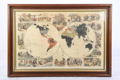
Sold2018Group of [4] World Maps by Various CartographersGroup of four World Maps by various cartographers and publishers. 1) W. Houghs "The World as Known to the Ancients" published by A. & C. Black. Measures 17.5" x 12.5" sheet size. 2) Engraved by J. WilSee Sold Price
Sold2019Mitchell: Australia & Pacific Islands with Hawaii InsetTitle: Map of Oceanica, Exhibiting its Various Divisions, Island Groups &c. Cartographer: S. A. Mitchell Place/Date: Philadelphia / 1867/1870Size: 13 1/4" x 10 3/4" Condition: full color; overall ageSee Sold Price
Sold2023Cartography12. Cartography.Group of 4 maps, as listed below. Various sizes; light wear. Vp, vd [75/100]Russia in Europe. Plate 21 of Johnston's National Atlas. 25-1/2 x 21 inches. 1850s * ditto. Plate 55 of MitcSee Sold Price
Sold20234 WWII Silk Pilots Escape or Invasion MapsGroup of 4 World War II era silk Air Force pilots escape maps, one of Sicily and Italy, Ryojun, Manchuria/Pei-P'Ing China, Otomari, Japan/Vladimiro-Aleksandrovskoye, Greece/Bulgaria-Romania 15" x 19"-See Sold Price
Sold2020Group of 4 Maps from Independence to SecessionGrouping of 4 maps from the same book pertaining to various time periods in American history. The first is page 189 and depicts Period IV, 1773 - 1789, 16 years, Independence. The second depicts PerioSee Sold Price
Sold2023Maps of the World, France, Washington D.C., and Historical Portfolio of the United States, Group ofLot 53 Maps of the World, France, Washington D.C., and Historical Portfolio of the United States, Group of 4 comprising Map of the World showing the Western Pacific Railway Company and Toyo Kisen KaiSee Sold Price
Sold2022Group of 4 Original US World War II Posters LARGE SIZE + 1Various ArtistsWorld War II (4 + 1 Posters)Offset ca. 1942Condition Details: (B/B-) incl 5 posters, 2 in the largest format 60x40 in./152x101 cm, -Flag Banner- 17x100 in./43x255 cm, -War Stamps- 10x60See Sold Price
Sold2021Group of 4 1933 Century of Progress Worlds FairIncludes a bag from the Hungarian Pavilion, a promotional Guide and map, a book on The Chinese Lama Temple, and an indexed map.See Sold Price
Sold2017World Coins - Judea - Mixed Bronzes Group [4]1st century BC-1st century AD. Group comprising: various small bronze issues; several types represented. 19.32 grams total. ("). [4, No Reserve]See Sold Price
Sold2020Grp: 54 Maps of the World 18th and 19th c.Group of 54 maps of various regions of the world, dating from the 18th and 19th century. Foldable Map of Navarre on paper attached to linen, Tomás López de Vargas Machuca (1730-1802) "Map of theSee Sold Price
Sold2018Rare Miniature African American Vienna BronzesGroup Of 4 Rare Miniature African American Vienna Bronzes, Poly Chromed. Various Activities Dimensions- H- Tallest Figure- 1 1/2" From A New Jersey EstateSee Sold Price
Sold2019Barlow 1807 Group of 4 European MapsIncl Russia, England/Wales, Sweden/Denmark/Norway/Finland and Turkey in Europe. Copper Engraved Maps Published 1807 by Brightly & Kinnersley, Bungay, England for "A General View of the World, GeographSee Sold Price
Sold2015World Coins - Mixed Coins Group [110]19th-20th century AD. Group comprising: Australia (4; including 1924 florin, good fine); Belgium (18; various issues); Bermuda (1; crown, 1964); Canada (1; 1 cent, 1918); Chile (1; half decimo, 1892);See Sold Price
Sold2022MITCHELL'S UNIVERSAL ATLASNew Universal Atlas Containing Maps of the various Empires, Kingdoms, States, and Republics of the World, S. Augustus Mitchell, Philadelphia, 1847; Condition: boards detached; 17 1/4 x 14 inchesSee Sold Price
Sold20221881 Selchow and Richter Puzzle of Various Nations -- Sliced Nations…Title/Content of Map: 1881 Selchow and Richter Puzzle of Various Nations -- Sliced Nations… Cartographer: Selchow and Richter Year/Place: 1881, Bay Shore New York Size: 19 X 28.4 in. Solved puzzSee Sold Price
Sold2018Five Vintage World's Fair Souvenir Canes.Lot of Five Vintage World's Fair Souvenir Canes. Two 1933 Chicago and three 1939 New York. Including a New York 1939 World's Fair pull-out map cane. Largest measures 38-1/4"l. Condition: Good with weaSee Sold Price
Sold2021A Group of 11 19th and 20th century maps, comprising:A Group of 11 19th and 20th century maps, comprising: Ethnographic Map of the World. Edinburgh and London: William Blackwood & Sons, N.d.. Plate 23. 17 1/4 x 19 1/2 in. -- Geographical Division & DistSee Sold Price
Sold2021PICTORIAL MISSIONARY MAP OF THE WORLDHand colored lithograph featuring map of the globe with vignettes of the introduction of Christianity in various cultures of the world, published in 1861, sight size 18 3/4 x 28 3/4 inches, set in oriSee Sold Price
Sold2023WORLD WAR I ACES (16)A great group of 16 items by noted aces of World War I, in various formats (noted). Includes: RON CUNDY (two signed cards and signed FDC honoring Edmond Thieffry, canceled 1978); FREDDIE WEST (S.P. 4See Sold Price
Sold2023Group of Antique Polar Maps (4)Four Antique maps relating to the polar regions. The World in Three Sections, Alexander Hogg. North Pole, Emanuel Bowen. North Pole from Carey's Edition of Guthrie's Geography Improved. Polus ArcticusSee Sold Price
Sold2015World Coins - India - Madurai Navakas (4), Tinnevelly1st-18th century AD. Group comprising: Madurai Navakas, kasu (4); Tinnevelly Navakas, kasu and 2 kasu (4); southern India (including Mysore, Tanjore, Basksalobe and Maharastan), various issues (15); sSee Sold Price
Sold2023Group of 14 Decorative PrintsGroup of 14 decorative prints, 19th and 20th century, depicting various European cities, a small map and postcards, some signed, most framed. [Largest: 14" H x 15 3/4" W]. Losses to some works and fraSee Sold Price
Sold2018A Twenty-Nine Piece Group Of Tiffany & Co. FlatwareA Twenty-Nine Piece Group Of Tiffany & Co. Flatwaremarks: Tiffany & Co., Sterling; Hh, (Various)9-3/4 Inches (24.8 Cm)19.78 Troy Ounces The Lot Comprising:9 Seafood Forks;12 Citrus Spoons;6 Demitasse;See Sold Price
Sold2023Assembled Group of Collectible StampsAssembled group of 12 folders of stamps, including "Mint Stamps of the World" and "UNICEF Flags of the United Nations", together with various loose country postage stamps. [Folder: 14 1/4" H x 12 3/4"See Sold Price
May 16Potter & Potter Auctions[WORLD WAR II]. Group of 4 propaganda posters. 1940s. Inclu...$70(1 bid)
6 hrs LeftMatthew Bullock AuctioneersGroup of 4 The Century Atlas 1890s - 1900s Antique Maps$15(1 bid)


![Group of [4] World Maps by Various Cartographers: Group of four World Maps by various cartographers and publishers. 1) W. Houghs "The World as Known to the Ancients" published by A. & C. Black. Measures 17.5" x 12.5" sheet size. 2) Engraved by J. Wil](https://p1.liveauctioneers.com/5755/131248/66701959_1_x.jpg?height=310&quality=70&version=1542156595)
![Group of [4] World Maps by Various Cartographers First Image](https://p1.liveauctioneers.com/5755/131248/66701959_1_x.jpg?height=300&quality=1&version=1542156595&width=300)
![Group of [4] World Maps by Various Cartographers First Image](https://p1.liveauctioneers.com/5755/131248/66701959_1_x.jpg?height=300&quality=95&version=1542156595&width=300)

![Cartography: 12. Cartography.Group of 4 maps, as listed below. Various sizes; light wear. Vp, vd [75/100]Russia in Europe. Plate 21 of Johnston's National Atlas. 25-1/2 x 21 inches. 1850s * ditto. Plate 55 of Mitc](https://p1.liveauctioneers.com/1352/285291/150515655_1_x.jpg?height=310&quality=70&version=1684408824)


![World Coins - Judea - Mixed Bronzes Group [4]: 1st century BC-1st century AD. Group comprising: various small bronze issues; several types represented. 19.32 grams total. ("). [4, No Reserve]](https://p1.liveauctioneers.com/1191/111015/57011595_1_x.jpg?height=310&quality=70&version=1508497819)


![World Coins - Mixed Coins Group [110]: 19th-20th century AD. Group comprising: Australia (4; including 1924 florin, good fine); Belgium (18; various issues); Bermuda (1; crown, 1964); Canada (1; 1 cent, 1918); Chile (1; half decimo, 1892);](https://p1.liveauctioneers.com/1191/77013/40263931_1_x.jpg?height=310&quality=70&version=1440503883)


![Group of 14 Decorative Prints: Group of 14 decorative prints, 19th and 20th century, depicting various European cities, a small map and postcards, some signed, most framed. [Largest: 14" H x 15 3/4" W]. Losses to some works and fra](https://p1.liveauctioneers.com/1221/303742/163526795_1_x.jpg?height=310&quality=70&version=1697648988)


![[WORLD WAR II]. Group of 4 propaganda posters. 1940s. Inclu... (1 of 5)](https://p1.liveauctioneers.com/928/325952/175495307_1_x.jpg?height=282&quality=70&version=1712935174)
![[WORLD WAR I]. Group of 4 American propaganda posters. Circ... (1 of 5)](https://p1.liveauctioneers.com/928/325952/175495306_1_x.jpg?height=282&quality=70&version=1712935174)


![Tokens - Mixed 17th Century - AE Trade Token Group [4] (1 of 1)](https://p1.liveauctioneers.com/1191/327727/176560300_1_x.jpg?height=282&quality=70&version=1714130530)
![Ancient Greek Coins - Mixed AE Group [4] (1 of 1)](https://p1.liveauctioneers.com/1191/327727/176559796_1_x.jpg?height=282&quality=70&version=1714130530)