Sold2022Impressive vintage Colton map of MaineReally nice original vintage map from the very uncommon 1857 Colton General Atlas. (See description of 1857 Colton atlas in item 215-22). Shows highly detailed representation of the coastal features oSee Sold Price
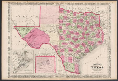
Sold2023Excellent example of Johnson’s Texas, 1866Authentic and impressive vintage map of Texas. One of the more collectible maps to be produced in the mid-19th century. A highly desirable map that details the state in full. Shows the elevated TableSee Sold Price
Sold2022Exceptional map of Johnson's Texas, 1866Authentic and impressive vintage map of Texas. A highly desirable map that details the state in full. Shows the elevated Table Lands, the U. S. Mail Route, the Staked Plain (El Llando Estadado), numerSee Sold Price
Sold2021Impressive 1854/56 Colton map of LouisianaBeautiful map of Louisiana with 1854 date. From Colton’s 1856 Atlas of the World, one of the best American atlases of the mid-19th century. Detailed map with decorative border, colored by parish andSee Sold Price
Sold20191855 Colton Map of Maine -- MaineReserve Reduced! Title/Content of Map: 1855 Colton Map of Maine -- Maine Date: 1855, New York Cartographer: J Colton Size: 15.5 X 12.3 in. This is a very nice map of Maine. Great deal of detail is proSee Sold Price
Sold2021Vintage Maps of Maine Topography MapsVintage Maps of Maine Topography Maps These two maps were drawn out in the early 1900s and then reprinted. The maps we have are vintage reprints and educational with information on how to read topograSee Sold Price
Sold2022Nice 1860 map of Maine with full hand coloringVery nice vintage map of Maine with original hand coloring by county. Features signature floral border that makes Mitchell maps stand apart. Railroads clearly delineated and named. Shows coastal featuSee Sold Price
Sold2018Colton: Antique Map of Maine, 1859Title/Content of Map: Maine by Colton Date Printed: 1859 Cartographer: H.J. Colton Material/Medium: Paper Size: 17 1/2" x 15" Hand colored,engraved. Published in New York in 'Colton's General Atlas.'See Sold Price
Sold2017Colton: Antique Map of Maine, 1861Title/Content of Map: Colton's Maine Date Printed: 1861 Cartographer: J.H. Colton Material/Medium: Paper Size: 14" x 17" Hand colored, steel engraved. From 'Colton's General Atlas. Published in New YoSee Sold Price
Sold2022Exact Chart of the River St. Laurence, Thomas Jeffreys c1775Historically important chart published during the American Revolutionary War. An incredibly impressive and large vintage map in immaculate condition. Contains geographical and navigational data alongSee Sold Price
Sold2019Colton's Maine Map [N. Atlantic States]Colton's Maine Map. J. H. Colton Cartographer. Published by J. H. Colton, New York. Stamped 'Entered according to Act of Congress in the Year 1855 by J. H. Colton and Co. in in the Clerks Office of thSee Sold Price
Sold2021Vintage county and RR map of Maine by Mitchell, 1860Title: Vintage county and RR map of Maine by Mitchell, 1860 Description: Beautiful map of the unique state of Maine with hand coloring by county. Maine, our eastern-most state, is surrounded by anotheSee Sold Price
Sold2021Fine map of Palestine, Colton 1886Title: Fine map of Palestine, Colton 1886 Description: Impressive and highly detailed map of Palestine from the very scarce 1890 edition of Colton’s General Atlas. This is the only edition of this aSee Sold Price
Sold2021Vintage Philadelphia MapVintage Philadelphia Map, J.H. Colton & Co. Publishers 1855, with street names and public sites; matted in wood frame 17 1/4" x 20 3/4". CONDITION: Small edge tear on bottom left. Not examined out ofSee Sold Price
Sold2022Elusive map of Maine from scarce Colton atlasUnusual map of Maine with hand coloring down to the township level. On this map railroad lines are depicted as tiny railroad tracks. Map is dated 1855; it’s taken from a scarce copy of ColtonSee Sold Price
Sold2018Colton's MaineTitle: Colton's Maine Publication Date: 1872 Cartographer: COLTON, G.W. & C.B. Publisher: G.W. & C.B. COLTON & CO. Size: 14X11 Scarce Pocket Map of Maine. Map detailing counties, many towns, townshipsSee Sold Price
Sold2022Fine Colton map of Vermont by ColtonScarce Colton’s Vermont map in impressive, clean condition with no faults. From the only known example of Colton’s 1890 General Atlas (Rumsey notes 1888 as the last edition). Highly detaSee Sold Price
Sold2021Lovely 1854/56 Colton map of GeorgiaImpressive and clean 1854 map of Georgia from Colton's 1856 Atlas of the World. Highly detailed and hand colored by counties. Shows roads, railroads, towns, villages, post offices, rivers, lakes, statSee Sold Price
Sold2021Clean vintage map of China (wide margins) (1883)Title: Clean vintage map of China (wide margins) (1883) Description: Lovely map of China with huge margins. From the 1883 Unrivaled Family Atlas by George F. Cram. Will make an impressive display whenSee Sold Price
Sold2021Clean Mountains & Rivers, Colton 1890Title: Clean Mountains & Rivers, Colton 1890 Description: Vintage double-page pictorial map of comparative sizes of the world’s mountains and rivers in most likely the last edition of Colton’s GenSee Sold Price
Sold2023VINTAGE STATE MAPS / TRAVEL EPHEMERA, UNCOUNTED LOTVINTAGE STATE MAPS / TRAVEL EPHEMERA, UNCOUNTED LOT,for states Maine, Maryland including Baltimore, Massachusetts including Boston, and Michigan, with Shell and Conoco examples.20th century. ProvenancSee Sold Price
Sold2021Scarce Colton 2-page map of Texas, c1884Breathtakingly large, fully hand-colored vintage map of Texas from the very scarce 1890 edition of Colton’s General Atlas. This is the only edition of this atlas that I’ve ever seen—See Sold Price
Sold2021Ethel B Fowler 1931 Boothbay Harbor Maine MapEthel B Fowler; The Bridge House Studio, 1931 Vintage "Boothbay Harbor and Vicinity" Maine Historical map, mixed media print or Poster, signed and dated in the art and framed. Height of art 24 1/2 incSee Sold Price
Sold2021Impressive map of Louisiana, O. W. Gray, 1875Title: Impressive map of Louisiana, O. W. Gray, 1875 Description: Great vintage hand colored map of this beautiful Gulf state. Wonderful detailing of the southern marshy areas along the coast, and nicSee Sold Price
9 mins LeftRapid Estate Liquidators and Auction Gallery1856 Mississippi Map & Info Published By J.H. Colton & Co. No.172 William St. New York$45
3 days LeftJasper521865 Colton Map of US Southwest -- Colton's Map of California, Nevada, Utah, Colorado, Arizona & New$160


![Colton's Maine Map [N. Atlantic States]: Colton's Maine Map. J. H. Colton Cartographer. Published by J. H. Colton, New York. Stamped 'Entered according to Act of Congress in the Year 1855 by J. H. Colton and Co. in in the Clerks Office of th](https://p1.liveauctioneers.com/5755/154409/77936952_1_x.jpg?height=310&quality=70&version=1573094011)


