Sold2017Janssonius: Map of Ancient Germany, 1645TITLE/CONTENT OF MAP: 'Germaniae Veteris Nova Descriptio [Ancient Germany newly described]' A map of ancient Germany, based on Ortelius' map, which was in turn based on the writings of Ptolemy, Pliny,See Sold Price
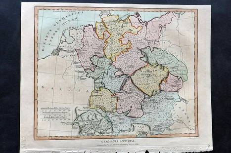
Sold2021Wilkes, John 1807 Hand Col Map. Ancient Germany"Germania Antiqua" Finely Hand Colored Copper Engraved Map Published 1796-1828 London for "Encyclopaedia Londinensis, or universal dictionary of arts, sciences and literature" by John Wilkes et al. PaSee Sold Price
Sold2016Map of Ancient Germany by JanssonHeading: Author: Jansson, Jan Title: Germaniae Veteris, Typus Place Published: Amsterdam Publisher: Date Published: c.1640 Description: Copper-engraved map, hand-colored inSee Sold Price
Sold2018Arrowsmith: Antique Map of Ancient Germany, 1828TITLE/CONTENT OF MAP: 'Germania; Vel Regiones intra Rhenum f1. Oceanum, Sinum Codanum, Vistulam f1. Montes Sarmaticos et Danubium f1. Sitae' DATE PRINTED: 1828 IMAGE SIZE: Approx 25.5 x 28.5cm, 10 x 1See Sold Price
Sold20211828 Map of Ancient GermanyAuthor: Hall Title: 1828 Map of Ancient Germany Materials: Ink on Paper Dimensions: 10.5"X8.5" Description: Map of Ancient Germany dated 1828. Part of Butler's Antique World Atlas. Drawn and engravedSee Sold Price
Sold2019Delamarche, Felix 1829 Maps (2) Ancient France, Germany"Germania Antiqua" and "Galliae Antiquae" Copper Engraved Maps Published 1829, Paris for "Atlas de La Geographie..." by Felix Delamarche. Contemporary outline hand colour. Centre fold as published. PaSee Sold Price
Sold20241839. Ancient Germania and Central Europe by MoninTitle/Content: 1839. Ancient Germania and Central Europe by Monin Date: 1839 Medium: Hand colored, engraved Dimensions: 17 1/2" x 12 1/2" Description: Map of Ancient tribal Germany and Central Europe.See Sold Price
Sold2017Janssonius: Antique Map of Portugal, 1645Title: Portugallia et Algarbia quae olim Lusitania. Attractive mid-17th century map of Portugal Map maker: Jan Janssonius Place and Year: Amsterdam, [c.1645] Dimensions: 38.5 x 49.5 cm (15¼ x 19½ inSee Sold Price
Sold2022Maps 1812-1922 Mixed Lot of 46 MapsLot of Lithograph and Engraved Maps. Incl Netherlands, Ancient World, Europe, Greece, Germany, Madedonia, North America, Canada, Netherlands, USA, Malaya, European Battle Plans, Australia, New ZealandSee Sold Price
Sold2022Ancient map of a region of Bavaria, 1628Authentic vintage map of the Rhineland Palatinate of Bavaria in Southern Germany. From an edition of Mercator’s Atlas Minor. Jocodus Hondius created the Atlas Minor in 1607 as a smaller versionSee Sold Price
Sold2021Dussieux, Louis 1859 Mixed Lot of 6 MapsIncl Europe, UK, France, French Empire, Ancient Britain/Germany and Persian Empire/Asia Minor. Steel Engraved Map Published 1859, Paris for "Atlas Complet de Geographie Elementaire" by Louis Dussieux.See Sold Price
Sold2019Maps 19th Cent. Mixed Lot of 11Incl Belgium/Netherlands, Lake Gennesaret, France, Camp of Colonias, Denver, Canaan, Ancient World, Coal Mine Map, Germany and Lake States of the US. Examples by Bryce, Chambers, Encyclopaedia BritannSee Sold Price
Sold2019Delamarche, Felix 1829 Lot of 6 Ancient Europe MapsIncl Ancient France, Spain, Germany, Greece, Alexander the Great Empire, and Asia Minor. Copper Engraved Maps Published 1829, Paris for "Atlas de La Geographie..." by Felix Delamarche. Contemporary ouSee Sold Price
Sold2022Maps 1816-1922 Mixed Lot of 21 Antique MapsIncl Australia, Pacific, USA, North America, and Ancient - Italy, France, Germany, Spain. Examples by Bartholomew, Encyclopaedia Britannica, National Encyclopedia and Cellarius & Patrick. Paper Size:See Sold Price
Sold2018Janssonius Map of East coastJANSSONIUS, Joannes. Nova Anglia Novum Belgium et Virginia. Copperplate engraving. Amsterdam, 1636 (first State). Burden 247. 18 3/4 x 22 1/2 inches sheetSee Sold Price
Sold2016Janssonius Map of Northwest South AmericaTerra Firma et Novum Regnum Granatense et Popayan. Jan Janssonius (1588-1664). Engraved map with original hand color in full. Amsterdam, 1640. 15 1/4 x 20 inches visible, 24 x 28 inches framed. ShowsSee Sold Price
Sold2023MAP, Germany, Braun & HogenbergMainz & Wurzburg, Germany & Sion, Switzerland. Braun & Hogenberg, Moguntia, Germaniae Metropolis, ad Rheni... [on sheet with] Herbipolis, Comuniter Wirtzburg... [and] Sedunum, Primaria & MetropoliticaSee Sold Price
Sold2022Ancient Germany and Poland. 1701-1706 by Christoph CellariusTitle: Ancient Germany and Poland. 1701-1706 by Christoph Cellarius Date/Period: 1701-1706 Materials: Copperplate engraved Size: 13x9" Shows the areas north of the Roman conquered regions. Mainly tribSee Sold Price
Sold2023MAP, Germany, MunsterSouthern Germany. Sebastian Munster, Das Algow, from Cosmographey oder Beschreibung Aller Laender, 1578 (published). Hand Color. This charming woodblock map of southwestern Bavaria oriented with northSee Sold Price
Sold2022MAP, Germany, JanssonSoutheastern Germany. Jan Jansson, Franconiae Nova Descriptio, from Atlas Novus..., 1646 (circa). Hand Color. This elegantly engraved map focuses on the Franconia region of Germany, located in BavariaSee Sold Price
Sold2018FRAMED MAP, GERMANY NORTH OF THE MAYNEFramed map, "Germany, North of the Mayne", drawn and engraved for Thomson's New General Atlas, 1816, London engraved, hand colored highlights, sight approx: 20"h, 24.5"w, overall: 30"h, 34.5"w, 10.5lbSee Sold Price
Sold201918th C Map Ancient World JerusalemEngraved plate showing maps of ancient world including inset of Judea and Samaria and one of Jerusalem. Early 18th century.Very Good, trimmed to plate lines, measures 7 x 5.5". Reserve: $20.00 ShippinSee Sold Price
Sold2017Mallet: Antique Map, Ancient Conception of the UniverseTitle/Content of Map: Du Globe Terrestre : Globe de Mella; Globe de Posidonius; Globe de Ptolomee. Ancient Conceptions of the Universe Date Printed: 1683 Cartographer: Allain Manesson Mallet Size (in)See Sold Price
Sold202118th C Large Handcolored Mercator Map GermanyLarge beautifully handcolored map of Braunswyck and Meydburg after Gerard Mercator circa 1640, this being an 18th century restike.. Printed at Amsterdam. Measures 23 x 19". Fine, reinforced central veSee Sold Price
May 14Hermann Historica GmbHA German seal from a member of the patrician family Welser, 19th century€720
4 days LeftTrillium Antique Prints & Rare BooksPtolemy & Magini, pub. 1620 - Map of the Ancient World with Africa, Europe, Asia$50
497 Lots AwayJasper521720 antique MAP of LOWER SAXONY GERMANY 18th CENT. Circulus Saxoniae inferioris$75
4 days LeftTrillium Antique Prints & Rare BooksDe Jode, Rare, pub. 1593 - Map of Part of Germany (Sveviae Utriusq cum Germicae tum Rheticae$100
4 days LeftTrillium Antique Prints & Rare BooksDe Jode, Rare, pub. 1593 - Map of Austria (Austriae Ducatus Seu Pannoniae Superioris?)$100
May 12Schilb Antiquarian Rare Books1859 AFRICA VOYAGES Barth Timbuktu Tripoli SLAVES Illustrated Slavery MAP African$62(4 bids)


![Janssonius: Map of Ancient Germany, 1645: TITLE/CONTENT OF MAP: 'Germaniae Veteris Nova Descriptio [Ancient Germany newly described]' A map of ancient Germany, based on Ortelius' map, which was in turn based on the writings of Ptolemy, Pliny,](https://p1.liveauctioneers.com/5584/103242/52831744_1_x.jpg?height=310&quality=70&version=1493321322)


![Janssonius: Antique Map of Portugal, 1645: Title: Portugallia et Algarbia quae olim Lusitania. Attractive mid-17th century map of Portugal Map maker: Jan Janssonius Place and Year: Amsterdam, [c.1645] Dimensions: 38.5 x 49.5 cm (15¼ x 19½ in](https://p1.liveauctioneers.com/5584/110975/56961897_1_x.jpg?height=310&quality=70&version=1508432804)


![MAP, Germany, Braun & Hogenberg: Mainz & Wurzburg, Germany & Sion, Switzerland. Braun & Hogenberg, Moguntia, Germaniae Metropolis, ad Rheni... [on sheet with] Herbipolis, Comuniter Wirtzburg... [and] Sedunum, Primaria & Metropolitica](https://p1.liveauctioneers.com/6576/279721/147265449_1_x.jpg?height=310&quality=70&version=1677104593)


