Sold2022Animals and productivity of the world in two maps. 1862Title: Animals and productivity of the world in two maps. 1862 by Johnson and Ward Date/Period: 1862 Materials: Steel plate engraved. Size: 19" x 14" 1862 from 'Johnson's New Illustrated Family Atlas'See Sold Price
Sold2023Royal Geographical Society Silver Map #2. Framed Engraved Metal World Map. PTOLEMY version. Issued bRoyal Geographical Society Silver Map #2. Framed Engraved Metal World Map. PTOLEMY version. Issued by the FRANKLIN MINT; Limited Edition. 1976. Thin sterling sheet laid on wood. Deaccessioned from TheSee Sold Price
Sold2017Fantastic Dutch 17th C. map of Japan & adjacent islandsA nice Dutch map of Japan and adjacent islands by Joan Jansson, c. 1660. Title: New and Accurate Japan, Land of Ezo and Adjacent Islands, fully hand-colored with 2 Compass Roses, 4 Galleons and a SeaSee Sold Price
Sold2020Lot of 4 Table Lighters Lighter/Case Combo & Kent FrameLot of 4 Table Lighters (Crystal w/ Chip shown, Brown & Bigalow Statesman Rememberance World Map, M.T.C. Japan & Elite) Lighter/Case Combo (Evans) & a Kent Cigarettes Advertising picture Frame - see pSee Sold Price
Sold2018Rand, McNally & Co.'S Indexed Atlas of the World Map ofReserve Reduced! Title/Content of Map: Rand, McNally & Co.'S Indexed Atlas of the World Map of Japan.Date: 1892 Cartographer: RAND, MCNALLY & CO. Material/Medium: RAND, MCNALLY & CO. Size: 19 x 25.8 iSee Sold Price
Sold2020Illustrated Van Loon Hand-Colored World Map, 1932Hendrik Willem Van Loon (Dutch-American, 1882-1944). Illustrated World Map, 1932. A hand colored outlined pictorial map of the world on Mercator projections with topographical relief shown pictoriallySee Sold Price
Sold2017Bachiene: Kaart van Chili, 1785Map: Kaart van Chili Cartographer: Bachiene Place & Date: Amsterdam / 1785 Size: 8 1/2" x 13 A beautifully colored exemplar of the scarce Dutch version of Bonne's map of Chili and the southern cone ofSee Sold Price
Sold2021WWII UNITED PRESS WAR MAP w 7 INDIVIDUAL MAPS JAPANTitle: WWII UNITED PRESS WAR MAP w 7 INDIVIDUAL MAPS JAPAN HAWAII WORLD PACIFIC THEATER Additional Information: WWII UNITED PRESS WAR MAP w 7 INDIVIDUAL MAPS JAPAN HAWAII WORLD PACIFIC THEATER WWII UNSee Sold Price
Sold20221930AD Japanese pre-world war II City Maps1930AD Japanese pre-world war II City Maps Reserve: $40.00 Shipping: Domestic: Flat-rate of $10.00 to anywhere within the contiguous U.S. International: Foreign shipping rates are determined by destinSee Sold Price
Sold20201930 Japanese Mainichi Newspaper World Air RouteTitle: 1930 Japanese Mainichi Newspaper World Air Route Pictorial Map -- Conquer Sky Sugoroku [World Air Route Map] Cartographer: Mainichi Newspaper Year / Place: 1930, Osaka Map Dimension (in.): 26.8See Sold Price
Sold2016Unknown - Japanese Map Of The World; People Of ManyUnknown - Japanese Map Of The World; People Of Many NationsSee Sold Price
Sold2018Hand Colored Map of the World, Willem BlaeuWillem Blaeu, (Dutch, 1571-1638) "Nova Totius Terrarum Orbis Geograhica ac Hydrographica" originally published 1606 Nice old color example of Blaeu's classic world map Approx. 19.5" x 25.5" (unframed)See Sold Price
Sold2023Large 1719 Dutch bible published by Pieter Keur, Amsterdam. Illustrated with numerous engravings ofLarge 1719 Dutch bible published by Pieter Keur, Amsterdam. Illustrated with numerous engravings of biblical scenes and a double page world map. Tooled full leather binding with heavy brass mounts andSee Sold Price
Sold2024World Map Print "Nova Totius Terrarum Orbis" by Willem Blaeu - Dutch circa 1606World Map Print "Nova Totius Terrarum Orbis" by Willem Blaeu - Dutch circa 1606. Matted and framed Old World brought forward in the piece both colorful and detailed. Measures H 29" x W 35" and weightSee Sold Price
Sold2019Bartholomew, John 1922 Pair of Large Maps of JapanLarge Lithograph Map Published 1922 by The Times, London for "The Times Survey Atlas of the World" Maps by John George Bartholomew of the Edinburgh Geographical Institute. Centre fold as issued. PaperSee Sold Price
Sold2019Bartholomew, John 1922 Pair of Maps of JapanLarge Lithograph Maps Published 1922 by The Times, London for "The Times Survey Atlas of the World" Maps by John George Bartholomew of the Edinburgh Geographical Institute. Centre fold as issued. PapeSee Sold Price
Sold2020Bartholomew, John 1922 Pair of Maps of JapanLarge Lithograph Maps Published 1922 by The Times, London for "The Times Survey Atlas of the World" Maps by John George Bartholomew of the Edinburgh Geographical Institute. Centre fold as issued. PapeSee Sold Price
SoldVisscher:Visscher: Hemisphere world map. Surrounded by landscapes of the world and how they were divided and inhabited by Noah’s descendants. Dutch text to verso. c.1700, Hand-coloured, 30 x 44cm; Plus:See Sold Price
Sold20245 U.S. fighter pilot China-Japan escape cloth mapsHeading: (China - World War II escape map) Author: Title: Five US Army Air Force pilot silk escape maps of China and Japan from World War II Place Published: Washington, D.C. Publisher:Army Map ServiSee Sold Price
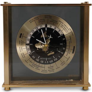
Sold2020Seiko World Desk ClockDESCRIPTION: A Seiko desk clock. Features a world map dial with white colored hands and airplane motif seconds hand. Marked "Seiko, Quartz Japan" Finished with time zone markers and a gilt brass case.See Sold Price
Sold2020Group Collections of Photography,Letters and MapsGroup collections of Japanese occupied Nanking in World War II. 2 military maps. 2 photography album included 293 pieces photos . One Japanese Bowl.See Sold Price
Sold2016Map of China & Japan, 1868Original engraving from Johnson's Atlas of the World, 1868. Map includes vignette of Canton and details cities, towns and territories. Dimensions: 18" x 26". This item ships from Ocean View, DE.See Sold Price
Sold2024Group of 7 Mattel Dolls of the World Collection Barbie Fashion DollsIncludes Japanese, Jamaican, Dutch, and more. 11 1/2 inches tallSee Sold Price
Sold20195" JAPAN STORYBOOK DOLL AROUND THE WORLD SERIES "DUTCH"5" JAPAN STORYBOOK DOLL AROUND THE WORLD SERIES "DUTCH" #27 IN ORIGINAL COSTUME. "MADE IN JAPAN" MARK ON JOINTED PT BISQUE BODY WITH MOLDED SOCKS/BANGS AND TOPKNOT. NO BOX.See Sold Price
1 day LeftJasper52World showing Dutch East India Co Possessions, c1720, CA as a island. By J.Malherbe$550
3 days LeftForum AuctionsGeology.- Bristow (Henry William) The Geology of the Isle of Wight, hand-coloured maps, 1862 &£50
3 days LeftDutch Auction SalesRare Book Sir Walter Raleigh History of the World 1614 1st Edition$500(1 bid)
BonhamsWORLD MAP. LOON, JAN VAN. C 1611-1686. Orbis Terrarum Nova et Accuratissima tabula. [Oxford: Mo...$2,400
2 days LeftDOYLE Auctioneers & AppraisersAn attractive eighteenth-century Dutch map of the Americas$150
17 hrs LeftFreeman's | Hindman[Early Printing] [Incunable] (Macrobius, Ambrosius Aurelius Theodosius: In Somnium Scipionis exposit$300


![1930 Japanese Mainichi Newspaper World Air Route: Title: 1930 Japanese Mainichi Newspaper World Air Route Pictorial Map -- Conquer Sky Sugoroku [World Air Route Map] Cartographer: Mainichi Newspaper Year / Place: 1930, Osaka Map Dimension (in.): 26.8](https://p1.liveauctioneers.com/5584/187575/94368587_1_x.jpg?height=310&quality=70&version=1607465981)


![[Early Printing] [Incunable] (Macrobius, Ambrosius Aurelius Theodosius: In Somnium Scipionis exposit (1 of 3)](https://p1.liveauctioneers.com/65/332523/179335062_1_x.jpg?height=282&quality=70&version=1717709446)