Sold2023Johnson & Exley 1812 Antique Folio Map. World HemispheresCopper Engraved Map Published 1812, London for "The Imperial Encyclopaedia; Or, Dictionary of the Sciences and Arts" by William Moore Johnson & Thomas Exley. Paper Size: 17 x 10.5 inch (43 x 27cm) WatSee Sold Price
Sold2023Johnson & Exley 1812 Antique Map. North AmericaCopper Engraved Map Published 1812, London for "The Imperial Encyclopaedia; Or, Dictionary of the Sciences and Arts" by William Moore Johnson & Thomas Exley. Paper Size: 10.5 x 8.5 inch (27 x 22cm) WaSee Sold Price
Sold2024Johnson & Exley 1812 Antique Map. AfricaCopper Engraved Map Published 1812, London for "The Imperial Encyclopaedia; Or, Dictionary of the Sciences and Arts" by William Moore Johnson & Thomas Exley. Paper Size: 10.5 x 8.5 inch (27 x 22cm) WaSee Sold Price
Sold2023Russell & Barclay C1825 Antique Folio Map. World Hemispheres"New World of Western Hemisphere" "Old World or Eastern Hemisphere" Copper Engraved Map Published C1825., by Fisher & Son, "A Complete Atlas of the World" by John Russell et al. The companion Atlas toSee Sold Price
Sold2023Johnson & Exley 1812 Antique Map. England & WalesCopper Engraved Map Published 1812, London for "The Imperial Encyclopaedia; Or, Dictionary of the Sciences and Arts" by William Moore Johnson & Thomas Exley. Paper Size: 10.5 x 8.5 inch (27 x 22cm) WaSee Sold Price
Sold2023Johnson & Exley 1812 Antique Map. AsiaCopper Engraved Map Published 1812, London for "The Imperial Encyclopaedia; Or, Dictionary of the Sciences and Arts" by William Moore Johnson & Thomas Exley. Paper Size: 10.5 x 8.5 inch (27 x 22cm)See Sold Price
Sold2023Johnson & Exley 1812 Antique Map. GermanyCopper Engraved Map Published 1812, London for "The Imperial Encyclopaedia; Or, Dictionary of the Sciences and Arts" by William Moore Johnson & Thomas Exley. Paper Size: 10.5 x 8.5 inch (27 x 22cm) WaSee Sold Price
Sold2023Johnson & Exley 1812 Antique Map. EuropeCopper Engraved Map Published 1812, London for "The Imperial Encyclopaedia; Or, Dictionary of the Sciences and Arts" by William Moore Johnson & Thomas Exley. Paper Size: 10.5 x 8.5 inch (27 x 22cm) WaSee Sold Price
Sold2024Russell & Allen (Pub) 1812 Map. World HemispheresFolio Copper Engraved Map Published 1812 by Russell and Allen, Manchester for "A New And Commercial System Of Geography" Paper Size: 15.5 x 9 inch (39 x 23cm) Very minor toning. Good ConditionSee Sold Price
Sold2021Barlow 1807 Antique Map. World HemispheresCopper Engraved Map Published 1807 by Brightly & Kinnersley, Bungay, England for "A General View of the World, Geographical, Historical and Philosophical" by The Rev. E. Blomfield. Engraved by Barlow.See Sold Price
Sold2023Brookes & Baker 1797 Antique Map. World HemispheresCopper Engraved Map Published 1797, London for "The General Gazetteer; Or, Compendious Geographical Dictionary" by Richard Brookes. Engraved by B. Baker. Original outline hand colour. Folds as issued.See Sold Price
Sold2023Brookes, Richard 1791 Antique Map. World HemispheresCopper Engraved Map Published 1791, London for "The General Gazetteer; Or, Compendious Geographical Dictionary" by Richard Brookes. Folds as issued. Paper Size: 12 x 8 inch (31 x 21cm) A few small marSee Sold Price
Sold2024Russell, J. 1804 Antique Map. World HemispheresCopper Engraved Map with outline hand color Published 1804 by W. Peacock, London for "A Compendious Geographical Dictionary" Drawn and Engraved by J. Russell. Folds as issued. Paper Size: 6.5 x 5 inchSee Sold Price
Sold2022Rapkin, John 1860 Antique Map. World HemispheresSteel Engraved Map Published 1860 by The London Printing & Published Company, London for "The Royal Dictionary-Cyclopedia for Universal Reference" by Thomas Wright. Drawn & Engraved by John Rapkin. FoSee Sold Price
Sold2023Barclay & Milton C1810 Antique Map. World HemispheresCopper Engraved Map Published C1810, London for "Barclay's Universal Dictionary" by James Barclay. Original outline hand colour. Maps Engraved by W. Milton. Paper Size: 17 x 10.5 inch (43 x 27cm) MinoSee Sold Price
Sold2023Johnson & Exley 1812 Antique Print. Boa Constrictor, SnakesCopper Plate Pulished 1812, London for "The Imperial Encyclopaedia; Or, Dictionary of the Sciences and Arts" by William Moore Johnson & Thomas Exley. Paper Size: 10.5 x 8.5 inch (27 x 22cm) Good CondiSee Sold Price
Sold2023Walker, John C1805 Antique Map. World HemispheresCopper Engraved Map Published C1805, London for "The Universal Gazetteer: Being a Concise Description" [Walker's Geography] by John Walker. Folds as issued. Paper Size: 13.5 x 8 inch (35 x 20cm) SomeSee Sold Price
Sold2022Nat. Encyclo. 1891 Antique Map. World HemispheresLithograph Map Published 1891-1901 by William Mackenzie, London for "The National Encyclopedia: A dictionary of Universal Knowledge" Centre Fold as issued. Paper Size: 12 x 9.5 inch (31 x 24cm) Good CSee Sold Price
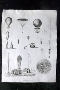
Sold2023Johnson & Exley 1812 Antique Print. Aerostation BalloonCopper Plate Pulished 1812, London for "The Imperial Encyclopaedia; Or, Dictionary of the Sciences and Arts" by William Moore Johnson & Thomas Exley. Paper Size: 10.5 x 8.5 inch (27 x 22cm) Good CondiSee Sold Price
Sold2020Walker, John 1815 Antique Map of World HemispheresCopper Plate Published 1815, London for "The Universal Gazetteer: Being a Concise Description" [Walker's Geography] by John Walker. Folds as issued. Paper Size: 15 x 8 inch (38 x 21cm) Minor toning/ofSee Sold Price
Sold2017Desnos/de la Tour: Antique Map of World in HemispheresTitle/Content of Map: 'Mappe-Monde, dressée pour l'etude de la Géographie, rélativement aux auteurs les plus modernes. Revûë, corrigée et augmentée d'apres les Nouvelles Observations AstronomiqSee Sold Price
Sold2017de la Tour: Antique Map of World; Twin Hemispheres 1777Title/Content of Map: 'Mappemonde' World twin hemispheres Date Printed: 1777 Image Size: Approx 18.5 x 16.5cm, 7.25 x 6.25 inches (Medium); Please note that this is a folding map. Type: Antique copperSee Sold Price
Sold2020Barlow 1807 Antique Map of The World HemispheresCopper Engraved Map Published 1807 by Brightly & Kinnersley, Bungay, England for "A General View of the World, Geographical, Historical and Philosophical" by The Rev. E. Blomfield. Maps Engraved by BaSee Sold Price
Sold2017Bartholomew: Antique Map of World in Hemispheres, 1901The World-Bathy-Orographical; Western Hemisphere; Eastern Hemisphere; Northern Hemisphere; Southern Hemisphere' WORLD TWIN HEMISPHERES. Relief map. Mountains eclipses snowline seasons Date Printed: 19See Sold Price
6 days LeftJasper521761 NEW DICTIONARY OF TRADE & COMMERCE R. ROLT antique FOLIO ILLUSTRATED w/MAPS$440
6 days LeftJasper521660 HISTORY of the WORLD by WALTER RALEIGH antique ILLUSTRATED w/ MAPS English$700
2 days LeftTrillium Antique Prints & Rare BooksPtolemy & Magini, pub. 1620 - Map of the World$50(1 bid)
2 days LeftTrillium Antique Prints & Rare BooksPtolemy & Magini, pub. 1620 - Map of the Ancient World with Africa, Europe, Asia$50
2 days LeftTrillium Antique Prints & Rare BooksMitchell's A New Universal Atlas.. - Volume with 73 Maps$1,000(1 bid)
2 days LeftTrillium Antique Prints & Rare BooksCarey, pub. 1814 - Map of Hindostan or India$50(1 bid)
10 hrs LeftAlbion AuctionsYonge, Charlotte 1863 Folio Hand Col Botanical Print. Medicinal Poppy, Chicory$10(2 bids)
10 hrs LeftAlbion AuctionsYonge, Charlotte 1863 Folio Hand Col Botanical Print. Fly Agaric Mushroom etc$10(2 bids)
10 hrs LeftAlbion AuctionsYonge, Charlotte 1863 Folio Hand Col Print. Mushroom, Chantarelle, Morell$5(1 bid)
2 days LeftTrillium Antique Prints & Rare BooksCarey & Lea's .. American Atlas - Volume with 46 Originally Hand-colored Folio Maps$1,000(1 bid)
2 days LeftTrillium Antique Prints & Rare BooksBraun & Hogenberg, pub. 1575 - View of Cusco, Peru and Mexico$140(3 bids)
2 days LeftTrillium Antique Prints & Rare BooksBraun & Hogenberg, pub. 1575 - View of Jerusalem, Israel$100(1 bid)
2 days LeftTrillium Antique Prints & Rare BooksBraun & Hogenberg, pub. 1575 - View of Ghent, Belgium$100


![Walker, John C1805 Antique Map. World Hemispheres: Copper Engraved Map Published C1805, London for "The Universal Gazetteer: Being a Concise Description" [Walker's Geography] by John Walker. Folds as issued. Paper Size: 13.5 x 8 inch (35 x 20cm) Some](https://p1.liveauctioneers.com/3952/311930/166897808_1_x.jpg?height=310&quality=70&version=1701713718)

![Walker, John 1815 Antique Map of World Hemispheres: Copper Plate Published 1815, London for "The Universal Gazetteer: Being a Concise Description" [Walker's Geography] by John Walker. Folds as issued. Paper Size: 15 x 8 inch (38 x 21cm) Minor toning/of](https://p1.liveauctioneers.com/3952/178149/89724590_1_x.jpg?height=310&quality=70&version=1599136380)


