Sold2023Johnson & Exley 1812 Antique Map. England & WalesCopper Engraved Map Published 1812, London for "The Imperial Encyclopaedia; Or, Dictionary of the Sciences and Arts" by William Moore Johnson & Thomas Exley. Paper Size: 10.5 x 8.5 inch (27 x 22cm) WaSee Sold Price
Sold2023Johnson & Exley 1812 Antique Map. North AmericaCopper Engraved Map Published 1812, London for "The Imperial Encyclopaedia; Or, Dictionary of the Sciences and Arts" by William Moore Johnson & Thomas Exley. Paper Size: 10.5 x 8.5 inch (27 x 22cm) WaSee Sold Price
Sold2024Johnson & Exley 1812 Antique Map. AfricaCopper Engraved Map Published 1812, London for "The Imperial Encyclopaedia; Or, Dictionary of the Sciences and Arts" by William Moore Johnson & Thomas Exley. Paper Size: 10.5 x 8.5 inch (27 x 22cm) WaSee Sold Price
Sold2023Johnson & Exley 1812 Antique Map. AsiaCopper Engraved Map Published 1812, London for "The Imperial Encyclopaedia; Or, Dictionary of the Sciences and Arts" by William Moore Johnson & Thomas Exley. Paper Size: 10.5 x 8.5 inch (27 x 22cm)See Sold Price
Sold2023Johnson & Exley 1812 Antique Map. GermanyCopper Engraved Map Published 1812, London for "The Imperial Encyclopaedia; Or, Dictionary of the Sciences and Arts" by William Moore Johnson & Thomas Exley. Paper Size: 10.5 x 8.5 inch (27 x 22cm) WaSee Sold Price
Sold2023Johnson & Exley 1812 Antique Map. EuropeCopper Engraved Map Published 1812, London for "The Imperial Encyclopaedia; Or, Dictionary of the Sciences and Arts" by William Moore Johnson & Thomas Exley. Paper Size: 10.5 x 8.5 inch (27 x 22cm) WaSee Sold Price
Sold2023Johnson & Exley 1812 Antique Folio Map. World HemispheresCopper Engraved Map Published 1812, London for "The Imperial Encyclopaedia; Or, Dictionary of the Sciences and Arts" by William Moore Johnson & Thomas Exley. Paper Size: 17 x 10.5 inch (43 x 27cm) WatSee Sold Price
Sold2021Guthrie, William 1790 Antique Map. England & WalesCopper Engraved Map Published 1790, London for "A New Geographical, Historical and Commercial Grammar..." by William Guthrie. The maps are by John Senex, Thomas Kitchin and others. Folds as issued. EaSee Sold Price
Sold2021Findlay, Alex C1835 Antique Map. England & WalesSteel Engraved Map Published C1835 by Thomas Kelly, London for "A New and Universal English Dictionary" by the Rev. James Barclay. Maps Drawn & Engraved by Alexander Findlay. Paper Size: 10.5 x 8 inchSee Sold Price
Sold2022Kelly, Christopher 1836 Antique Map. England & WalesCopper Engraved Map Published 1836, London for "A New and Complete System of Universal Geography" by Christopher Kelly. Maps Engraved by Findlay, Wallis and others. Paper Size: 10.5 x 8 inch (27 x 20cSee Sold Price
Sold2023Johnson & Exley 1812 Antique Print. Boa Constrictor, SnakesCopper Plate Pulished 1812, London for "The Imperial Encyclopaedia; Or, Dictionary of the Sciences and Arts" by William Moore Johnson & Thomas Exley. Paper Size: 10.5 x 8.5 inch (27 x 22cm) Good CondiSee Sold Price
Sold2024Russell & Allen (Pub) 1812 Map. England & WalesFolio Copper Engraved Map Published 1812 by Russell and Allen, Manchester for "A New And Commercial System Of Geography" Paper Size: 15.5 x 9 inch (39 x 23cm) Some toning presentSee Sold Price
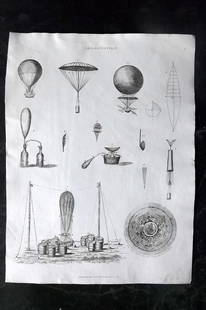
Sold2023Johnson & Exley 1812 Antique Print. Aerostation BalloonCopper Plate Pulished 1812, London for "The Imperial Encyclopaedia; Or, Dictionary of the Sciences and Arts" by William Moore Johnson & Thomas Exley. Paper Size: 10.5 x 8.5 inch (27 x 22cm) Good CondiSee Sold Price
Sold2017Malte-Brun: Antique Map of England & Wales, 1834Map: 1834 Malte-Brun Map of England and Wales -- England and Wales Cartographer: M. Malte-Brun / S. Walker Year / Place: 1834, Boston Map Dimensions: 9.3 x 7.5 in. Condition: Very Good. Nice strike, sSee Sold Price
Sold2018Bartholomew: Antique Map of England & Wales, 1890Title/Content of Map: England & Wales Date Printed: 1890 Cartographer: BARTHOLOMEW, JOHN & CO. Size (inches): 11.25X11.6 "By J. Bartholomew, F.R.G.S." Polar projection. 11 Shows nautical routes. FromSee Sold Price
Sold2019Barclay, James 1809 Antique Map. England and WalesOutline Hand Coloured Copper Engraved Map Published 1809, Leeds for "Barclay's Complete and Universal Dictionary of the English Language..." by the Rev. James Barclay. Paper Size: 10 x 8 inch (26 x 20See Sold Price
Sold2018Weller: Antique Map of England & Wales NW, 1863TITLE/CONTENT OF MAP: 'England & Wales, North-West sheet' Cumbria Lancashire Welsh coast Isle of Man. DATE PRINTED: 1863 IMAGE SIZE: Approx 45.5 x 32.5cm, 17.75 x 12.75 inches (Large) TYPE: Antique maSee Sold Price
Sold2020Walker, John 1815 Antique Map of England & WalesCopper Plate Published 1815, London for "The Universal Gazetteer: Being a Concise Description" [Walker's Geography] by John Walker. Folds as issued. Paper Size: 10 x 8 inch (25 x 20cm) Minor toning/ofSee Sold Price
Sold2021Barlow 1807 Antique Map. England and WalesCopper Engraved Map Published 1807 by Brightly & Kinnersley, Bungay, England for "A General View of the World, Geographical, Historical and Philosophical" by The Rev. E. Blomfield. Engraved by Barlow.See Sold Price
Sold2018Mitchell: Antique Map of England and Wales, 1870Title/Content of Map: County Map of England, and Wales Cartographer: S. A. Mitchell Place & Date: Philadelphia / 1870 Size: 10 5/8" x 13 1/2" Condition: full color; light overall age toning The beautiSee Sold Price
Sold20231866 Johnson Map of England and Wales -- Johnson's England and WalesTitle: 1866 Johnson Map of England and Wales -- Johnson's England and Wales Cartographer: Johnson & Ward Year / Place: 1866, New York Map Dimension (in.): 24.7 X 17 in. This is a superb map of EnglandSee Sold Price
Sold2021Kitchin, Thomas 1785 Antique Map of England and Wales"England and Wales with the Roads from the latest Surveys" Copper Engraved Map Published 1783-85, London for "A New Geographical, Historical and Commercial Grammar..." by William Guthrie. Drawn and EnSee Sold Price
Sold2022Barclay, James 1812 Hand Col Map. England & WalesHand Colored Copper Engraved Map Published 1812-13 by Brightly & Childs, Bungay for "A Complete and Universal Dictionary of the English Language..." by the Rev. James Barclay. Paper Size: 10.5 x 8 incSee Sold Price
Sold2021Kitchin, Thomas 1785 Antique Map of England and Wales"England and Wales with the Roads from the latest Surveys" Copper Engraved Map Published 1783-85, London for "A New Geographical, Historical and Commercial Grammar..." by William Guthrie. Drawn and EnSee Sold Price
7 days LeftHunt and Peck Estate Services, Inc.1788 Henry Boswell "Historical Descriptions of New and Elegant Picturesque Views of the Antiquities$50(1 bid)
5 days LeftJasper521894 Johnson Map of New England States -- Johnson's Section Map and Index of the New England States$80
2 days LeftTrillium Antique Prints & Rare BooksCarey, pub. 1814 - Map of New South Wales, Australia$50
2 days LeftTrillium Antique Prints & Rare BooksCatesby & Seligmann - Summer Redbird & Sycamore. 12$50


![Walker, John 1815 Antique Map of England & Wales: Copper Plate Published 1815, London for "The Universal Gazetteer: Being a Concise Description" [Walker's Geography] by John Walker. Folds as issued. Paper Size: 10 x 8 inch (25 x 20cm) Minor toning/of](https://p1.liveauctioneers.com/3952/178586/89905083_1_x.jpg?height=310&quality=70&version=1599488807)


