Sold202319th century. A hand-colored American Civil War era map of Virginia, Delaware, Maryland, and West19th century. A hand-colored American Civil War era map of Virginia, Delaware, Maryland, and West Virginia. Published by A.J. Johnson New York USA. Marked as page 47. Overall good condition; some browSee Sold Price
Sold2017Johnson’s Civil War era map of North & South CarolinaHistoric map shows the Carolinas in great detail shortly following the outbreak of the Civil War. States hand-colored at the time of publishing with color coding according to county. Inset map depictsSee Sold Price
Sold20231894 Cowles Civil War Map of Northern Virginia, Maryland, Delaware and Parts of West Virginia andTitle: 1894 Cowles Civil War Map of Northern Virginia, Maryland, Delaware and Parts of West Virginia and Pennsylvania -- General Topographical Map, Sheet I [Plate CXXXVI] Cartographer: C Cowles (compiSee Sold Price
Sold2021CIVIL WAR-ERA JOHNSON'S MILITARY MAP UNITED STATESFramed engraving with color on paper, "Johnson's New Military Map of the United States, Showing the Forts, Military Posts & c., with Enlarged Plans of Southern Harbors from Authentic Data Obtained atSee Sold Price
Sold20241862 Civil War-era map of Alabama/Georgia, Johnson & WardJohnson’s Georgia and Alabama from the 1862 edition of Johnson’s Family Atlas published during the second year of the war in 1862 by Johnson & Ward. Shows railroads operating at the beginnSee Sold Price
Sold2020Early Civil War era map of AmericaNice example of A. J. Johnson's 1862 map of North America. Presents a fascinating snapshot of North America just after the outbreak of the American Civil War. States generally follow the 1861 configurSee Sold Price
Sold2022Significant United States map, 1864 Johnson & WardVery interesting hand-colored map created at a pivotal time in the settlement of the American West. In this lovely Civil War era map many of the western states have still not settled their borders. ArSee Sold Price
Sold2024Civil War era map of N. America with unsettled state bordersOne of the key maps in the 1860s Johnson series of North America. In this map Idaho Territory encompasses what would eventually become Idaho, Montana and Wyoming. Dakota Territory has yet to split intSee Sold Price
Sold2023Civil War era map of N. America with unsettled state bordersOne of the key maps in the 1860s Johnson series of North America. In this map Dakota Territory has yet to split into its north and south divisions while it stretches to encompass what will eventuallySee Sold Price
Sold2024Scarce Georgia-Alabama Civil War-era RR map by Johnson & Browning, 1861Johnson’s Georgia and Alabama from the scarce 1861 edition of Johnson’s Family Atlas published shortly after the outbreak of the war in 1861 by Johnson & Browning. Shows network of railroaSee Sold Price
Sold2022Civil War era map of N. America with unsettled state bordersOne of the key maps in the 1860s Johnson series of North America. In this map Idaho Territory encompasses what would eventually become Idaho, Montana and Wyoming. Dakota Territory has yet to split intSee Sold Price
Sold2019United States. Civil war era military map. ShowingTitle/Content of Map: United States. Civil war era military map. Showing southern ports Date: 1863 Cartographer: By Johnson & Ward. From, Johnson’s New Illustrated Family Atlas Size: 18x 26 1/4”.See Sold Price
Sold202419th C. Johnson’s Florida Map1863 Civil War era colored map of Florida by Alvin Jewett Johnson, published by A.J Johnson New York. Unframed in protective sleeve. Measures just shy of 14 inches by 18 inches.See Sold Price
Sold2023FRAMED 19TH C. JOHNSON'S FLORIDA MAP1863 Civil War Era Colored Map of Florida, by Alvin Jewett Johnson (1827-1884), published by Johnson & Ward, New York, in a gilded and green painted wooden frame with mat, glazed, OS: 19 1/2" x 23 1/2See Sold Price
Sold201619thc Civil War Map, Invasion of PennsylvaniaOriginal 19th Century Map, Page from "Harper's Pictorial History Of The Civil War." Shows Pennsylvania, Maryland ,Virginia & Delaware. Gettysburg, Philadelphia & Washington. June, 1863. Approx 10" X 1See Sold Price
Sold2016Large 1862 US Civil War Wall MapColton's Map of the Southern States. Including Maryland, Delaware, Virginia, Kentucky, Tennessee, Missouri, North Carolina, South Carolina, Georgia, Alabama, Mississippi, Arkansas, Louisiana, Texas ..See Sold Price
Sold2022Vintage RR map of Maryland & Delaware, 1850Excellent 1850 map of Maryland and Delaware with a chart of Chesapeake Bay Steamboat Routes. Published a decade before the Civil War and during an explosion in the country's railroad routes, the map aSee Sold Price
Sold20231862 Civil War, Coltons New Topographical Map of The States of Virginia, Maryland and DelawareHistoric Maps 1862 Civil War "Colton's New Topographical Map of The States of Virginia, Maryland and Delaware" Hardcover Folio 1862-Dated Civil War Period, Hand-colored 45.25" x 31.5" Folding Map titlSee Sold Price
Sold20181864 Johnson Map of the United States -- Johnson'sTitle/Content of Map: 1864 Johnson Map of the United States -- Johnson's United States Date: 1864, New York Cartographer: A Johnson Size: 16.9 x 23.1 in. This is a large, highly detailed Civil War eraSee Sold Price
Sold2020Johnson's IllinoisTitle/Content of Map: Johnson's Illinois Cartographer: JOHNSON, ALVIN JEWETT Date: 1866 Publisher: A.J. Johnson Size: 22Height - 15.6Width Larger Civil War era Illinois. Slightly browned. EncapsulatedSee Sold Price
Sold2017Civil War Era Map of Charleston, SC and EnvironsE & G. W. Blunt's Map of Charleston and Vicinity (New York: E & G. W. Blunt, 1862), a handy map for military purposes showing both land and sea routes in the region. Unframed in a 1950s mailing/storagSee Sold Price
Sold2021Civil War Era Maryland State Seal Militia Cuff ButtonCivil War Era Maryland State Seal Militia Cuff Buttonnon-dug, 15mm, "* EXTRA * / QUALITY" depressed mark. Additional high-resolution photos are available at www.lelandlittle.comSee Sold Price
Sold2022AN AMERICAN CIVIL WAR ERA MAP, "United States of North America (Eastern & Central)," LONDON,AN AMERICAN CIVIL WAR ERA MAP, "United States of North America (Eastern & Central)," LONDON, 1861-1873, THEODORE ETTLING (b. 1823), hand colored lithograph on paper, by T. Ettling, published by CasselSee Sold Price
Sold2017Civil War Era Map of the United StatesUnited States. Taliaferro Preston Shaffner (1811 – 1881). Lithographed Map. London: Schaffner, 1862. 12 1/4 x 18 1/2 inchesSee Sold Price
Jul 07Case Antiques, Inc. Auctions & Appraisals3 Civil War Era Photos, incl. Rose O'Neal Greenhow, poss. Jeff Davis$150
Jul 04Weatherham Estate TreasuresAbraham Lincoln Bronze Bust Sculpture On Marble Base - Signed Original - 10lbs$400
43 mins LeftSchilb Antiquarian Rare Books1918 Robert E Lee Civil WAR Confederate General CSA Battles MAPS Illustrated$66(6 bids)
Featured3 days LeftUniversity ArchivesAbraham Lincoln PSA GEM MT 10 CDV, Signed 3 Weeks Before His Death.$30,000(1 bid)
43 mins LeftSchilb Antiquarian Rare Books1890 1ed Confederate Memoirs of Joseph Johnston & Jefferson Davis Civil War CSA$66(3 bids)
Featured3 days LeftUniversity ArchivesCapture of Jefferson Davis: “Mr. Davis tried to escape…with a ladies waterproof$1,600
4 days LeftSwann Auction Galleries(CIVIL WAR--CONFEDERATE.) A late issue of the Daily Constitutionalist, one of the last Confederate$450
Jul 14Schilb Antiquarian Rare Books1928 Life of Abraham Lincoln 1ed SLAVERY Civil War Albert Beveridge 2v SET$1(1 bid)
4 days LeftSwann Auction Galleries(ABRAHAM LINCOLN.) [Alexander Gardner], photographer. Carte-de-visite "inkwell portrait" of the$1,500
Jul 14Schilb Antiquarian Rare Books1885 Civil War 1ed Memoirs of Union General Ulysses S. Grant Illustrated MAPS 2v$135(7 bids)
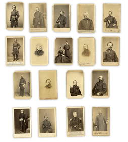
3 days LeftUniversity Archives18 pc. CDV Archive of Civil War Generals Incl. Many Brady & E. Anthony Examples$260(1 bid)
Jul 06Case Antiques, Inc. Auctions & AppraisalsCivil War Veteran GAR Uniform, PVT Stephen F. Oliver$200(1 bid)
3 days LeftUniversity ArchivesIconic U.S. Grant Battlefield Albumen by Mathew Brady at City Point During Siege of Petersburg$400
43 mins LeftSchilb Antiquarian Rare Books1860 Political Textbook 1ed SLAVERY Abe Lincoln Douglass Civil War Government$74(4 bids)
5 days LeftSouth Florida Auction & Estate Sale Services IncABRAHAM LINCOLN Memorial Belt Buckle Approved by MRS. LINCOLN$22(2 bids)
5 days LeftSouth Florida Auction & Estate Sale Services IncCivil War Abraham Lincoln Tin Type Photograph$8(2 bids)
512 Lots AwayMynt AuctionsMort Kunstler Civil War Print Robert E Lee at Fredericksburg Custom Framed$10


![1894 Cowles Civil War Map of Northern Virginia, Maryland, Delaware and Parts of West Virginia and: Title: 1894 Cowles Civil War Map of Northern Virginia, Maryland, Delaware and Parts of West Virginia and Pennsylvania -- General Topographical Map, Sheet I [Plate CXXXVI] Cartographer: C Cowles (compi](https://p1.liveauctioneers.com/5584/300803/160207035_1_x.jpg?height=310&quality=70&version=1693946338)


![(ABRAHAM LINCOLN.) [Alexander Gardner], photographer. Carte-de-visite "inkwell portrait" of the (1 of 1)](https://p1.liveauctioneers.com/199/334052/180497937_1_x.jpg?height=282&quality=70&version=1718909401)