Sold2020London Mag 1758 Map. Map of the Rhine, Germany"A Map of the Rhine between Wesel & Duseldorp Shewing the Country round Crevelt Where the Battle Was Fought between the Allied & French Armies June 23, 1758" Copper Engraved Map Published 1732-85, LonSee Sold Price
Sold2020London Mag 1758 Map. French Armies in Germany"A Map shewing ye Situation of the French & Allied Armies in Germany" Copper Engraved Map Published 1732-85, London for "The London Magazine" Paper Size: 8 x 5 inch (21 x 14cm) Chipping to bottom margSee Sold Price
Sold2021London Mag 1758 Map. French Armies in Germany"A Map shewing ye Situation of the French & Allied Armies in Germany" Copper Engraved Map Published 1732-85, London for "The London Magazine" Paper Size: 8 x 5 inch (21 x 14cm) Chipping to bottom margSee Sold Price
Sold2020Gentleman's Mag 1759 Map. Westphalia, Germany"A Map of that Part of Westphalia, in which the French Army where defeated Aug. 1. 1759" Copper Engraved Map Published London 1731-1833, London for "The Gentleman's Magazine..." by Various ContributorSee Sold Price
Sold2022Gentleman's Mag 1759 Map. Westphalia, Germany"A Map of that Part of Westphalia, in which the French Army where defeated Aug. 1. 1759" Copper Engraved Map Published London 1731-1833, London for "The Gentleman's Magazine..." by Various ContributorSee Sold Price
Sold2021Gentleman's Mag 1759 Map. Westphalia, Germany"A Map of that Part of Westphalia, in which the French Army where defeated Aug. 1. 1759" Copper Engraved Map Published London 1731-1833, London for "The Gentleman's Magazine..." by Various ContributorSee Sold Price
Sold2022Tombleson, William 1834 Map of the River Rhine"Tombleson's Upper Rhine" Showing Germany and Switzerland. Steel Engraved Map Published 1832-34, London for "Tombleson's Upper Rhine" Edited by William Gray Fearnside. Illustrated by William TomblesonSee Sold Price
Sold2023Baedeker, Karl 1900 Lot of 63 Maps. Rhine - Germany, Netherlands, AustriaLithograph Maps Published 1900, Leipzig for "The Rhine from Rotterdam to Constance" by Karl Baedeker. Folds as issued. Paper Size: Up to 22.5 x 6 inch (57 x 15cm) Good ConditionSee Sold Price
Sold2023Map of Germany and Sweden, &c. GENTLEMAN'S MAGAZINE. GENTS MAG 1741 oldTITLE/CONTENT OF MAP: 'Map of Germany and Sweden, &c' DATE PRINTED: 1741 IMAGE SIZE: Approx 19.5 x 11.0cm, 7.5 x 4.25 inches (Small) TYPE: Antique copperplate map CONDITION: Good; suitable for framingSee Sold Price
Sold2017[MAP] FREDERICK DE WIT (DUTCH, 1630-1706)Map of North Rhine-Westphalia, Germany, c. 1680See Sold Price
Sold2019Kitchin, Thomas 1758 Map of England and Wales"A New Map of England and Wales" Copper Engraved Map Published 1758, London for "A Complete History of England…" by Thomas Smollett. Map by Thomas Kitchin (Kitchen) Folds as issued. Paper Size: 20 xSee Sold Price
Sold2022Times Atlas 1895 Lot of 7 Maps. GermanyLithograph Map Published 1895, London for "The Times Atlas" Two with Centre fold as published. Paper Size: Up to 21 x 16 inch (53 x 41cm) A couple with centre fold splits. A few other minor faults inSee Sold Price
Sold2021Guthrie, William 1806 Map. GermanyCopper Engraved Map Published 1806, London for "A New Geographical, Historical and Commercial Grammar..." by William Guthrie. The maps are by John Senex, Thomas Kitchin and others. Folds as issued. PaSee Sold Price
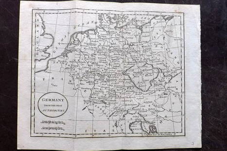
Sold2021Guthrie, William 1798 Map. GermanyCopper Engraved Map Published 1798, London for "A New Geographical, Historical and Commercial Grammar..." by William Guthrie. The maps are by John Senex, Thomas Kitchin and others. Folds as issued. PaSee Sold Price
Sold2021Guthrie, William 1798 Map. GermanyCopper Engraved Map Published 1798, London for "A New Geographical, Historical and Commercial Grammar..." by William Guthrie. The maps are by John Senex, Thomas Kitchin and others. Folds as issued. PaSee Sold Price
Sold2023Johnson & Exley 1812 Antique Map. GermanyCopper Engraved Map Published 1812, London for "The Imperial Encyclopaedia; Or, Dictionary of the Sciences and Arts" by William Moore Johnson & Thomas Exley. Paper Size: 10.5 x 8.5 inch (27 x 22cm) WaSee Sold Price
Sold2022Kelly, Christopher 1816 Map. GermanyCopper Engraved Map Published 1816, London for "A New and Complete System of Universal Geography" by Christopher Kelly. Maps Engraved by Findlay, Wallis and others. Folds as issued. Paper Size: 16 x 1See Sold Price
Sold2023Baines, Edward 1817 Antique Map. Germany"Map of Germany as designed by the treaty of Paris concluded May 30th 1814" Copper Engraved Map Published 1817, London for "History of the Wars of the French Revolution..." by Edward Baines. Folds asSee Sold Price
Sold2022Guthrie & Kitchin 1782 Map. GermanyCopper Engraved Map Published 1782, London for "A New Geographical, Historical and Commercial Grammar..." by William Guthrie. The maps are by John Senex, Thomas Kitchin and others. Folds as issued. PaSee Sold Price
Sold2019Gross, Alexander 1920 Lot of 6 Large Maps. GermanyLarge Lithograph Maps Published 1920, London for "The Daily Telegraph Victory Atlas of the World" by Alexander Gross. Centre fold as published. Paper Size: 25 x 19.5 inch (64 x 49cm) Good ConditionSee Sold Price
Sold2019The Times 1895 Lot of 4 Maps. GermanyLithograph Maps Published 1895, London for "The Times Atlas" Paper Size: 16 x 10.5 inch (41 x 27cm) and one double sized. Good ConditionSee Sold Price
Sold2019Walker, John 1795 Lot of 4 Maps. Germany, SwitzerlandAlso Turkey in Europe and Sweden, Denmark, Norway. Copper Engraved Maps Published 1795, London for "Elements of Geography, and of Natural and Civil History" by John Walker. Centre fold as published. PSee Sold Price
Sold2021Wilkes, John 1805 Hand Col Map. GermanyFinely Hand Colored Copper Engraved Map Published 1796-1828 London for "Encyclopaedia Londinensis, or universal dictionary of arts, sciences and literature" by John Wilkes et al. Paper Size: 10.5 x 8.See Sold Price
Sold2022Lyttleton, George 1810 Antique Map of Germany"Germany Exhibiting the present seat of War 1805" Copper Engraved Map Published 1810, London for "The History of England..." by George Courtney Lyttleton. Folds as issued. Paper Size: 17.5 x 16 inch (See Sold Price
7 days LeftUniversity ArchivesScarce Early Printing: "An Account of the European Settlement in America in 6 Parts..."$100
1818 AuctioneersAntiquarian. Theology. A small selection, includes: Sales, B. St. Francis - The Spiritual Directer£28
6 days LeftJasper521598 Munster View of Speyer, Germany -- Die Reichsstatt Speier, so vor Zeiten Civitas Nemetum: das$110
6 days LeftAkiba Galleries(2 Pc) Allain Manesson Mallet Description De L'Univers 2 Vol. German Translation$200(1 bid)
6 days LeftJasper521914 Rand McNally Map of Austria-Hungary [verso] German Empire -- Austria-Hungary [verso] German$30
4 days LeftSchilb Antiquarian Rare Books1859 AFRICA VOYAGES Barth Timbuktu Tripoli SLAVES Illustrated Slavery MAP African$62(4 bids)
7 days LeftUniversity ArchivesFeb. 1777 Issue of The Gentleman's Magazine with Superb Map of Philadelphia$140(1 bid)
7 days LeftUniversity ArchivesDeclaration of Independence, Very Early British Publ. in Gentleman's Magazine & Rare Map$1,000
4 days LeftSchilb Antiquarian Rare Books1844 Siege of Gibraltar American Revolution SPAIN France Drinkwater MAP History$2(2 bids)
May 16Zikorn Arts & History ObjectsWest Indies, Providence, Windward, Cuba 1834 British Admiralty Map$100(1 bid)
May 16Zikorn Arts & History ObjectsEntrance to Baltic Great & Little Belt 1852 British Admiralty Map$100
6 days LeftJasper521869 Mitchell Map of Much of Western Europe -- XXXII Prussia the German States Holland & Belgium$30


![[MAP] FREDERICK DE WIT (DUTCH, 1630-1706): Map of North Rhine-Westphalia, Germany, c. 1680](https://p1.liveauctioneers.com/3820/102962/52635921_1_x.jpg?height=310&quality=70&version=1492789342)


![1914 Rand McNally Map of Austria-Hungary [verso] German Empire -- Austria-Hungary [verso] German (1 of 2)](https://p1.liveauctioneers.com/5584/328338/176911532_1_x.jpg?height=282&quality=70&version=1715113718)


